Search for Posts, Maps, and Topics
Episode 2 Description: Racers travel to Madrid, Spain where a new alliance emerges, and one team’s Express Pass strategy comes with instant regret.
Episode Airdate: Thursday, October 1st, 2026 on CBS
The twelve teams flew from Vancouver, CANADA for a stopover in Paris, FRANCE before arriving in Madrid, SPAIN. In the “Who’s Feeling Saucy?” Roadblock, one member on each team participated in a throwback challenge that was previously encountered in season 10. Teams visited the Plaza de Toros El Batán bullfighting ring — in the community of Batán west of Madrid — and encountered a large pile of tomatoes in the center. Locals greeted the Amazing Race teams by pelting them with many tomatoes! Just like in season 10, some competitors were pelted so hard that they felt the ouchy impact. This task pays homage to the very popular, annual La Tomatina spectacle in the eastern Spanish town of Buñol in VALENCIA where over 40,000 people throw hundreds of thousands of tomatoes! Teams searched the pile for a small capsule clue containing an image of Madrid’s Puerta del Sol (Gate of the Sun) public square, their next destination. Daisha and Dalton used their Express Pass since they (and other teams) struggled with finding a clue among the thousands of tomatoes.
To access the Puerta del Sol in Madrid, teams rode the Metro train. Sisters Charlotte and Katie were the last team to arrive and boarded the wrong train; they made a spelling mishap when they went to the Puerta del Sur (not Sol) train stop! Erin and Javi also made this mistake initially but Erin noticed the discrepancy; the team therefore boarded the correct train in first place. Teams arrived in the beautiful and vibrant public square and chose between the “Slice of Ham” or “Slice of History” Detour.
In the “Slice of Ham” detour option, teams carried a giant pork leg known as a jamón ibérico (Iberian ham) and had it sliced by a chef at a restaurant. Teams arranged this ham along with grapes, kiwi, peapods, a dipping sauce, several cheeses, and more on a charcuterie board to the chef’s liking. This task definitely included attention to detail; for example, they had to slice a cheese in thin triangle shapes and arrange it in a radial circle. Cody and Jaime used their Express Pass.
Teams choosing “Slice of History” detour option met twelve local Spaniards dressed as famous people in Spain’s history and modern times. Each Spaniard mentioned a fact about the famous person he or she is representing, and teams matched the impersonator’s portraits with the famous people’s names based on the facts. The famous Spaniards are authors/writers (Rosalía de Castro and Don Quixote author Miguel de Cervantes), artists (Salvador Dali, Pablo Picasso, and Diego Velázquez), a teacher (María Elena Maseras Ribera), explorers (Hernán Cortés and Juan Ponce de León), queens (Queen Isabel I of Castile and Queen Letizia), and politicians (Clara Campoamor and Dolores Ibárruri). Jenn and Jody used their Express Pass even though Jody is actually a history teacher!
After completing the detour task of their choice, teams travelled nearby to the Plaza de España Pit Stop in Madrid. Ali and Joanna worked their way up from their 10th place finish in the previous episode and arrived first at the mat, where Phil and a Spanish matador greeted them. Phil asked Ali and Joanna if they know where Tasmania is continentally located. They enthusiastically exclaimed “AFRICA!!!” but Phil replied that the island belongs to the continent (and country) of AUSTRALIA.
Season 39, Episode 2 Results
1st — Ali and Joanna
1st place prize — vacation to Tasmania, AUSTRALIA
2nd — Matt and Michelle
3rd — Cody and Jaime
4th — Ann-Marie and Riley
5th — Jenn and Jody
6th — Daisha and Dalton
7th — Erin and Javi
8th — Andrea and Anuar
9th — Conner and Garrett
10th — Doug and Dylan
11th — Dafina and Saran
12th — Charlotte and Katie
Eliminated from the competition

1) Which country's economy is more dependent on fisheries than the other two options?
A — BURKINA FASO
B — NORWAY
C — BOLIVIA
2) What Central American country was formerly known as British Honduras?
A — BELIZE
B — COSTA RICA
C — PANAMA
3) When Prophet Muhammad left Mecca, he traveled north to which now-sacred city in SAUDI ARABIA?
A — Tabuk
B — Riyadh
C — Medina
4) Central Bengal, Eastern Bengal, Northern Bengal, and Southern Bengal are regions in which country?
A — PAKISTAN
B — THAILAND
C — BANGLADESH
ANSWERS
Question 1:
B . . . . . Norway
Question 2:
A . . . . . Belize
Question 3:
C . . . . . Medina
Question 4:
C . . . . . Bangladesh
1) The Principality of MONACO borders which sea?
A — Caspian Sea
B — Mediterranean Sea
C — Sulu Sea
2) According to data in the year 2022, IRAN has an overall adult literacy rate of _________.
A — 23%
B — 61%
C — 89%
3) True or false: rainbows are very common in Antarctica.
4) While there are several San Juan counties in the Western UNITED STATES, one of these has the highest number of neighboring counties (14) in the U.S. It is also one of the largest counties with a 7,933 square-mile area. Which state is this county located in?
A — Washington
B — Colorado
C — New Mexico
D — Utah
ANSWERS
Question 1:
B . . . . . Mediterranean Sea
Question 2:
C . . . . . 89%
Question 3:
False: they are quite rare in Antarctica; colorless icy haloes are more frequent.
Question 4:
D . . . . . Utah (↗)
Have a Happy Saint Patrick's Day on March 17th!
Interestingly shaped like an orange slice (or semicircle if you prefer), Akimiski is a geographic feature in the east-central area of CANADA. It is east of the First Nation community known as Attawapiskat. The Akimiski Strait is wedged between the island and Attawapiskat. Which of the following sentences about Akimiski is false?
A — The name Akimiski means “land across the water” in Swampy Cree’s language.
B — Akimiski is a coral reef.
C — Akimiski is part of Nunavut even though it is geographically closer to Ontario.
D — Akimiski is the largest island located in James Bay.
Answer:
B — Akimiski is a coral reef.
(Akimiski is an island as referenced in answer choice D.)
Here's to a New Year's Resolution of learning about our amazing planet!
1) Which of the following is not a city in ROMANIA?
A — Bucharest (București)
B — Timișoara
C — Belgrade (Beograd)
2) Which state in the UNITED STATES has exactly 100 counties? Some of these counties include Durham, Mecklenburg, Orange, Pitt, Wake, and Watauga.
A — Vermont
B — North Carolina
C — New Mexico
3) BANGLADESH is mostly bordered by INDIA but also shares a border in the southeast with _____________.
A — MYANMAR
B — NEPAL
C — PHILIPPINES
ANSWERS
Question 1:
C . . . . . Belgrade (Beograd) which is the capital of Serbia (↗)
Question 2:
B . . . . . North Carolina (↗)
Question 3:
A . . . . . Myanmar (↗)
Happy Holidays, Merry Christmas, and Happy New Year!
1) Which of the following is not a city in NORWAY?
A — Stockholm
B — Oslo
C — Bergen
D — Trondheim
2) In late summer 2024, over 20 silver Roman denarii coins were discovered inside a wall hole at an acropolis on the Mediterranean island of Pantelleria. The Italian island is located between ITALY and which country in Africa?
A — CAMEROON
B — TUNISIA
C — ETHIOPIA
3) Which two states in the UNITED STATES have more than 80 counties each?
A — Arizona and Nevada
B — Michigan and Minnesota
C — Connecticut and Rhode Island
D — North Dakota and South Dakota
ANSWERS
Question 1:
A . . . . . Stockholm which is the capital of Sweden (↗)
Question 2:
B . . . . . Tunisia
Question 3:
B . . . . . Michigan and Minnesota
1) The Congo Pedicle is a foot-like panhandle region in the southeastern corner of the DEMOCRATIC REPUBLIC OF THE CONGO and situated near ZAMBIA. The pedicle area features a national park known as Demalisques de Leshwe, possibly named after the genus (damaliscus) of which animal?
A — sloth
B — aardvark
C — antelope
D — penguin
2) True or false: There is an island named Komodo in INDONESIA.
3) The third highest mountain the world is Kangchenjunga, a Himalayan peak standing over 8,500 meters and 28,000 feet tall. Kangchenjunga is situated on the border between INDIA and what mountainous country flying a double pennant shaped flag?
A — ARGENTINA
B — BANGLADESH
C — SWITZERLAND
D — NEPAL
ANSWERS
Question 1:
C . . . . . antelope
Question 2:
True . . . . . it is home to the world-renown Komodo dragon!
Question 3:
D . . . . . Nepal
There is a county in Missouri named for a river and a particular group of people in FRANCE who were stereotypically known for being boastful and boisterous. This county’s name is a lowercased word in the Merriam-Webster dictionary. Which county is it? Choose an option and find the answer further below!
A — Audrain County
B — Gasconade County
C — Chariton County
D — Buchanan County
Answer:
B — Gasconade County
Happy Mother's Day on Sunday!
1) Fill in the blank: along the mighty Zambezi River, _________ of ZAMBIA and ZIMBABWE is the world’s largest artificial lake by volume as of the year 2023.
A — Lake Baikal
B — Lake Kariba
C — Lake Tanganyika
2) True or false: The community of Nahwa in the UNITED ARAB EMIRATES is completely surrounded by Madhā in OMAN. Also, the doughnut-shaped territory of Madhā is surrounded by additional land of the United Arab Emirates.
3) Fill in the blank: standing at over 8,281 feet (2,524 meters) in elevation, the highest mountain of SRI LANKA is _________.
A — Dealul Balanesti
B — Pidurutalagala
C — Hombori Tondo
ANSWERS
Question 1:
B . . . . . Lake Kariba
Question 2:
True . . . . . Nahwa is rare phenomenon known as a counter-exclave — in which an exclave (Nahwa) is surrounded by another exclave (Madhā). Nahwa is the “egg yolk” to Madhā’s “egg white”!
Question 3:
B . . . . . Pidurutalagala
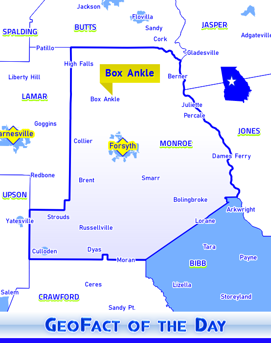
Box Ankle is an interestingly named community in Monroe County in the state of Georgia! Plenty of details on the naming of Box Ankle are provided by Georgia Public Broadcasting (↗). Surrounding communities include Collier, Forsyth (county seat of Monroe County), Goggins, and High Falls.
While the hot season of summer is winding down, a town in Metcalfe County in the state of Kentucky has a name evoking the relief of finding shelter from the blistering sun. A census-designated place with the name of Summer Shade seems to have summer all year long — but in name only! The all-seasons community of Summer Shade is nestled near the southwestern corner of Metcalfe County near Barren and Monroe counties. Surrounding communities include Cedar Flats, Curtis, Cyclone, Dubre, Edmonton (county seat of Metcalfe County), Goodluck, Kino, Randolph, and of course Willow Shade.
This is the flag of Montserrado County, a county in western LIBERIA with about 1.5 million residents and home to Liberia’s national capital, Monrovia. Each of the 15 counties in Liberia has a miniature version of the Liberian flag in the top-left corner of its flag. The light blue circle in the center of Montserrado County’s flag contains a whimsical depiction of a small house surrounded by towering trees.
This county is one of the smallest in Liberia. Its geographic area is 1809.4 square kilometers and 1057.9 square miles, or about 2.5% of Liberia’s area. In addition to Monrovia, cities and communities in Montserrado County include Arthington, Bensonville (county capital), Careysburg, Jimoliba, Mount Coffee, Nyehn, Paynesville, and Zannah.
Bordering the Lac qui Parle Lake and Minnesota River, I am a county in southwestern Minnesota and was established in the year 1870, making me over 150 years old! I am so tantalizingly close to South Dakota; I'm only about 20 miles (32.2 kilometers) away. State Roads 7, 23, 29, 40, and 277 as well as U.S. Routes 49 and 212 are major highways, and I'm named after a Native American tribal group. My neighbors are Kandiyohi, Lac qui Parle, Renville, Swift (not Taylor Swift, though...I wish!), and Yellow Medicine counties. With approximately 5,000 residents, the town of Montevideo serves as my county seat and shares the same name as URUGUAY's national capital. What in the World is my name? Choose an option and find out below!
A — Sioux County
B — Chippewa County
C — Oglala Lakota County
Answer: B — my name is Chippewa County
Happy Mother's Day!
 As you can see by the "sea of blue" stretching across the map above, a vast majority of counties (68) in Indiana, USA are named after honorable people who were either born as an American or British citizen. Adams, Harrison, Jackson, Jefferson, Madison, Monroe, and Washington counties are named in honor of U.S. Presidents. Four counties are named in honor of Native American groups/nations or individuals: Delaware (Delaware nation), Elkhart County (possibly Chief Elkhart), Miami County (Miami nation), and Wells County (William Wells, raised by Miami natives).
Three counties are named for war heroes who were born within the geographic territory (Holy Roman Empire, Prussia, etc.) that is now considered present-day GERMANY: DeKalb County (Johann de Kalb, a baron), Jasper County (William Jasper), and Steuben County (Baron von Steuben). Sergeant William Jasper's birthplace is disputed, but South Carolina Educational Television's Knowitall.org website (↗) theorizes that he likely emigrated from Germany to Philadelphia in 1767 (at about age 17) and later moved to the South, eventually rescuing the South Carolinian flag at Fort Moultrie. The United States Mint's 2016 America the Beautiful quarter for South Carolina (↗) depicts an active and heroic scene at Fort Moultrie; on this coin, Jasper is "returning the regimental flag to the ramparts while under attack from a British ship."
Tadeusz Kosciuszko (Kosciusko) and Kazimierz Pulaski were born in present-day POLAND. Toussaint Dubois was born near present-day Montreal, CANADA, Gilbert du Motier (Marquis de la Fayette) was born in FRANCE, Richard Montgomery was born in the Kingdom of IRELAND, and Francis Vigo was born in present-day ITALY. Only 11 counties are not named after war heroes, patriots, leaders, Native American groups, or Native American individuals: LaGrange, Lake, LaPorte, Ohio, Orange, Saint Joseph, Switzerland, Tippecanoe, Union, Vermillion, and Wabash counties.
Bonus Fact: Alexander Hamilton — who is honored in the name of Hamilton County in Indiana and seven other states — was born in the city of Charleston, British Leeward Islands. Charleston sits on Nevis island which is presently part of the country SAINT KITTS AND NEVIS.
 Location of Mississippi County, Arkansas, UNITED STATES: northeast Arkansas, bordering the states of Missouri and Tennessee
Population: 46,480 (2010 U.S. Census)
Surrounding counties: Craighead, Crittenden, Dunklin (Missouri), Dyer (Tennessee), Lauderdale (Tennessee), Pemiscot (Missouri), Poinsett, and Tipton (Tennessee)
Towns and cities throughout Mississippi County include Armorel, Bassett, Birdsong, Blytheville, Burdette, Dean’s Island, Dell, Dyess, Etowah, Gosnell, Joiner, Keiser, Leachville, Luxora, Manila, Marie, Osceola, Tomato, Victoria, Whisp, and Wilson. This county has two county seats marked by stars on the flag: Blytheville and Osceola
The State of Alabama in the UNITED STATES maintains a constellation of public lakes throughout its territory. The map below shows how public county lakes are present in 21 counties located in various geographic regions. There are indeed public lakes in some other Alabamian counties that are not blue-shaded, but this map indicates the 21 counties that have at least one lake with "public county lake" or "county lake" in its name.

In alphabetical order, the 21 blue-shaded counties are Barbour, Bibb, Chambers, Clay, Coffee, Conecuh, Crenshaw, Dale, Dallas, DeKalb, Escambia, Fayette, Geneva, Lamar, Lee, Madison, Marion, Monroe, Pike, Walker, and Washington. Marengo County used to be part of the state’s county-lake system, but the 40-acre public lake is now “privately owned” according to the Marengo Lake Web Page (↗). Fish icons for county public lakes — except for Concecuh County — are displayed in the 2017-2018 Alabama Official Transportation Map.
 More than a couple dozen villages and towns in Arkansas (UNITED STATES) share the same names with countries and capital cities around the world. While not known as countries in the fully sovereign sense, England and Scotland are commonly known as countries nestled within the greater United Kingdom. Also, non-sovereign Palestine is recognized by 137 countries to be an official state as of December 2018. The table below lists every Arkansas town named after a country or capital city, followed by the county it is situated in. If a place is an incorporated community, the population count of that place is written in the third column. Logan, Mississippi, and Union counties each have two towns named after capital cities. Conway, Faulkner, Jefferson, and Van Buren counties each have one town named after a country and another town named after a capital city.
Capital Cities
Athens
Berlin
Damascus
Dublin
Havana
Jerusalem
Lisbon
London
(New) London
Manila
Moscow
Paris
Victoria*
| Howard County
Ashley County
Faulkner and Van Buren counties
Logan County
Yell County
Conway County
Union County
Pope County
Union County
Mississippi County
Jefferson County
Logan County
Mississippi County
|
382
375
1,039
3,342
3,532
37
|
Close spelling: Tokio (Hempstead County)
* Victoria is the capital of the Seychelles islands, east of continental Africa.
Countries
Congo
Denmark
Egypt
England
Holland
(Little) Italy
Jordan
Macedonia
Palestine
Saint Vincent*
Scotland
Slovak^
Sweden
| Saline County
Jackson and White counties
Craighead County
Lonoke County
Faulkner County
Perry and Pulaski counties
Baxter County
Columbia County
Saint Francis County
Conway County
Van Buren County
Prairie County
Jefferson County
|
112
2,825
557
681
|
Close spelling: Soudan (Lee County)
* Saint Vincent and the Grenadines — ^ Slovak Republic (Slovakia)
Did I leave one out? Your suggestion as a comment below would be greatly appreciated!
Location of the Malampa Province:
North-central VANUATU — east of the Coral Sea (Mar Caribe) and in the South Pacific Ocean. Islands in Malampa Province include Akhamb, Ambrym, Atchin, Lovépi, Malekula (Malakula), Maskelyne Islands, Paama, Rano, Sakao, Uri, Uripiv (Urpiv), Vao, Vulai, and Wala. Towns on the islands of Malampa Province — most are on Malekula island unless specified otherwise in parentheses — include Aim, Amelvet, Baiap (Ambrym island), Brennwe, Craig Cove (Ambrym), Endu Pahakoi (Ambrym), Fona, Halos (Lopévi island), Horrok, Lakatoro, Lalinda (Ambrym), Laravet, Letokas, Leviamp, Linbul, Lulep Nessa (Paama island), Matanvat, Nou (Paama), Pinalum, Taram, Tautu, Tavie (Paama), Tevaliout (Paama), Vauleli Nessa (Paama), Vutekai (Paama), and Wihel.
Population: 37,200 (GeoFact of the Day estimate, 2018)
Location of the State of Zulia in VENEZUELA: Located south of the Caribbean Sea (Mar Caribe) in northwest Venezuela. Zulia State almost completely surrounds Lake Maracaibo (Lago de Maracaibo). Zulia maintains a prominent petroleum extracting and refining industry, so the lightning bolt design on its flag is likely to represent the electricity generated from burning petroleum. Towns and cities in Zulia include Maracaibo (state capital), Altagracia, Bobures, Cabimas, Casigua, Ciudad Ojeda, Encontrados, La Concepción, La Solita, Lagunillas, Machiques, Mene Grande, Palmira, Paraguaipoa, Quisiro, Rosario, San Carlos del Zulia, San Rafael, and Sinamaica.
Population: 5,150,000 (GeoFact of the Day estimate, 2018)
Blog Content
● The author of this GeoFact of the Day Blog creates and curates original, authentic content and posts information based on established facts. Blog posts are not generated by artificial intelligence (AI) but published by the author.
● Content and image graphics from other sources are properly credited. Many geography facts are well-established and therefore do not belong to any one source, but occasionally a fact requires attribution/credit if it is unique and hard-to-find — for example, facts found from specific cultural, anthropological, geological, and scientific (etc.) research.
● I do not copy and paste from other websites. Therefore, all posts are original but may sometimes include information, links, and/or images from credited external sources. To use a GeoFact of the Day Blog image for your website or project, write a comment below a post — then I may approve your request.
● Feel free to offer comments, suggestions, and compliments on any post or page! You can be anonymous. Spam comments with non-relevant links will be deleted.
● Thanks for your loyal readership on the educational and reliable GeoFact of the Day Blog, in existence since 2008!