Search for Posts, Maps, and Topics
 Achieving full independence from the United Kingdom in 1979, SAINT LUCIA is an island country located in the Caribbean Sea and the Lesser Antilles archipelago. More specifically, Saint Lucia is situated in the Windward Islands — the Lesser Antilles southernmost extent. Saint Lucia is north of Saint Vincent and the Grenadines and south of Martinique. Saint Lucia’s currency is the East Caribbean Dollar, and its ISO 4217 currency code is XCD. Citizens annually celebrate the Saint Lucian Independence Day on February 22nd.
● ● ● ● ● People and Places ● ● ● ● ● According to Encyclopædia Britannica, Saint Lucia’s population in the year 2020 is about 181,800 and is ranked 191st among populations of the whole world’s countries, dependencies, and territories. Saint Lucia’s national capital is Castries, which has more than 60,000 inhabitants. Other cities and communities include Canaries, Choiseul, Dennery, Desruisseaux, Grand Anse, Gros Islet, Laborie, Marquis, Micoud, Mon Repos, Praslin, Soufrière, and Vieux Fort. The official language is English, but about 87% of the population speaks Saint Lucian French Creole. An Arawakan language confirmed extinct in the 1920s, Island Carib was widely spoken among native people in Saint Lucia and other Caribbean islands in the Lesser Antilles. Over 95% of religious adherents are Christian, followed by Spiritists (1.7%), Hindus (0.9%), and Muslims (0.45%).
● ● ● ● ● Land and Water Features ● ● ● ● ● Saint Lucia is oftentimes known as the most mountainous island in the Caribbean region, and for a good reason based on its terrain and number of peaks/hills. Mostly located in the west and southwest, several peaks include Coubaril, Gimie, Gros (Large) Piton and Petit (Small) Piton, Houlemon, Marquis, Morton, Parasol (Umbrella), Rabot, Regnier, Tabac, and Terre Blanche. Situated 5.47 kilometers and 3.4 miles east of the Soufrière town, the tallest of these is Mount Gimie — standing about 3,120 feet and over 950 meters in elevation. Saint Lucia features over 30 rivers and streams, which mostly commence in the central, mountainous uplands and radiate towards most sides of the coastline.
Almost exactly in the center of Saint Lucia, the Roseau Reservoir is the largest lake and sits south of the John Compton hydroelectric dam. Saint Lucia has one of the most rugged coastlines of all islands in the Caribbean Sea. This leaves room for dozens of protective harbors, bays, and coves which are typically suitable for recreational boats. Prominent examples include Anse Chapeau, Anse Chastanet, Anse Cochon, Anse Ger, Anse Patience, L’Anse la Raye, Anse des Sables, Anse Violon, Black Bay, Canaries Bay, Chaloupe Bay, Choc Bay, Choiseul Bay, Dennery Bay, Epouge Bay, Fond Bay, Fond d’Or, Grand Anse, Grande Cul de Sac Bay, Laborie Bay, Louvet Bay, Marigot Bay, Marquis Bay, Pitons Bay, Praslin Bay, Rodney Bay, Roseau Bay, Savannes Bay, Soufrière Bay, Troumassée Bay, and Vieux Fort Bay. Finally, access this post (↗) for comprehensive information about rivers and streams throughout the country.
This post was comprehensively updated with more info on July 14th, 2017.

 TRINIDAD AND TOBAGO is an island country located just northeast of Venezuela and south of Grenada and St. Vincent and the Grenadines. Not surprisingly, the country's two main islands are Trinidad and Tobago. Also, these are the country's only islands. The capital is Port-of-Spain, which has around 50,000 inhabitants. The most-populated city is Chaguanas. The country's official language is English, with Tobagonian Creole English being the most widely spoken language. Another English-related language is Trinidadian Creole; other spoken languages include Caribbean Hindustani, Saint Lucian Creole French, and Spanish. The currency is the Trinidad and Tobago Dollar, and its ISO 4217 currency code is TTD. Trinidad and Tobago is the last Caribbean Sea country in alphabetical order.
 SAINT VINCENT and the GRENADINES is a island country comprising the large island of Saint Vincent and the island chain of the Grenadines, which has at least 600 islands. Most of this country's 32 islands and cays are part of the Grenadines archipelago. Grenada, the country possessing most of the Grenadines islands, is located southward. Saint Lucia is located north and Barbados is east of St. Vincent & the Grenadines. The capital is Kingstown, which has around 16,000 inhabitants. Other communities include Ashton, Barrouallie, Biabou, Byera, Calliaqua, Chateaubelair, Dover, Fancy, Georgetown, Hamilton, Layou, Port Elizabeth, and Windward. The official language is English, while Vincentian Creole is widely spoken. St. Vincent and the Grenadines' currency is the East Caribbean Dollar, and its ISO 4217 currency code is XCD. Detailed information about the country's parishes can be found in this new post.
 Officially known as the Federation of Saint Christopher and Nevis, SAINT KITTS and NEVIS is the smallest country in North America. Saint Kitts & Nevis is west of Antigua & Barbuda, northwest of Montserrat, and southeast of the islands of St. Barts and St. Martin. The capital is Basseterre, which has around 15,500 inhabitants. The official language is English, and Leeward Caribbean English Creole is another language used for communication. The currency is the East Caribbean Dollar, and its ISO 4217 currency code is XCD.
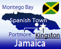 JAMAICA is a relatively well-known island country with English being the official language. Jamaica is south of Cuba and west of Haiti. The capital is Kingston, which is the largest city with almost 600,000 residents. The second most-populated city is Spanish Town, with a population greater than 145,000. The currency is the Jamaican Dollar, and its ISO 4217 currency code is JMD.
 HAITI (Haïti) is a French- and Creole-speaking country on the western side of Hispaniola, an island in the Caribbean Sea. Haiti is west of Dominican Republic and southeast of Cuba. The capital is Port-au-Prince, which is the largest city. The second largest city is Cap-Haïtien (Cap Haitien). Other communities in Haiti include Anse-à-Galets (on Gonâve island), Carrefour, Fort-Liberté, Gonaïves, Hinche, Jacmel, Jean-Rabel, Les Anglais, Les Cayes, Marigot, Pétionville, Port-de-Paix, Saint-Marc, and Verrettes. Haiti's main islands are Gonâve, Grande Cayemite, Tortue (also known as Tortuga, or Tortoise), and Vache (Cow). Haiti's currency is the Haitian Gourde, and its ISO 4217 currency code is HTG.
 Located in the eastern area of the Caribbean Sea, GRENADA is an island country including the main Grenada island and six islands that are part of the Grenadines island chain. Grenada is below St. Vincent and the Grenadines and north of Trinidad and Tobago. The capital is St. George's, which has approximately 30,000 inhabitants. Other towns in Grenada include Constantine, Gouyave, Grand Anse, Grenville, L'Anse aux Epines, Saint Paul, Sauteurs, Tivoli, and Victoria. The currency is the East Caribbean Dollar, and its ISO 4217 currency code is XCD. According to the International Union for Conservation of Nature (IUCN), Grenada has a total of 20 endangered and critically endangered species. More details are provided in my Grenada Endangered Species post.
 The DOMINICAN REPUBLIC is a country located on the eastern portion of the island Hispaniola. The Dominican Republic borders Haiti to the west and is located west of Puerto Rico. The capital is Santo Domingo, which has over 2 million inhabitants like Havana, Cuba. The currency is the Dominican Peso, and its ISO 4217 currency code is DOP. Lake Enriquillo (Lago Enriquillo) is the largest lake on any island in the Caribbean Sea. The saltwater lake is inhabited by crocodiles.
 DOMINICA is a single-island country in the Caribbean Sea located south of the Dominica Passage and north of the Martinique Passage. Dominica is north of Martinique and south of Guadeloupe - both are overseas regions belonging to France. Like Guadeloupe and Martinique, Dominica is in the middle of a curved strip of islands called the Lesser Antilles. The capital is Roseau, which has over 16,000 inhabitants. The currency is the East Caribbean Dollar, and its ISO 4217 currency code is XCD. A unique feature of Dominica is a boiling lake - specifically a flooded fumarole, or opening in the Earth's crust. The Boiling Lake of Dominica is situated west of La Plaine and about nine kilometers east of Roseau.
 CUBA is the largest island country in the Caribbean Sea. Cuba is north of the Cayman Islands and Jamaica and southwest of The Bahamas. According to Encyclopædia Britannica, Cuba’s population in the year 2020 was about 11,192,000 and was ranked 83rd among populations of the whole world’s countries, dependencies, and territories. The capital is Havana (La Habana), which has a population exceeding 2 million. The second largest city in terms of population is Santiago de Cuba.
Dual Currency System Ended
Cuba formerly had a two-currency system until May 2014. The controversial Convertible Peso (CUC) was pegged to the United State Dollar and was not used by most residents; instead, it was used mainly for foreign exchange and tourism purposes. Also, it was more valuable than the Cuban Peso (CUP). In May 2014, the government officially unified the currency; Cubans currently use the regular Cuban Peso.
Fidel Castro's Death
On Friday, November 25th, 2016, dictator Fidel Alejandro Ruz perished at the age of 90. Due to his Communist ideology, some people found it interesting that he died on Black Friday — a day that embodies capitalism! Leaders from around the world have expressed condolences or well wishes for the people of Cuba. In a statement, U.S. President Barack Obama (2008-2016) expressed condolences to family members and Cubans who are in mourning. President Obama also expressed optimism that the Cuba-United States relationship can positively grow in the days and years ahead. While there is a wide dichotomy of viewpoints about Fidel Castro, history will look back to note that the leadership of this arguably controversial, notorious, and passionate leader had an impact on Cuba and the world.

 BARBADOS is a single-island country in the Caribbean Sea. Nearby islands include St. Lucia (NW of Barbados), St. Vincent & the Grenadines (W), and Grenada (SW). Barbados is northeast of Venezuela. The capital is Bridgetown, which has over 96,000 inhabitants. The currency is the Barbados Dollar, and its ISO 4217 currency code is BBD.
 Situated along the Caribbean Sea's northernmost extent, THE BAHAMAS country is a well-known group of islands with English as the predominately-spoken language. Places that are near the Bahamas include the US state of Florida, Cuba, and the Turks and Caicos Islands. The capital is Nassau, which is located on the populated island of New Providence. The currency is the Bahamian Dollar, and its ISO 4217 currency code is BSD.
 ANTIGUA and BARBUDA is an island country that has two main islands (Antigua and Barbuda) and many smaller islands. Nearby islands include Guadeloupe (located south and southeast), Montserrat (southwest), and St. Kitts and Nevis (west). The capital is Saint John's, which has more than 24,200 inhabitants. According to Encyclopædia Britannica, Antigua and Barbuda's population in the year 2020 is about 98,100 and is ranked 201st among populations of the whole world’s countries, dependencies, and territories. English is the Caribbean island country's working language, while Leeward Caribbean English Creole (Antiguan and Barbudan) is a vernacular language used for communication. Antigua and Barbuda uses the East Caribbean Dollar.

Here are the Caribbean Sea Posts that I will write in the course of the Caribbean Run-Through:
Anguilla,
Antigua and Barbuda,
Aruba,
The Bahamas,
Barbados,
British Virgin Islands,
Cayman Islands,
Cuba,
Dominica,
Dominican Republic,
Grenada,
Guadeloupe,
Haiti,
Jamaica,
Martinique,
Montserrat,
Netherlands Antilles,
Puerto Rico,
Saint Barthélemy,
Saint Kitts and Nevis,
Saint Lucia,
Saint Martin,
St. Vincent and the Grenadines,
Trinidad and Tobago, and
US Virgin Islands.
Blog Content
● The author of this GeoFact of the Day Blog creates and curates original, authentic content and posts information based on established facts. Blog posts are not generated by artificial intelligence (AI) but published by the author.
● Content and image graphics from other sources are properly credited. Many geography facts are well-established and therefore do not belong to any one source, but occasionally a fact requires attribution/credit if it is unique and hard-to-find — for example, facts found from specific cultural, anthropological, geological, and scientific (etc.) research.
● I do not copy and paste from other websites. Therefore, all posts are original but may sometimes include information, links, and/or images from credited external sources. To use a GeoFact of the Day Blog image for your website or project, write a comment below a post — then I may approve your request.
● Feel free to offer comments, suggestions, and compliments on any post or page! You can be anonymous. Spam comments with non-relevant links will be deleted.
● Thanks for your loyal readership on the educational and reliable GeoFact of the Day Blog, in existence since 2008!


