Search for Posts, Maps, and Topics

1) The Congo Pedicle is a foot-like panhandle region in the southeastern corner of the DEMOCRATIC REPUBLIC OF THE CONGO and situated near ZAMBIA. The pedicle area features a national park known as Demalisques de Leshwe, possibly named after the genus (damaliscus) of which animal?
A — sloth
B — aardvark
C — antelope
D — penguin
2) True or false: There is an island named Komodo in INDONESIA.
3) The third highest mountain the world is Kangchenjunga, a Himalayan peak standing over 8,500 meters and 28,000 feet tall. Kangchenjunga is situated on the border between INDIA and what mountainous country flying a double pennant shaped flag?
A — ARGENTINA
B — BANGLADESH
C — SWITZERLAND
D — NEPAL
ANSWERS
Question 1:
C . . . . . antelope
Question 2:
True . . . . . it is home to the world-renown Komodo dragon!
Question 3:
D . . . . . Nepal
I am a landlocked South American country with over 7 million people living within my borders. My national capital, Asunción, sits not very far from the border of northeastern ARGENTINA. Other cities and communities that I have include Bella Vista, Caacupé, Caazapá, Ciudad del Este, Concepción, Encarnación, Filadelfia, Pilar, Rosario, San Pedro, Tacuatí, and Yhú. As the title of this post indicates, my flag has two different sides with a different circular emblem on each side. The seal on the flag’s “front” side includes a golden star and my official name: REPUBLICA DEL ________. The “back” or reverse side of my flag features a lion holding a liberty cap perched atop a pole; above the lion is a red banner inscribed with “PAZ Y JUSTICIA” (PEACE AND JUSTICE). What country am I?
A — ECUADOR
B — MADAGASCAR
C — PARAGUAY
D — SOLOMON ISLANDS
ANSWER
C . . . . . Paraguay
People all across ARGENTINA celebrated their country's Independence Day on Thursday, July 9th. Argentina achieved independence from Spain in 1816. Happy belated Independence Day!
The following produce and materials are major exports of ARGENTINA: chemicals, copper, corn, grapes, iron ore, lemons, manganese, meat, petroleum and gas, processed food, soybeans, steel, tea, tin, tobacco, vehicles, wheat, and zinc. According to the International Monetary Fund (data.imf.org), countries and territories buying and importing most of those exports in 2016 include Brazil (top importer), China, United States, Chile, India, Vietnam, Venezuela, Germany, Spain, Canada, Uruguay, the Netherlands, Algeria, Switzerland, Egypt, Indonesia, Paraguay, Italy, Malaysia, and Mexico.
 A total of nine sites of interest of special cultural and environmental significance in ARGENTINA are designated on UNESCO's World Heritage List. Four national parks listed as World Heritage Sites showcase Argentina's diverse climates and landscapes: dry desert areas in the extreme northwest and west-central regions, subtropical rainforests in the east and northeast, and mountainous terrain along the western border with Chile. The first Argentinian property to be inscribed on the list (1981), Parque Nacional Los Glaciares (Los Glaciers National Park) of southern and southwestern Argentina boasts breathtaking scenery of the Andes Mountains and multiple glacial lakes, include Lago Anita, Lago Argentino, and Lago Tannhauser. Inscribed three years later, northeastern Argentina's Iguazu National Park features mesmerizing waterfalls and a high biodiversity in a rainforest setting.
Parque Provincial Ischigualasto (Ischigualasto Provincial Park) and Parque Nacional Talampaya — combined into one heritage site called Ischigualasto/Talampaya Natural Parks — extend over 275,300 hectares, 2,753 square kilometers, and 1,063 square miles across the desert regions of northwestern Argentina's La Rioja and San Juan provinces. Argentina's newest inscribed property, the Qhapaq Ñan Andean road system (2014), is an important trade route extending across Argentina, Bolivia, Chile, Colombia, Ecuador, and Peru. These are Argentina's remaining heritage sites: Cueva de las Manos (amazing hand imprint cave paintings, as shown above), the Jesuit Block and Estancias of Córdoba, Jesuit Missions of the Guaraní Indians, Península Valdés, and Quebrada de Humahuaca valley.
Various countries have suns on their flags. They are ANTIGUA and BARBUDA, ARGENTINA, KAZAKHSTAN, KIRIBATI, KYRGYZSTAN, MALAWI, NAMIBIA, NEPAL, NORTH MACEDONIA (known as Macedonia or FYROM in 2015), The PHILIPPINES, RWANDA, and URUGUAY. Comprised of a main island and smaller islands, TAIWAN (Republic of China) is not exactly a country but it also has a sun on its flag. The sun on Taiwan's flag is featured in the top-left corner on top of a blue rectangle. The flags of BANGLADESH and JAPAN both feature a central red circle representing the sun. PALAU's yellow circle actually represents the moon!
Capital cities in all varieties of countries are often located next to or close to rivers and streams. Rivers facilitate trade, convenient transportation, beautification of cities, and recreation activities for residents and tourists. Almost every capital in South America straddles a major river. At the very least, every capital in the continent has rivers, streams, and canals flowing near or within them. In the text below, every country's name has a convenient link to their posts; these links open in new tabs or windows.
Buenos Aires, the capital of ARGENTINA
― Río de la Plata and Riachuelo (Río de la Matanza)
La Paz, one of the capitals of BOLIVIA
― Río Choqueyapu and Río Seco
Sucre, the other capital of Bolivia
― Río Cachimayu
Brasília, the capital of BRAZIL
― Ribeirão Taguatinga (stream) and Río São Bartolomeu
Santiago, the capital of CHILE
― Canal San Carlos (manmade canal), Río Maipo, and Río Mapocho
Bogotá, the capital of COLOMBIA
― Río Bogotá and Río Tunjuelo
Quito, the capital of ECUADOR
― Río San Pedro
Cayenne, the capital of FRENCH GUIANA (overseas territory)
― Canal LeBlond (manmade canal) and Rivière des Cascades
Georgetown, the capital of GUYANA
― Demerara River and east of Essequibo River
Asunción, the capital of PARAGUAY
― Arroyo Leandro Sosa (stream) and Río Paraguay
Lima, the capital of PERU
― Río Lurín, Río Rímac, and south of Río Chillón
Paramaribo, the capital of SURINAME
― Suriname River (Surinamerivier in Dutch)
Montevideo, the capital of URUGUAY
― Arroyo Miguelete and Arroyo Pantanoso (streams north and northwest of Montevideo)
Carácas, the capital of VENEZUELA
― Quebrada Caroata (stream) and Río Guaire
Below, simply match the past president with the correct country. Argentina and Mexico both have two answer choices. Answers are found multiple spaces down below. Of course, try not to consult the Internet or any other sources to see if you have great knowledge or guessing skills about these questions!
1. Juscelino Kubitschek de Oliveira was the 21st president (1956-1961) of __________.
2. Bernardino Rivadavia was the 1st president (1826-1827) of __________.
3. José de San Martin was the 1st president (1821-1822) of __________ and encouraged the independence of Argentina from Spain.
4. Jean-Pierre Boyer was the 2nd president (1818-1843) of __________, one of two countries on the island of Hispaniola.
5. Raúl Alfonsín was the 46th president (1983-1989) of __________ and was the country's first democratically elected president after a previous military government.
6. Miguel Alemán was the 46th president (1946-1952) of __________.
7. Fulgencio Batista was the 9th president (1940-1944) and the 12th "president" (basically a dictator from 1952-1959) of __________.
8. Pedro Santana was the 1st (1844-1848), 4th (1853-1856), and 8th (1858-1861) president of the __________, the other country on the island of Hispaniola.
9. Lázaro Cárdenas was the 44th president (1934-1940) of __________.
Answers
1. Brazil
2. Argentina
3. Peru
4. Haiti
5. Argentina
6. Mexico
7. Cuba
8. Dominican Republic
9. Mexico
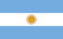
A country which fought alongside Brazil and Uruguay against Paraguay in the War of the Triple Alliance (1864-1870), ARGENTINA adopted the current flag while it fought in a previous war to earn its independence from Spain in 1812. The top and bottom horizontal stripes are sky blue, which has several possible meanings. These blue stripes could represent Argentina's Rio de la Plata river, the Atlantic Ocean, and/or clear blue skies. The Sun of May, which is Argentina's national emblem, sits in the center on top of the white horizontal stripe. There are various subtle design variations of the Sun of May, although the Flagpedia.net flag depicted below shows a common design. The flag's size ratio is 9:14 according to Vexilla Mundi. Vexilla Mundi also shows that the Argentinean flag from 1516 to 1812 had white and red colors, while the flags of 1819-1820 and 1829-1861 had dark blue stripes instead of sky blue ones. Also, two previous flag designs from the years 1835-1850 and 1850-1861 featured Phrygian caps, representing liberty and freedom.
As of June 12th, 2014, the IUCN Red List of Threatened Species™ lists over 90 endangered and critically endangered species in ARGENTINA (learn more about Argentina with my post). The Red List declares two species in Argentina as extinct: the Red-Bellied Gracile Mouse Opposum, extinct since 1962, and the Rhantus orbignyi beetle, extinct since 1996. Three snail species - Aylacostoma chloroticum, Aylacostoma guaraniticum, and Aylacostoma stigmaticum - have been declared extinct in the wild because of the Yacyretá dam project on the Paraná River. The Senecio leucopeplus wildflower is also extinct in the wild but fortunately conserved in Buenos Aires' Pillahuincó Botanical Garden.
* Citation about the snail species:
Mansur, M.C.D. (Mollusc Specialist Group) 2000. In: IUCN 2014. IUCN Red List of Threatened Species. Version 2014.1. Downloaded on 12 June 2014.
* Citation about Senecio leucopeplus:
de Villalobos, A. (Dep. Biología Bioquímica y Farmacia, UNS, Bahia Blanca, Argentina) 2008. Senecio leucopeplus. In: IUCN 2014. IUCN Red List of Threatened Species. Version 2014.1. Downloaded on 12 June 2014.
Forming the southern triangular wedge of South America, the countries ARGENTINA, CHILE, PARAGUAY, and URUGUAY have a variety of peoples and languages - too many to list all of them on a blog post! Therefore, this post is focused on official languages and other widely spoken languages. In all four countries, Spanish is the official language.
Argentina: Other widely spoken languages include Quechua, Mapuche, English, Italian, German, and French.
Chile: Other languages include Araucanian, Quechua, and Mapuche.
Paraguay: Guaraní is an official language alongside Spanish. Two of Paraguay's many languages include Guaná and Sanapaná.
Uruguay: Portuñol/Brazilero (Portuguese-Spanish) is another spoken language.
Today was a rainy day in VATICAN CITY, but that did not prevent thousands from around the world waiting patiently outside to meet the new pope, who was revealed at the balcony of Saint Peter's Basilica overlooking Saint Peter's Square. Hailing from ARGENTINA, the South American country located east of Chile and west of the Atlantic Ocean, the new pope is Jorge Mario Bergoglio. He now has the name Pope Francis I and is the successor to Pope Benedict XVI, who recently resigned. There are more than 30 million Roman Catholics in Argentina. It was neat to see flags of many different countries waving proudly on the television, and I could not imagine how magical the experience of actually being there is! The countries I saw represented in flags include Angola, Argentina, Australia, Brazil, Chad, Czech Republic, East Timor, France, Malta, Mexico, Poland, Slovenia, Spain, the United States, Vatican City, Venezuela, and more. The first tweet on Pope Francis I's Twitter page (which formerly belonged to several tweets of Pope Benedict XVI) announced his election to the highest honor of the Catholic tradition.
March 17th update: It was written on March 13, 2013, but has been deleted several days afterwards. It was as follows: HABEMUS PAPAM FRANCISCUM — Pontifex (@Pontifex). Below is the second Twitter message (written March 17th):
Here are the 10 largest countries in area:
1) Russia
2) Canada
3 or 4) * United States of America
3 or 4) * China
5) Brazil
6) Australia
7) India
8) Argentina
9) Kazakhstan
10) Algeria — was formerly Sudan until South Sudan separated from Sudan
*** Visit this wikipedia page for the whole list of countries by area.
* The areas of the USA and China may vary depending on what is included and excluded from the total area; both total areas are similar.
 One of the southernmost countries in the world, ARGENTINA is located in the southern region of South America. Argentina's bordering countries are Bolivia to the north and northwest, Brazil to the northeast, Chile to the west, Paraguay to the north, and Uruguay to the east. Argentina also borders the South Atlantic Ocean. Argentina's currency is the Argentinean Peso, and its ISO 4217 currency code is ARS.
● ● ● ● ● People and Places ● ● ● ● ● According to Encyclopædia Britannica, Argentina's population in the year 2020 is about 43,377,000 and is ranked 30th among populations of the whole world’s countries, dependencies, and territories. Argentina's capital is Buenos Aires ("good air"), which is located west of the Río de la Plata ("river of silver") and the Atlantic Ocean. Buenos Aires is also located southwest of Uruguay. As of 2015, 3 million residents live in Buenos Aires. Other major cities throughout Argentina include Córdoba, La Plata, Mendoza, Rosario, Salta, Tucumán, and Ushuaia. A majority of Argentinians — anywhere from 60% to 97%, depending on the information source and definition — have ancestral heritage of European and non-European Caucasian people. At least 10% of residents are of partial or whole indigenous ancestral descent. Native indigenous groups in Argentina include the Aymara, Guaraní, Mapuche (Mapudungu), Quechua, Qulla, and Wichí people. Over 95% of Argentinians speak Spanish (official language), about 1% can speak German, and other residents speak indigenous languages. 92% of religious Argentinians are Roman Catholic, followed by Islam at about 2% and Judaism at 1.3%.
Post Link: UNESCO World Heritage Sites in Argentina
● ● ● ● ● Land and Water Features ● ● ● ● ● Ushuaia, the southernmost city in the world, is located on Isla Grande de Tierra del Fuego, the triangular Tierra del Fuego archipelago's largest island. Tierra del Fuego translates to "land of fire," named by Ferdinand Magellan when he discovered smoke rising from campfires built by native islanders. The island's western section belongs to Chile. East of this island is Isla de los Estados, which forms the archipelago's eastern extent. Other islands in this archipelago — including Isla Clarence, Isla Dawson, Isla Gordon, Isla Hoste, and Isla Navarino — belong to Chile. With a total length of about 4,880 kilometers and 3,032 miles, Paraná River is South America's second-longest river and the longest river flowing through Argentina. Other rivers include Chico, Colorado, and Uruguay.
Standing near the Argentina-Chile border in Mendoza Province, Argentina's highest point is Mount Aconcagua (Cerro Aconcagua). Aconcagua stands about 6,960 meters and over 22,830 feet in elevation within the Southern Andes mountains. Other mountains — some of which are also volcanoes — which straddle the country's western border include Cerro Bonete, Llullaillaco (also a historically active volcano), Cerro Mercedario, Monte Pissis (also an extinct volcano), Ojos del Salado (also a stratovolcano), and Volcán Tupungato (also a stratovolcano).

Blog Content
● The author of this GeoFact of the Day Blog creates and curates original, authentic content and posts information based on established facts. Blog posts are not generated by artificial intelligence (AI) but published by the author.
● Content and image graphics from other sources are properly credited. Many geography facts are well-established and therefore do not belong to any one source, but occasionally a fact requires attribution/credit if it is unique and hard-to-find — for example, facts found from specific cultural, anthropological, geological, and scientific (etc.) research.
● I do not copy and paste from other websites. Therefore, all posts are original but may sometimes include information, links, and/or images from credited external sources. To use a GeoFact of the Day Blog image for your website or project, write a comment below a post — then I may approve your request.
● Feel free to offer comments, suggestions, and compliments on any post or page! You can be anonymous. Spam comments with non-relevant links will be deleted.
● Thanks for your loyal readership on the educational and reliable GeoFact of the Day Blog, in existence since 2008!


