Search for Posts, Maps, and Topics

 Officially known as the Republic of Zimbabwe, ZIMBABWE is a landlocked country located in Southern Africa. Zimbabwe borders five countries: Botswana located to the southwest, Mozambique to the east, South Africa to the south, and Zambia to the north. Zimbabwe almost borders Namibia to the west. Along the Zimbabwe-Zambia border, the country possesses part of Lake Kariba, the Zambezi River, and the magnificent Victoria Falls. Zimbabwe’s former currency was the Zimbabwean Dollar, which had an ISO currency code of ZWL. Due to hyperinflation, Zimbabweans were and still are using other currencies to complete transactions. In June 2015, the Central Bank officially withdrew the currency from circulation. Zimbabwe is the world’s last country in alphabetical order!
● ● ● ● ● People and Places ● ● ● ● ● Over 11.652 million residents live in Zimbabwe, while 1,190,000 urbanites live in the national capital: Harare. Other major cities include Bulawayo (population: 622,000), Chitungwiza (275,000), Gweru (125,000), Hwange, Masvingo, Mutare (132,000), and Shurugwi. While Zambia is known for its diverse variety of ethnic groups, Zimbabwe is predominantly shared between Shona (over 80%) people, Ndebele (14%) people, and several other minority groups. About twenty-one major languages are used for communication — including two (Barwe and Tsoa) that are facing a threatened existence in the future. Languages include Chichewa, Dombe, Kalanga, Kunda, Lozi, Manyika, Nambya, Ndau, Ndebele, Shona, Tonga, Tswana, and Venda. Zimbabwe's literacy rate is relatively high (84%) in Africa. About 70% of religious Zimbabweans are Christians and 0.75% are Muslims. About 30% of Zimbabweans adhere to native beliefs and customs.
Great Zimbabwe (southeast Zimbabwe) and Dhlo-Dhlo (south-central Zimbabwe) are two ancient Shona civilization sites with still-standing stone walls and towers. Standing about 10.05 meters and 33 feet tall in Great Zimbabwe, the prominent conical tower is attached to walls of the Great Enclosure — known as the largest pre-colonial structure in Sub-Saharan Africa. Another ancient site and tourist attraction is located at Khami, a current UNESCO World Heritage Site and ancient capital of the Kingdom of Butua — organized by the ancestors of Kalanga (Shona-related) people. Zimbabwe’s national parks include Chewore Game Preserve (north), Chizarira NP (northwest), Gonarezhou NP (southeast), Hwange NP (west), Kazuma Pan (west), Mana Pools NP (north), Matabo NP (southwest), Matusadona NP (NW), Mtarazi Falls NP (east), and Zambezi NP (Zimbabwe’s western tip).
● ● ● ● ● Land Features ● ● ● ● ● Zimbabwe’s major waterfalls are on opposite sides of the country. People can find the Mtarazi Falls and Pungwe Falls in eastern Zimbabwe, while tourists would want to visit western Zimbabwe to witness the world-famous Victoria Falls. There’s more than waterfalls in Zimbabwe! Non-water land features include the northern Chinhoyi Caves, northwestern Chizarira Hills, central Mafungabusi Plateau, southern Mateke Hills, eastern Mavuradonha Mountains (near NW Mozambique), and northern Zambezi Escarpment. The Chinhoyi Caves are located about 150 kilometers northwest of Harare, while the Zambezi Escarpment is further north and runs westward into Zambia. Located in eastern Zimbabwe near Mozambique, Mount Nyangani is Zimbabwe's highest peak and stands 2,592 meters and 8,504 feet in elevation. Nyangani is comprised of harder dolerite and softer sandstone.
This post was updated with more information in September 2016. GeoFact of the Day’s map of Zimbabwe was designed in December 2022.

● ● ● ● ● People and Places ● ● ● ● ● Based on the GeoFact of the Day Blog’s 2016 estimate, Zambia’s total population is approximately 12,060,000 and growing. Located in south-central Zambia less than 100 kilometers away from Zimbabwe, the capital and most-populated city is Lusaka with about 982,000 residents. Other Zambian cities include Chingola (170,000), Choma, Kabwe (population: 168,000), Kasama, Kitwe (247,000), Livingstone, Lundazi, Mbala, Ndola (377,000), Serenje, and Zambezi.
Zambians culturally identify themselves in over 70 ethnic groups of people — including the Bemba, Kaonda, Lozi, Ngoni, and Tonga ethnicities. While English is used as an official language by some citizens and for government purposes, Zambians speak about 70 native ethnic languages, many of which correspond to the namesake ethnic tribe. Major native languages include Bemba, Kaonda, Lozi, Lunda, Luvale, Nyanja, and Tonga. At least one-half of religious citizens are Christian, while one-fourth of people are Hindu and Muslim adherents.
Protected and publically accessible national parks are scattered throughout the country. Parks in the northeastern “panhandle” include Isangano NP, Kasanka NP, Lavushi-Manda NP, Luangwa NP (split into north and south sections), Lukusuzi NP, Lusenga NP, Mweru-Wantipa NP, and Nsumbu NP. Other national parks include Blue Lagoon and Lochinvar national parks (south-central Zambia), the large Kafue NP (west-central Zambia), Liuwa Plain NP (west), Lower Zambezi NP (southeast), Sioma Ngwezi NP (southwest), and West Lunga NP (northwest).
● ● ● ● ● Land Features ● ● ● ● ● Aquatic and physical features in northern and eastern Zambia include the Bangweulu Swamp, Chisimba Falls, Johnston Falls, Lake Bangweulu with Mbabala island, Lake Mweru with Kilwa island, Muchinga Mountains, and Sunzu mountain (elevation: 2,067 meters). Zambians and tourists alike enjoy dramatic cliff views of the Wonder Gorge, located in east-central Zambia along the Lusemfwa River. About 150 kilometers west lies the Lukanga Swamp, home to various endangered species and undoubtedly many pesky mosquitoes! Kuyamba Hills are northwest of the swamp, while the Mufulwe Hills are northeast of Wonder Gorge.
What is the highest point in Zambia, you might (or might not) ask? Well, the answer is unfortunately not 100% clear. On the border between eastern Zambia and western Malawi, Mwanda Peak (elevation: about 2,150 meters, 7,050 feet) is known as the Zambia border's highest point. Near the town of Mkushi in north-central Zambia, Mount Mumpu (1,950 meters, 6,400 feet) is known as the country's highest free-standing mountain. Interestingly, one of the routes up Mt. Mumpu traverses through one of Southern Africa's largest bat caves. Ultimately, though, the highest point designation likely belongs to Mafinga Central (according to Peakbagger.com and other sources) — boasting an elevation of 2,339 meters and 7,674 feet. Could there be an even higher point in Zambia somewhere? That could be a mystery yearning to be solved!
The ridge-like Zambezi Escarpment protrudes from southern Zambia into northern Zimbabwe. Its location is north of Lake Kariba, which stretches along the southern border with Zimbabwe. West and east of Lake Kariba, the Zambezi River stretches completely along the Zambia-Zimbabwe border. Before reaching southern Zambia, Zambezi begins in eastern Angola (location of its headwaters), then flows southward past the town of Zambezi and eventually reaches the borders of Namibia and then Zimbabwe. Arguably the most popular tourist attraction in Zambia, the Victoria Falls are along the Zambezi river in southwestern Zambia, near Zimbabwe’s western tip (see map). Other waterfalls are highlighted in the GeoFact of the Day Blog’s Waterfalls of Zambia post (↗).
This post was comprehensively updated on August 25th, 2016.
The map of Zambia was added on June 18th, 2017.

 Also known as Umbuso weSwatini in the Swazi (siSwati) language and formerly known as Swaziland, the Kingdom of ESWATINI (alternate spelling: eSwatini) is a relatively small country located in Southern Africa. Since 1986, King Mswati III is the current leader — as of 2023 — of Eswatini's absolute monarchy. There are 2 bordering countries: Mozambique to the north and South Africa to the west. There are two capitals: Mbabane (pronounced "Mmm Ba Ba Nay") is the administrative capital, while Lobamba is the royal and legislative capital. The currency is the Swazi Lilangeni, and its ISO 4217 currency code is SZL.

Map Credit: © Maps of the World (mapsofworld.com).
Refresh the page if map doesn't appear right away.
Compared to other African countries, SOUTH AFRICA has a more financially prosperous economy. The Netherlands and British Empire colonized South Africa, and the country achieved independence in 1961. There are 6 bordering countries: Botswana, Lesotho, Mozambique, Namibia, Swaziland, and Zimbabwe. South Africa also borders the Indian Ocean and the South Atlantic Ocean. There are 3 capitals, each for different purposes. Bloemfontein is the judicial capital, Cape Town is the legislative capital, and Pretoria is the executive capital. The currency is the South African Rand, and its ISO 4217 currency code is ZAR.

● ● ● ● ● People and Places ● ● ● ● ● While about 30 languages are spoken throughout the country, Namibia's sole official language is a non-native language: English. Due to former colonization by Germany, German is still spoken among some residents. Native languages include Afrikaans, Chokwe, Diriku, Fwe, Haillom, Herero, Jul'hoan, Khoekhoe, Kwambi, Kwangali, Kwanyama, Luyana, Nama, Nyemba, Yeyi, and Zemba. The capital and most-populated city is Windhoek. Other Namibian cities and communities include Berseba, Lüderitz, Okahandja, Rehoboth, and Swakopmund. Namibians use the Namibian Dollar, and its ISO 4217 currency code is NAD.
● ● ● ● ● Land Features ● ● ● ● ● Namibia is located east of the South Atlantic Ocean and straddles the Tropic of Capricorn. With its iconic, towering sand dunes, the Namib Desert is situated immediately east of Skeleton Coast off of northwestern Namibia and Diamond Coast off of southwestern Namibia. The Kalahari Desert in eastern Namibia extends into western Botswana and northern South Africa. Standing at 8,550 feet or about 2,606 meters in western Namibia, Brandberg is the country's highest mountain. Also known as the King's Stone, Königstein (or Konigstein) is Brandberg's highest point. No point in Namibia is lower than the Atlantic sea level at zero feet and meters.
I designed and posted the map of Namibia in December 2020.

 Colonized by Portugal until June 25th, 1975, MOZAMBIQUE is a country in southeastern Africa located west of the Indian Ocean. There are 6 bordering countries: Malawi to the north, South Africa to the southwest, Swaziland to the south and southwest, Tanzania to the north, Zambia to the northwest, and Zimbabwe to the west. Mozambique's official language is Portuguese. The capital is Maputo, which is located in southern Mozambique. Other cities in the country include Beira, Chimoio, Inhambane, Nampula, and Xai-Xai. Mozambique's currency is the Mozambican Metical, and its ISO 4217 currency code is MZN.
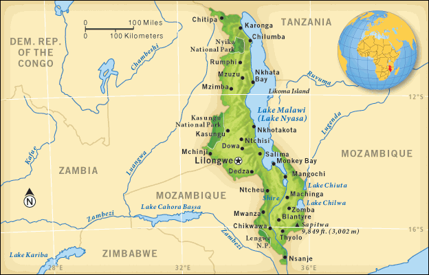
 MALAWI is a slender country formerly known as Nyasaland, situated in Southeastern Africa. There are 3 bordering countries: Mozambique, Tanzania, and Zambia. Malawi also borders Lake Nyasa, the 3rd largest lake in Africa. The capital and most-populated city is Lilongwe. The currency is the Malawian Kwacha, and its ISO 4217 currency code is MWK.
 ● ● ● ● ● Table of Contents ● ● ● ● ●
Intro and General Facts ● People and Places ● Land Features ● Volcanoes
Famous for its biodiversity, vanilla orchids, paradise-like coastlines, and lemurs, the Republic of MADAGASCAR is a southeast African island country that achieved independence from France in June 26th, 1960. The island country is officially known as Repoblikan’i Madagasikara in the Malagasy language and République de Madagascar in the French language; Malagasy Republic is an acceptable name as well. The Indian Ocean is east of Madagascar, and the north-south Mozambique Channel separates Madagascar's west coast from mainland Africa. While Madagascar is the fourth largest island in the world, more than a dozen smaller islands are also included within the country's territory.
Neighboring countries include Comoros and Tanzania to the northwest, Mauritius to the east, Mozambique to the west, and Seychelles to the northeast. Madagascar's world-renown vanilla provides an orchid-based alternative to the synthetic vanilla compounds found in most processed food today. The extraction of this vanilla currently requires a labor-intensive pollination process by hand. Some other exports for trade (↗) are cinnamon, clothing, coffee, gemstones, and seafood. The Malagasy Ariary is Madagascar's currency, and its ISO 4217 currency code is MGA. Among the world's few remaining non-decimal currencies is the Ariary, as 5 iraimbilanja (francs) equal 1 ariary. The former Malagasy Franc — subdivided into 100 centimes — was used for transactions alongside the Ariary until 2005.
● ● ● ● ● People and Places ● ● ● ● ● The Hammond World Atlas (6th Edition) reports the total population in Madagascar as 20,653,556 in 2011. In close comparison, nearby Mozambique had 21,669,278 residents in 2011. The capital and largest city of Madagascar is Antananarivo. Its metropolitan area is home to over 2.6 million residents (2015 estimate). Other Malagasy cities include Ambatondrazaka, Amboasary, Antsirabe, Betioky, Farafangana, Ifanadiana, Iharan̈a (Vohemar), Mahajanga, Maintirano, Tsiroanomandidy, and Vohipeno. Popular places all across the country to visit include the Ambaro Ranch, Analakely Market in Antananarivo, Antsirabe Cathedral, Avenue of the Baobabs, Fort Manda, Lemurs' Park, Le Palais de la Reine (Queen's Palace) and the Rova royal-palace complex, Les Trois Baies (The Three Bays) beach, Lokaro Beach, Lokobe Nature Special Reserve, pirate cemetery on the island of Boraha, Pirate Museum in Antananarivo, Tsimbazaza Zoo, and Tsingy de Bemaraha Strict Nature Reserve.
Malagasy and French are the two official languages, and approximately 90% of the population shares a Malagasy ethnic heritage according to Encyclopedia Britannica (↗). The Ethnologue (↗) linguistic information website notes that Malagasy Sign Language is utilized by anywhere from 110,000 to 170,000 people in the year 2014. Fourteen main languages are used for communication, eleven of which are grouped within the Malagasy macrolanguages. Most of the languages' names correspond to their respective ethnic populations. The microlanguages are Antankarana, Bara, Masikoro, Northern Betsimisaraka, Plateau, Sakalava, Southern Betsimisaraka, Tandroy-Mahafaly (Antandroy), Tanosy, Tesaka, and Tsimihety. One population not aforementioned in this paragraph is the Merina people; they are scattered around the country and are "the largest and most dominant of the groups," according to Encyclopedia Britannica.
The Merina, Betsileo, Bezanozano, Sihanaka, Tanala, and Zafimaniry populations communicate with dialects grouped under the Malagasy Plateau language umbrella. Some ethnic populations have nicknames assigned to them, although Encyclopedia Britannica notes that some of these nicknames are not true to their respective indigenous cultures — but rather hasty carryovers from the time when France colonially ruled Madagascar. Nevertheless, some of these nicknames — listed in the table below — give subtle insight into the daily lives and habitats of these people. About 50% of Malagasy citizens are Christians, followed by believers in folk religions and traditions (45%), Muslims (2%), Bahá'í believers (0.1%), and Hindus (0.06%).
| Antaifasy | "people of the sand" |
| Antaimoro | "people of the banks" |
| Antakarana | "people of the rocks" |
| Antandroy | "people of the thorn bush" |
| Antanosy | "people of the island" |
| Betanimena | "people of the red soil" |
| Betsileo | "the invincible multitude" |
| Betsimisaraka | "the inseparable multitude" |
| Bezanozano | "those of many small plaits" or
"those with many-braided hair" |
| Mahafaly | "those who make taboos" |
| Merina (Imerina) | "elevated people" |
| Sakalava | "people of the long valley" |
| Sihanaka | "people of the lake" |
| Tanala | "people of the forest" |
| Tsimihety | "those who do not cut their hair" |
● ● ● ● ● Land Features ● ● ● ● ● A mountain called Maromokotro is the highest point in Madagascar. Specifically, Maromokotro stands 2,876 meters and 9,436 feet high in elevation. This and other mountain peaks combine to form the Tsaratanana Massif. Several other notable mountain peaks throughout the country include Boby (2,658 meters), Tampon Ambohitra (1,475 meters), and Tsiafajavona (2,643 meters). The north-to-south Angavo Escarpment forms a ridge parallel to the eastern coastline, demarcating a transition between coastal lowlands and interior uplands. Smaller land features from the north to south in the western half of Madagascar include the Ikahavo Plateau, Cliff of Bongolava uplands, Bemaraha Plateau, Makay Massif, Isalo Massif, and Mahafaly Plateau. Onward to the eastern half of Madagascar, predominant land features from north to south include the Tsaratanana Massif, Analamaitso Plateau, Ankaratra Massif, Andringitra Mountains, Manamby Mountains, Beampingaratra Ridge, and Androy Plateau.
Transitioning from inland features to the peripheries of Madagascar, the mountainous and hilly terrain in interior areas make way for coastal landmasses of various shapes and sizes along the coast. Jutting southward from the towns of Antalaha and Maroantsetra toward Antongila Bay is the Masoala Peninsula (↗) (Saikanosin' Masoala), a northeastern Madagascar wedge of land visible on the GeoFact of the Day Blog map above. The smaller-scale land feature located at the tip of Masoala Peninsula is Tanjona Masoala. Tanjona translates from Malagasy into English as cape, while Saikanosin' translates to peninsula. Saikanosin' Ambato, Saikanosin' Ampasindava, Tanjona Ankatafa, Tanjona Bobaomby, Tanjona Makamby, Saikanosin' Orontany (Androntany), Tanjona Vilanandro, and Tanjona Vohilava are other prominent capes and peninsulas along Madagascar's craggy northern and northwestern coast. Also known as Cape Ambre in English or Cap d'Ambre in French, Tanjona Bobaomby is shaped like a northward arrow and is therefore fittingly the northernmost point of mainland Madagascar.
Identified as the country's largest bay, Antongila Bay is approximately 3,154 square kilometers and 1,218 square miles wide in area. A smaller but still-substantial bay at 175 square kilometers and 68 square miles in geographic area is Antsiran̈ana Bay, aptly located near the city of Antsiran̈ana close to the country's northernmost tip (Tanjona Bobaomby). The Ampangalana (Pangalanes) Canal provides a 645-kilometer (401-mile) long transportation route through natural rivers, altered waterways, and artificial lakes in close proximity to the eastern coastline. Ampangalana Canal is east of the aforementioned Angavo Escarpment and Cliff of Angavo. The following communities benefitting from this canal are listed in order from north to south: Mahavelona (near the canal's starting point), Nosibe, Toamasina, Andovoranto, Vatomandry (nickname: "sleeping rocks"), Mahanoro, Masomeloka, Nosy-Varika ("lemur island"), Mananjary, Manakara, Vohipeno, and Farafangana (near the canal's terminus). Six of these towns and cities are featured on the map above, giving you an idea of how close this canal really is to Madagascar's east coast and Indian Ocean.
● ● ● ● ● Volcanoes ● ● ● ● ● Madagascar boasts more than mountains, cliffs, massifs, and plateaus; the country can say it possesses volcanoes as well. Madagascar's volcanoes are dormant rather than active, and information about past eruptions is non-existent or inconclusive for most of those. Further described below, these are the volcanic fields containing at least several volcanic features: Ambre-Bobaomby (near the country's northern tip), Ankaizina (north), Itasy (central), and Vakinankaratra (Ankaratra) (east-central).
Sitting on the Ambre Massif, Ambre-Bobaomby has crater lakes and relatively new volcanic cones. According to the Smithsonian Institution's Global Volcanism Program (↗), 51,246 people live within 30 kilometers (18.6 miles) of the Ambre-Bobaomby volcanic field. Ankaizina contains cinder cones and lava domes and was "active until the very recent Quaternary" geologic period. 41,916 people live within 30 kilometers of the Ankaizina volcanic field. Occasionally the epicenter for earthquakes, Itasy features craters and scoria cones as well as the following lava domes: Ambohibe, Ampary, Angavo, Ingilofotsy, and Kitia. Named scoria cones include Ambohimalala, Ambohitritainerina, Ambohitrondry, Andranojavatra, Kassijie (Kassigie), Kitombold, Matiankanina, and Tsifajavona. Itasy's two major craters are Andranoratsy and Andranotoraha. Geologists, seismologists, volcanologists, and related scientists purport that there were at least two Holocene eruptions at Itasy based on radiocarbon dating of geologic materials: 6,050 B.C. and also 8,031 B.C. (give or take 139 years).
Nosy Be (Nossi Be), Madagascar's second-largest island after the mainland Madagascar island, is rimmed by a cluster of cinder cones and crater lakes. Nosy Be's volcanic features contain foidite, basalt, picrobasalt, and rhyolite. About 62,000 inhabitants of Nosy Be and surrounding areas live within 30 kilometers of these features. Cinder cones with basanite, craters, fissure vents, and lava domes with trachyte form the landscape of the Vakinankaratra volcanic field. Named volcanic features at Vakinankaratra include Amboniloha (cone), Ampasimihaiky (cone), Andraikiba (crater), Iavoko (cone), Ifasina (cone), Itavo (cone), Ivohitra (cone), Tramponga (cone), Tritriva (cone), and Tritrivakely (crater). The following list details the dominant rock types of each volcanic field: basalt and picrobasalt at Ambre-Bobaomby and Ankaizina; basanite, tephrite, and trachybasalt at Vakinankaratra; foidite at Nosy Be; and trachyte and trachydacite at Itasy.
This post was updated with more information on March 17th, 2019. The map of Madagascar was uploaded to this post on February 27th, 2019.

● ● ● ● ● People and Places ● ● ● ● ● Lesotho's political history since independence fluctuated between fledgling democracy and authoritarian militarism. In recent years, the constitutional monarchy strived to build on its democratic functions but with several setbacks — including riots and coup d'états, one of which is mentioned in the "Prime Minister's Dilemma" section below. Now let us focus on the positive; a sort of tradition for Lesotho is that newly elected prime ministers may receive a copy of the Constitution as a symbolic peaceful transfer of power. For example, Moeketsi Majoro was sworn into office on Wednesday, May 20th, 2020 and received a constitutional copy from predecessor Prime Minister Tom Thabane. The national capital of Lesotho is Maseru, which has at least 200,000 residents. Other cities include Hlotse (Leribe), Mafeteng (population: over 60,000), Maputsoe (Maputsoa) near Ficksburg, Mohale's Hoek, Moyeni (Quthing), Pitseng, and Teyateyaneng; smaller communities include Bokong, Butha-Buthe, Foso, Libono, Mokhotlong, Patlong, Qacha's Nek, Rafolatsane, and Thaba-Tseka. In regards to administrative divisions, Lesotho is divided into ten districts. A map and information of Lesotho's districts are featured in this GeoFact of the Day post (↗).
Interesting places to see and visit throughout the country include the Afriski Mountain Resort, Maletsunyane Falls, Maloti Mountains, Sani Pass, Gates of Paradise Pass, Thaba-Bosiu National Monument, Sehlabathebe National Park, Liphofung Caves, Ha Kome Cave Houses, Basotho Hat Shop (Maseru), Morija Museum & Archives, Lesotho Sun Casino, and several locations for dinosaur footprints. Lesotho's official languages are English and Sesotho (Southern Sotho). Other major languages for written and spoken communication include Phuthi (Sephuthi), Xhosa, and Zulu. About 90% of the Basotho people are Christians, followed by indigenous believers and Bahá'í Faith worshippers.
● ● ● ● ● Land Features ● ● ● ● ● Lesotho's rugged terrain and high elevation is thanks to the Drakensberg mountain range along the southeast border and the lower Maloti range in the northwest. The highest point in Lesotho, Thabana Ntlenyana, is the highest peak in Southern Africa as well. Commonly called the Senqu River in Lesotho, the Orange River winds its way for about 528.43 kilometers and 328.35 miles through southern and eastern Lesotho. The map below shows the river's twisty path from one end of the country to another, cutting through steep-cliff valleys all the way from its source in the northeast to the Lesotho-South Africa border in the southwest. Another major river — Caledon, also locally known as Mohokare — forms along the northwestern and northern border. Lesotho is home to two of southern Africa's largest hydroelectric dams: Katse and Mohale. Both located in north-central Lesotho, these dams transport water to South Africa and generate electricity for most of Lesotho. Other dams (see the second map below) include Mashai, Matsoku, Ntoahae, and Tsoelike.


● ● ● ● ● The Prime Minister's Dilemma, 2014-15 ● ● ● ● ● Touted for hosting one of Africa's few democratic elections in 2012, Lesotho's citizens elected Tom Thabane to be their prime minister and leader of a coalition government with three main parties, unseating 14-year prime minister Pakalitha Mosisili. The relatively stable political period Lesotho enjoyed took an unstable turn in Lesotho's winter (Northern Hemisphere's summer) in the year 2014. Thabane suspended parliament in June 2014 to be cautious of a potential coup d'état from the Lesotho Congress for Democracy party, led by Mothetjoa Metsing. In August, Thabane fled to South Africa for safety, fearing a deadly coup d'état from military leaders as well as a military takeover of important police buildings. After mediation of the kerfuffle made possible by the Southern African Development Community intergovernmental organization, Thabane and King Letsie III dissolved the parliament in December and announced a new election date on February 28th, 2015. Mosisili became prime minister once again after earning less than 1% more votes than Thabane.
This post was comprehensively updated with more info on August 10th, 2017.
 COMOROS (Komori in the Comorian language) is an island country in southeastern Africa and surrounded by the Indian Ocean waters. The country is located about 80 kilometers northwest of Mayotte (Mayotte post link), an overseas territory of France. There are 3 major islands that make up Comoros: Njazidja (Grande Comore or Ngazidja), Ndzwani (Anjouan), and Mwali (Mohéli). Comorian residents speak Comorian, Arabic, and French, which are the country's official languages. Within Comorian are three main dialects, each of which are spoken mostly on the particular island it is named after: Mwali, Ndzwani, and Ngazidja. The vast majority of Comorian residents adhere to the tenets of Islam. The capital is Moroni, which is located on Njazidja island. Other communities include Fomboni, Foumbouni, M'Beni, M'Ramani, Mitsamiouli, Moya, Mutsamudu, and Sima. The currency is the Comoran Franc, and its ISO 4217 currency code is KMF.
 The Republic of BOTSWANA is a rather vast Southern African country which achieved independence from the United Kingdom in September 1966. The landlocked country is a neighbor to four bordering countries: Namibia in the west, South Africa in the south and southeast, Zambia at a tiny boundary in the north near the town of Kasane, and Zimbabwe in the northeast. The climate of Botswana is typically semiarid with hot summers and warm winters. Botswana’s currency is the Pula, and its ISO 4217 currency code is BWP. Some of the country’s exports for global trade (↗) are beans, copper, diamonds, grain (maize, millet, and sorghum), groundnuts, meat, nickel, soda ash, sunflowers, and textiles.
● ● ● ● ● People and Places ● ● ● ● ● According to Encyclopædia Britannica, Botswana's population in the year 2020 is about 2,383,000 and is ranked 145th among populations of the whole world’s countries, dependencies, and territories. With a population of about 247,000 (year 2022), Gaborone serves as the national capital of Botswana. Other major Botswanan cities include Francistown, Kanye, Mahalapye, Maun, Mochudi, Mogoditshane, Molepolole, Palapye, Selibe Phikwe, and Serowe. Notable places and sites of interest all across the country mostly relate to the natural environment and ecosystems. Some recreational examples include the Caracal Biodiversity Centre in Kasane, Nata Bird Sanctuary, Central Kalahari Game Reserve, Chobe National Park, Gemsbok National Park, Kgalagadi Transfrontier National Park, Kutse Game Reserve, Mabuasehube Game Reserve, Makgadikgadi Pans Game Reserve, Moremi Wildlife Reserve, Mokolodi Nature Reserve, Northern Tuli Game Reserve, and Nxai Pan National Park. The easternmost point of Botswana is an arrowhead-shaped region known as Tuli Block, a “Land of Giants” known for its towering trees, enormous rock formations, and private nature reserves featuring quintessential “zoo animals” like the aardvark, antelope, cheetah, crocodile, elephant, giraffe, hippopotamus, and zebra.
As of 2022, about 35 languages are used for communication. English is the official language, while Tswana is a native and widely spoken language. Other languages include Afrikaans, ǂ’Amkhoe, ǁAni, Birwa, Chichewa, ǁGana, Gciriku, ǀGwi, Haiǁom, Herero, Juǀ’hoansi (Ju’hoan), Kalanga, Kgalagadi, Khoekhoe, Khoisan (umbrella category for multiple languages), Khwedam, Kua, Kuhane, Kung-Ekoka, Kwangali, Lozi, Mbukushu, Nambya, Naro, Ndebele, Nossob, Setswana, Shua, Sotho (Northern and Southern), Taa (!Xóõ), Tshuwau, Tswapong, Xhosa, Yeyi, Zezuru, and Zulu. Two-thirds (67%) of the Botswanan population have Tswana ethnic heritage. Other ethnic groups among Botswanan people include Afrikaner, Basarwa, Bushman (San), Herero, Kalanga (Western Shona), Kgalagadi (Khalagari or Western Sotho), Khoisan, Mbanderu, Mbukushu, Ndebele, Northern Sotho (Birwa, Tswapong, etc.), Subiya, and Yei. About 64% of Botswanan citizens are Christians, followed by believers in Badimo and other ethnic religions (34%), Bahá’í believers (0.8%), Muslims (0.3%), Hindus (0.14%), and Buddhists (0.06%).
● ● ● ● ● Land and Water Features ● ● ● ● ●
If you ask a Botswana enthusiast to say the country’s most notable landscape feature, a response would likely mention either the Kalahari Desert or Okavango Delta. Both of these contrasting features are part of a Botswanan paradox: while the vast and dry Kalahari Desert in western Botswana encompasses much of the country (80%) and is inapt for the livelihoods of people and animals, the Okavango Delta of northern Botswana is a comparative oasis that many species benefit from. In fact, the Okavango Delta is a relatively rare interior delta that does not flow into an ocean or sea and contains 95% of all the surface water in Botswana! Tourists love the delta region because of the area’s safari opportunities. The delta is listed since 2014 as a UNESCO World Heritage Site (↗). While areas near the delta have a greater biodiversity then the desert, the Kalahari Desert provides bush areas and grasslands with suitable habitat and resources for particular organisms. Other notable landscape features are found in Botswana, such as the Mababe Depression east of the delta and south of Chobe National Park, the Moremi Gorge near Serowe in the southeast, and variously sized salt pans — see the last paragraph for a short list and details of Botswana’s major salt pans. Marshes and farmland are predominantly located in northern Botswana, and rolling plains in the east provide grazing land and delicious grass for livestock to eat.
In addition to the Okavango Delta’s UNESCO designation, the Tsodilo Hills of northwestern Botswana is a UNESCO World Heritage Site (↗) encompassing “one of the highest concentrations of rock art in the world” and is therefore nicknamed the “Louvre of the Desert”! These quite inhospitable surroundings in the Kalahari Desert feature thousands of rock paintings within a small 10 km² (3.9 mi²) area, and archaeology studies make note of contemporaneous human civilization and environmental conditions starting more than 100,000 years ago. Situated in Botswana’s southeastern area and more specifically to the southwest of Gaborone, Monalanong Hill (Manyelanong Hill) is arguably the highest point in Botswana with an estimated height of 1,494 meters and 4,902 feet. Several other high points in southeastern Botswana include Kgale Hill, Otse Hill (1,469 meters and 4,822 feet), and Thamaga Hill. High points in the central area of Botswana include Matuba (1,167 meters and 3,829 feet), Daily's Koppie, Malauwe Koppies, Oppie Koppie, and the Tswapong Hills. High points in the northwestern region include Male Hill and Mount Aha (1,250 meters and 4,100 feet). Other hilly regions include the Aha Hills in the northwest, Chinamba Hills in the northeast, Koanaka Hills in the west, and Kgwebe Hills in north-central Botswana.
There are multiple salt pans, lakes, streams, rivers, and other water features of Botswana. Many of these are in close proximity to the Okavango Delta, while others are hundreds of kilometers/miles away. Most of Botswana’s salt pans sit in the northeast near the circular formation of towns and villages such as Gweta, Kumaga, Mosetse, Nata, Orapa, and Rakops (see map for geographic orientation). Here are four examples of salt pans found in northeastern Botswana: Makgadikgadi, Ntwetwe, Nxai, and Sua. One of the largest lakes in Botswana, Lake Ngami is generally located in northwestern Botswana but specifically south of the Okavango Delta, west of the Kgwebe Hills, and near the towns of Sehithwa and Tsau (Tsao). Lake Xau is another lake, and it is found about 250 kilometers and 155 miles east and slightly southeast of Lake Ngami. Known as the Kwando River in Namibia, the Chobe River flows along the north-central border of Botswana and the southeastern border of Namibia’s Caprivi Strip region. The river is north of Chobe National Park and immediately north of the Linyanti Swamp. The Molopo River forms the southwestern Botswana-South Africa border, while the Nosop River forms the southern border with South Africa. Botletle (Botete), Limpopo, Marico, Motloutse, Ngotwane, Okavango, Shashe, and Thaoge are other rivers flowing in various territories of Botswana. Intermittent rivers include Eiseb, Lotsane, Moselebe, Ncamasere, Okwa, Serurumi, and Xaudum.
This post was updated with more information in November 2022. GeoFact of the Day’s map of Botswana was designed in June 2020.


Map scale: 1 centimeter = 151 kilometers and 1 inch = 238 miles
The seventh-largest African country with an area of 1,246,701 km² (481,354 mi²), ANGOLA is a Portuguese-speaking country in Southern Africa, formerly colonized by Portugal until 1975. Angola's independence day is celebrated November 11th every year. There are 4 bordering countries: Democratic Republic of the Congo (northeast of Angola), Republic of the Congo (north), Namibia (south), and Zambia (east). Angola also borders the South Atlantic Ocean on the west coast. Cabinda is a tiny exclave north of Angola, separated from the rest of Angola by a strip of the Democratic Republic of the Congo. Angola has eighteen provinces (províncias), and you can find more details with my Angola Provinces post ↗ (March 25, 2015). The Angolan Kwanza (Kz) is the national currency (ISO 4217 currency code: AOA).
● ● ● ● ● People and Places ● ● ● ● ● About 29.8 million residents call Angola their home, a stark contrast compared to Namibia's 2.53 million people (2017 estimates). The provinces of Cuando Cubango (southeast) and Moxico (east) are relatively sparsely populated compared to the other provinces. This is hinted by the distribution of major towns and cities depicted on the GeoFact of the Day map above. Comprising almost two-fifths (40%) of the population, Ovimbundu is the largest ethnic group, followed by Kimbundu (25%) and Bakongo (about 13%). About half of Angolans believe in indigenous beliefs, while others are predominantly Roman Catholics and Protestants. Portuguese is the country's official language. Along the Atlantic coast, the capital is Luanda which has a metropolitan population greater than 6,000,000. Other communities include Benguela, Caxito, Luena, M'Banza Kongo, Namibe, Sumbe, and Uíge.
● ● ● ● ● Land Features ● ● ● ● ● Some rivers flow westward into the Atlantic Ocean, including Bengo, Cunene, Cuanza, Dande, and Mbridge rivers. The mighty Congo River flows less than 60 kilometers and 40 miles westward along the northern border of Zaire Province in "main" Angola — not Cabinda, the exclave to the north. Some eastward-flowing rivers — such as Cuando and Luena — are connected to Zambezi River, which empties into the Indian Ocean. Moxico Province in eastern Angola is near the Zambezi River's source, which is in northern Zambia. Unlike the previously-mentioned east rivers, the Cubango (Okavango) River and Cuito River flow to the Okavango Delta in Botswana. This delta is located in an endorheic basin, meaning the rivers do not flow to a sea or ocean. Instead, river water evaporates in the arid Kalahari Desert region.
Cuando Cubango Province's sparse population results in a perfect setting to protect the environment and animals in national parks. Cuando Cubango's three prominent national parks — Longa-Mavinga, Luengué, and Luiana — are tucked near the country's southeastern triangle. Angola's highest point — Morro de Moco (Mount Moco) — stands above western Huambo Province in western Angola at 2,620 meters (8,596 feet). South of Namibe (Moçâmedes) and Tombua in the South Atlantic Ocean lies the country's largest island, (Ilha do) Tigres, which is typically uninhabited by humans. The sandy, desert-like island located west of the Baía dos Tigres (Bay of Tigers) once was a peninsula and village area. Today, the ghost town is visible due to its abandoned architectural ruins, which includes a steepled church and several bygone shops.
This post was updated on January 10th, 2019, the same day that the map above was uploaded to this blog post.

Blog Content
● The author of this GeoFact of the Day Blog creates and curates original, authentic content and posts information based on established facts. Blog posts are not generated by artificial intelligence (AI) but published by the author.
● Content and image graphics from other sources are properly credited. Many geography facts are well-established and therefore do not belong to any one source, but occasionally a fact requires attribution/credit if it is unique and hard-to-find — for example, facts found from specific cultural, anthropological, geological, and scientific (etc.) research.
● I do not copy and paste from other websites. Therefore, all posts are original but may sometimes include information, links, and/or images from credited external sources. To use a GeoFact of the Day Blog image for your website or project, write a comment below a post — then I may approve your request.
● Feel free to offer comments, suggestions, and compliments on any post or page! You can be anonymous. Spam comments with non-relevant links will be deleted.
● Thanks for your loyal readership on the educational and reliable GeoFact of the Day Blog, in existence since 2008!

 Officially known as the Republic of Zimbabwe, ZIMBABWE is a landlocked country located in Southern Africa. Zimbabwe borders five countries: Botswana located to the southwest, Mozambique to the east, South Africa to the south, and Zambia to the north. Zimbabwe almost borders Namibia to the west. Along the Zimbabwe-Zambia border, the country possesses part of Lake Kariba, the Zambezi River, and the magnificent Victoria Falls. Zimbabwe’s former currency was the Zimbabwean Dollar, which had an ISO currency code of ZWL. Due to hyperinflation, Zimbabweans were and still are using other currencies to complete transactions. In June 2015, the Central Bank officially withdrew the currency from circulation. Zimbabwe is the world’s last country in alphabetical order!


