Search for Posts, Maps, and Topics

 Achieving independence on Saturday, July 9th, 2011 after 99% of southern Sudan people voted in a referendum to form a sovereign country of their own, the landlocked Republic of SOUTH SUDAN is currently the world’s newest country and is located at the confluence of East Africa and North Africa. The introduction of South Sudan to the world meant that Sudan is no longer Africa's largest country. South Sudan borders six countries: Central African Republic located to the west, Democratic Republic of the Congo (D.R. Congo) to the south, Ethiopia to the east, Kenya to the southeast, Sudan to the north, and Uganda to the south. The currency of South Sudan is the South Sudanese Pound, and its ISO 4217 currency code is SSP. 100 Piasters equal one South Sudanese Pound. The Sudanese Pound (SDG) currency was used for several months after achieving independence from Sudan.
● ● ● ● ● People and Places ● ● ● ● ● Based on the GeoFact of the Day Blog’s 2016 estimate, South Sudan’s total population hovers around 11.15 million. The national capital is located at Juba, home to about 375,000 residents. Other cities and towns scattered throughout South Sudan include Ayod, Gumbiel, Kapoeta, Malakal (a once-thriving city destroyed by civil wars), Nyamllel, Paloich, Popiu, Raga, Tonga, and Waw. There are about 68 ethnic groups and native languages present in South Sudan. Major ethnicities and languages include Acholi, Anuak, Avokaya, Baka, Bari (600,000 people), Beli, Didinga, Dinka (1,370,000), Gbaya, Jur Modo (also known as Jur, or Modo), Kakwa, Lango, Lopit, Luwo, Mabaan, Mandari, Morokodo, Mündü, Murle, Ndogo, Nuer (800,000), Olu'bo, Otuho, Reel, Shilluk, Toposa, Uduk, and Zande (450,000). English is South Sudan's official language, while Sudanese Arabic and Sudanese Creole Arabic are other widely communicated languages. Over 80% of South Sudanese citizens adhere to native religions and traditions, while others are mostly Christian or Islamic.
● ● ● ● ● Land Features ● ● ● ● ● Especially compared to Sudan, South Sudan possesses thousands of forested acres and also gained access to oil resources – but currently lacks the infrastructure required to properly refine and distribute this money-making commodity. Several national parks attempt to protect forests from natural resource exploitation and animal poaching. These parks include Boma National Park, Nimule National Park, and Southern National Park. The mighty White Nile river flows north to south in eastern South Sudan, bypassing communities such as (from north to south) Geiger, Ar Rank, El Galhak, Paloich, Kodok, Malakal, Bor, Malek, Tombe, Terakeka, Lado, Juba, and Kajo-Kaji. The Qanat Junqoley (Qanāt Junqalī) canal provides a shortcut to shorten the winding river, signifying the importance of boat-based transportation in surrounding communities. South Sudan's highest point is Mount Kinyeti, standing at an elevation of 3,187 meters (over 10,455 feet) near Uganda. Kinyeti is the Imatong mountain range's prominent peak, and its located is west of the Didinga Hills and east of Juba.
This post was comprehensively updated on August 25th, 2016.
 WESTERN SAHARA is a territory and non-country predominantly controlled by Morocco in Northwestern Africa. Three countries border Western Sahara: Algeria to the east (a small border), Mauritania to the south and east, and Morocco to the north. Western Sahara also borders the North Atlantic Ocean and is southeast of the Canary Islands. There is not a formal capital, but the largest city is Laâyoune. There are two currencies that W. Sahara uses: the Moroccan Dirham and Sahrawi Peseta, a locally issued currency.
 Officially called the Republic of Tunisia, TUNISIA (تونس, ⵜⵓⵏⴻⵙ, Tunisie*) is an Arabic- and French-speaking country located in Northern Africa. Algeria and Libya are the bordering countries. Tunisia also borders the Mediterranean Sea along its northern coastline. Two main islands with French influence belong to Tunisia: Ile de Djerba and Iles de Kerkennah. With well over 2 million residents in the metropolitan area, Tunisia's capital and most-populated city is Tunis. Other cities include Bizerte, Douz, Makthar, Meknassy, Monastir, Sfax, Tozeur, and Zarzis. Tozeur is north of Chott el Djerid, a salt lake that is Tunisia's largest lake. The currency is the Tunisian Dinar, and its ISO 4217 currency code is TND.
* Translations of the country's name in Arabic, Berber, and French


Above Left: Bordj el Kabir Fort, Djerba Island
Center: The Kerkennah Islands as seen in space
Right: A Coffeehouse on Djerba Island

 Officially known as Republic of the Sudan or Jumhūriyyat al-Sūdān, SUDAN (السودان) is situated in Northeast Africa. Sudan is Africa's third largest country after Algeria and the Democratic Republic of the Congo. Once the largest country in Africa, Sudan shrank in size when South Sudan achieved independence on July 9th, 2011. Since 2011, Sudan no longer shares a border with the DR Congo, Kenya, and Uganda. In its current size, Sudan borders seven countries: Central African Republic to the southwest, Chad to the west, Egypt to the north, Eritrea to the east, Ethiopia to the southeast, Libya to the northwest, and South Sudan to the south. Subdivided into 100 qirsh (piastres), the currency is the Sudanese Pound — its ISO 4217 currency code is SDG. Since January 1st, 1956, Sudanese citizens annually celebrate Independence Day on New Year's Day to remember Sudan's independence from Egypt and the United Kingdom.
● ● ● ● ● People and Places ● ● ● ● ● Sudan is home to approximately 40.5 million (40,500,000) citizens, according to GeoFact of the Day's 2018 population estimate. With over 5 million people in the metropolitan area and 720,000 people within the city limits (2018 population estimate), the national capital of Sudan is Khartoum. Across the Nile river and northwest of Khartoum is Omdurman (Umm Durman), the most-populated city in Sudan with approximately 2,440,000 people (2018 estimate). In the Nile river and between both cities is an island named Tuti or Tutti. Other cities and communities in Sudan include Al-Fashir (El Fasher, population 300,000), Al-Ubayyid (El Obeid, 450,000), Dongola (Dunqulah), Geneina (Al Junaynah), Kassala located near Eritrea (450,000), Nyala (600,000), and Port Sudan (500,000).
According to Ethnologue (↗), 75 main languages are used for communication in Sudan. English, Standard Arabic, and Sudanese-spoken Arabic are principal languages. Other languages many people use to communicate include Ama, Bedawiyet (Beja), Berta, Fur, Gaam, Kanuri, Koalib, Masalit, Nobiin, and Zaghawa (Zeggaoua). Berti and Birked are two extinct languages that are not used for speaking or writing anymore. Regarding the three nearly extinct languages in Sudan, about 200 people communicate in Kelo, 100 in Molo, and 1,500 in Talodi. About 70% of Sudan citizens are Muslims, followed by Christians (17%), believers in folk religions/traditions (11%), and Bahá'í believers (less than 1%).
● ● ● ● ● Land Features ● ● ● ● ● The land of Sudan is dominated by the Sahara Desert in the north and center; mountains along the southern and western borders and near the Red Sea east of Sudan; plateaus and hilly areas all around; semi-arid grasslands in the southern half; and marshes along the White Nile river. The smaller-than-the-Sahara Libyan Desert occupies the northwestern portion of Sudan. In the Darfur region of western Sudan near Chad, the Jebel Marra volcanic field and Sahara Desert and the El Heitan and Teiga plateaus are prominent land features. According to Smithsonian's Global Volcanism Program (↗), the last eruption at Jebel Marra was 2,000 BC/BCE. Types of rock found here include basalt, latite (trachyandesite), phonolite, trachybasalt, and trachyte.
Sudan's highest point is at a crater (caldera) in Jebel Marra. The Deriba Caldera sits 3,042 meters and 9,980 feet in elevation above sea level. The Nuba mountain range stretches across southern Sudan near South Sudan. Extending from the capital Khartoum in east-central Sudan northward to Lake Nasser (Lake Nubia) and the northern border of Sudan, the 1,400-kilometer Nile River meanders through northern Sudan. Near Khartoum in east-central Sudan, the Nile splits into the White Nile and Blue Nile tributaries. If you are sailing on the Nile from the capital city, the White Nile leads you to South Sudan and the Blue Nile leads you southeast toward Ethiopia.
● ● ● ● ● Sudan's Border Disputes ● ● ● ● ● Sudan currently (as of April 2018) has two ongoing border disputes — one each on the south and north borders. South Sudan wants to have a polygonal piece of land called Abyei, shown as a small dotted square on the GeoFact of the Day map. This area is significant because of oil reserves. In northeastern Sudan, the Hala'ib Triangle is claimed by Sudan but controlled by Egypt. The Ilemi Triangle of Kenya used to be claimed by Sudan, but now that issue lies in the hands of South Sudan.
This post was comprehensively updated with more information on April 18, 2018.
The map of Sudan was added to this post on February 15, 2013.

 Officially known as the Republic of Niger (French: République du Niger), NIGER is a landlocked, mostly arid country situated in northwestern Africa and named after the 4,180 kilometer (2,597 mile) long Niger River. There are 7 bordering countries: Algeria, Benin, Burkina Faso, Chad, Libya, Mali, and Nigeria. The capital and most-populated city is Niamey. Other communities include Agadéz, Diffa, Dosso, Maradi, Tahoua, Tillabéri, and Zinder. The currency is the West African Franc, and its ISO 4217 currency code is XOF.

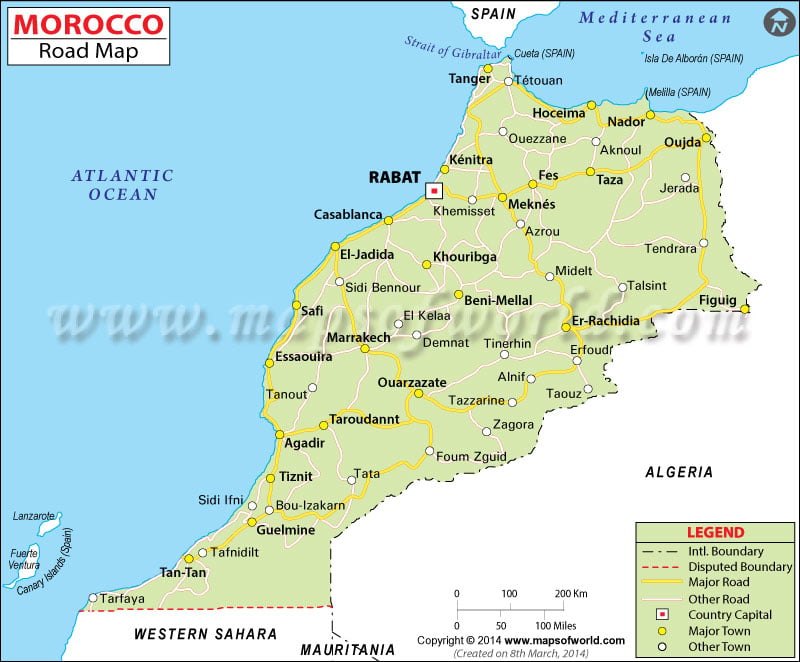
Map Credit: © Maps of the World (mapsofworld.com)
Click on map to enlarge it in a lightbox window.
With over 33 million people, the Kingdom of MOROCCO (Arabic: المغرب; Berber: see image below) is a North African country bordering the Mediterranean Sea. Morocco shares a border with only one country, Algeria, which is located east. A territory currently belonging to Morocco, Western Sahara is located to the south. Morocco is also east of the Canary Islands (link to Canary Islands post) — which belong to Spain — and is south of the Strait of Gibraltar which separates Morocco from Spain and Gibraltar. Like Lesotho and Swaziland, Morocco is one of only three monarchical kingdoms in Africa.
 |
| Berber version of Morocco's name |
● ● ● ● ● People and Places ● ● ● ● ● The ethnicities of Moroccan people are predominantly Arabic and Berber. Arabic is Morocco's official language, with distinct varieties and dialects such as Hassaniyya, Judeo-Moroccan, Moroccan, and standard Arabic. Other languages spoken include French, Ghomara, Senhaja Berber, Spanish (particularly in northern and coastal areas), Tachelhit, Tamazight, Tarifit (Riffian Berber), and Taznatit. At least 90% of the population are Muslims, and some estimates say 99%. In addition to mosques, there are several churches, cathedrals, synagogues, and other places of worship — particularly in Morocco's cities, such as Casablanca and Rabat.
Containing over 1.6 million residents, Morocco's capital is Rabat; this city captivates residents and tourists alike with sites of interest such as the Jardin d’Essais, Medina of Rabat market, Chellah fortification and necropolis, Kasbah of the Udayas, and Old Town district. Several of these attractions are components of UNESCO's Rabat World Heritage Site. Made famous around the world thanks in part to the namesake 1940s film, Casablanca boasts a population greater than 3.1 million and features sites of interest such as the Hassan II Mosque, Old Medina markets, Quartier Habous markets and stores, L'église du Sacré-Coeur cathedral, and an Art Deco-style Cinema Rialto theater. Listed in higher-to-lower population order, other Moroccan cities include Fez, Marrakech, Agadir, Tangier, Meknès, Oujda, Kenitra (Qnitra), and Tétouan. Moroccans use the Moroccan Dirham as their currency, and its ISO 4217 currency code is MAD.
● ● ● ● ● Land Features ● ● ● ● ● Along with Algeria and Tunisia, Morocco is home to the Atlas Mountains, a range stretching about 2,000 kilometers and 1,200 miles parallel to the Mediterranean Sea. Mount Toubkal is the highest mountain in the mountain range, North Africa, and Morocco. It stands 13,671 feet and 4,167 meters tall in elevation above sea level. The Sahara Desert is found in Morocco's southern and southeastern regions and southward into Western Sahara. Moroccan rivers and intermittent streams (wadis) include Oued Drâa in the south, Oued Guir in the east, Oued Moulouya in the northeast, Oued Sebou in the north, and Oued Sous in the south-center area.

Click here to enlarge the map in a new window. This map is available in a wall-poster size courtesy of Eric Olason at Maps.com.
 LIBYA (ليبيا) is an oil-producing country in Northern Africa and located south of the Mediterranean Sea. There are 6 bordering countries: Algeria, Chad, Egypt, Niger, Sudan, and Tunisia. The capital is Tripoli, known as Ṭarābulus in the Arabic language. Other cities in Libya include Benghazi, Darnah, Misratah, Sabratah, and Tobruk. Most of Libya's cities are found along the Mediterranean coastline. Libya's historic regions and provinces are Tripolitania in the northwest, Cyrenaica in the east and southeast, and Fezzan in the southwest. Sirtica is another historic region in between Cyrenaica and Tripolitania. It is also a major oil-producing center.
The Sahara desert extends across central and southern Libya. From north to south, the Libyan Plateau, the Great Sand Sea and Libyan Desert all straddle the border between eastern Libya and western Egypt. North of north-central Libya lies the Mediterranean Sea's Gulf of Sidra. Libyans use the Libyan Dinar as their currency, and the ISO 4217 currency code is LYD.

 Known as مِصر (Miṣr) in the Arabic language, EGYPT is a well-known, predominantly Muslim country located in North Africa. Egypt borders the Mediterranean Sea along its northern coast, and of course this country is known for its ancient history and structural wonders. The pyramids of Egypt are certainly remarkable architectural feats, and the methods in which ancient Egyptians built them were revolutionary and more efficient than ever before. There are 3 bordering countries: Israel located to the east and northeast, Libya to the west, and Sudan to the south. The capital is Cairo, with more than 10 million residents and growing. The currency is the Egyptian Pound, and its ISO 4217 currency code is EGP.

● ● ● ● ● People and Places ● ● ● ● ● Being the tenth largest country in the world, it is no surprise that there are over 37.5 million citizens in Algeria. The capital and largest city is Algiers, also called Alger. There are over 2 million residents in Algiers with plenty of surrounding cities, including 'Aïn Beniau, Bejaïa, Blida, Bordj el Kiffan, Chlef, Larba, and Médéa. Other cities throughout the country include Constantine, El Oued, Oran, Sétif, and Tamanrasset. The official language is Arabic, and the Berber language Tamazight became a national language in 2002. Islam is the country's official religion. Non-nomadic and nomadic Berber people speak several languages. For example, nomadic Taureg Berbers in southern Algeria speak Taureg. Algerians use the Algerian Dinar as their currency, and its ISO 4217 currency code is DZD. As the post link below further explains with a large map, Algeria is administratively divided up into almost 50 provinces (wilayas).
Information and Map of Algeria's Provinces (link opens in new tab or window)
● ● ● ● ● Land Features ● ● ● ● ● Algeria borders the Mediterranean Sea, being south of it. Therefore, the country has seen multiple European influences over thousands of years, being colonized by France in the 1800s up until the 1960s. With a land area of almost 920,000 square miles (2,383,000 sq. kilometers), Algeria is mainly known for the large Sahara desert stretching across much of southern Algeria. However, there are other desert and non-desert features worth mentioning. The picturesque sand dunes of the Grand Erg Occidental (west) and Grand Erg Oriental (east) erg regions in central Algeria are contrasted with rocky surfaces of Hamada du Drâa in the southwest (barely south of Morocco) and Hamada du Tinrhert in the southeast (south of Grand Erg Oriental). Tassilli-n-Ajjer and Tassili Oua-n Ahaggar are plateau regions in southeast Algeria.
The Atlas mountain range spans horizontally across northern Algeria and extends into much of Morocco and northern Tunisia. The smaller Atlas Saharien range is south of the main Atlas mountain range, and the Hauts Plateaux (High Plains) steppe-like region is in the middle of the two. The Ahaggar (Hoggar) mountain range of southeast Algeria lies in Tamanghasset, the country's largest province (wilaya). Algeria's largest mountain, Tahat, is located in the Ahaggar range. This peak stands over 9,570 feet (about 2,920 meters) tall. Chott Melrhir and Chott Merouane are salt pans, intermittent lakes, and wetland areas in northeastern Algeria. A depression lies east of those chotts, near the Tunisian border.
Blog Content
● The author of this GeoFact of the Day Blog creates and curates original, authentic content and posts information based on established facts. Blog posts are not generated by artificial intelligence (AI) but published by the author.
● Content and image graphics from other sources are properly credited. Many geography facts are well-established and therefore do not belong to any one source, but occasionally a fact requires attribution/credit if it is unique and hard-to-find — for example, facts found from specific cultural, anthropological, geological, and scientific (etc.) research.
● I do not copy and paste from other websites. Therefore, all posts are original but may sometimes include information, links, and/or images from credited external sources. To use a GeoFact of the Day Blog image for your website or project, write a comment below a post — then I may approve your request.
● Feel free to offer comments, suggestions, and compliments on any post or page! You can be anonymous. Spam comments with non-relevant links will be deleted.
● Thanks for your loyal readership on the educational and reliable GeoFact of the Day Blog, in existence since 2008!


