
Informative geography facts about our wonderful planet, detailed and easy-to-read maps, and various topics about each country! I am pleased to update my blog as a passion project and do not generate content with AI.

Showing posts with label Indiana. Show all posts
Showing posts with label Indiana. Show all posts
Friday, September 5, 2025
Indiana West Nile Virus 2025 Update
The Indiana Department of Health has a new Mosquito-Borne Illness Dashboard (↗) featuring two statewide maps. These maps show counties with mosquitoes and people infected by the West Nile Virus. The right-side map shows human infections. So far in 2025 as of September 5th, there were 10 people infected in the counties of Bartholomew (1), Hamilton (1), Madison (1), Marion (4), Vanderburgh (6), and Wells (1).
Almost all counties have at least one infected mosquito (based on test results) except the following ones mostly in Southern Indiana: Crawford, Dubois, Jefferson, Lawrence, Martin, Orange, Owen, Perry, Pike, Vermillion, and Washington. Union County has not tested for mosquitoes so far this year, or the test results have not been updated on the map. At first, the left map shows Hamilton County (Carmel, Fishers, Noblesville, Westfield, etc.) with the most mosquito infections at 128. However, the Collection tab and corresponding mosquito collection map shows this county tested a tremendous amount of mosquitoes (28,112) for the virus resulting in the inflated infection number. By comparison, Marion County (Indianapolis area) has 48 mosquito infections based on 9,847 tests.

Wednesday, January 13, 2021
2020 Presidential Election Results — Georgia to Indiana
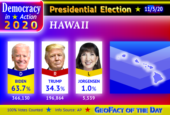
Here are the 2020 Presidential Results from the states of Georgia to Indiana in alphabetical order:



Wednesday, January 8, 2020
Indiana Counties Named After People

As you can see by the "sea of blue" stretching across the map above, a vast majority of counties (68) in Indiana, USA are named after honorable people who were either born as an American or British citizen. Adams, Harrison, Jackson, Jefferson, Madison, Monroe, and Washington counties are named in honor of U.S. Presidents. Four counties are named in honor of Native American groups/nations or individuals: Delaware (Delaware nation), Elkhart County (possibly Chief Elkhart), Miami County (Miami nation), and Wells County (William Wells, raised by Miami natives).
Three counties are named for war heroes who were born within the geographic territory (Holy Roman Empire, Prussia, etc.) that is now considered present-day GERMANY: DeKalb County (Johann de Kalb, a baron), Jasper County (William Jasper), and Steuben County (Baron von Steuben). Sergeant William Jasper's birthplace is disputed, but South Carolina Educational Television's Knowitall.org website (↗) theorizes that he likely emigrated from Germany to Philadelphia in 1767 (at about age 17) and later moved to the South, eventually rescuing the South Carolinian flag at Fort Moultrie. The United States Mint's 2016 America the Beautiful quarter for South Carolina (↗) depicts an active and heroic scene at Fort Moultrie; on this coin, Jasper is "returning the regimental flag to the ramparts while under attack from a British ship."
Tadeusz Kosciuszko (Kosciusko) and Kazimierz Pulaski were born in present-day POLAND. Toussaint Dubois was born near present-day Montreal, CANADA, Gilbert du Motier (Marquis de la Fayette) was born in FRANCE, Richard Montgomery was born in the Kingdom of IRELAND, and Francis Vigo was born in present-day ITALY. Only 11 counties are not named after war heroes, patriots, leaders, Native American groups, or Native American individuals: LaGrange, Lake, LaPorte, Ohio, Orange, Saint Joseph, Switzerland, Tippecanoe, Union, Vermillion, and Wabash counties.
Bonus Fact: Alexander Hamilton — who is honored in the name of Hamilton County in Indiana and seven other states — was born in the city of Charleston, British Leeward Islands. Charleston sits on Nevis island which is presently part of the country SAINT KITTS AND NEVIS.
Sunday, October 6, 2019
Jasper and Newton County Combos
Throughout the UNITED STATES, there are five combinations in which a Jasper County is directly bordering a Newton County. These combinations occur in the states of Georgia, Indiana, Mississippi, Missouri, and Texas and are depicted in the maps below. Sergeants John Newton and William Jasper were soldiers who fought valiantly in the American Revolutionary War, so it is fitting that Jasper and Newton counties would be situated right next to each other. Other instances of Jasper County are located in Illinois, Iowa, and South Carolina; another instance of Newton County is located in Arkansas.
Map of Jasper and Newton counties in Georgia

Map of Jasper and Newton counties in Indiana

Map of Jasper and Newton counties in Mississippi

Map of Jasper and Newton counties in Missouri

Map of Jasper and Newton counties in Texas

Thursday, June 27, 2019
Recap of the June 23rd South Bend Tornadoes
Warning: tornado pictures are shown in this post!

A city of over 100,000 residents in north-central Indiana, South Bend was the unlucky yet lucky (I'll explain the lucky part soon) site for two peculiar tornadoes that seemingly came out of nowhere. Even WNDU Channel 16's renowned Chief Meteorologist, Mike Hoffman, was quite surprised by the tornadoes' sudden and rare formation. The image of the first tornado was captured from a Facebook video by Tricia Sloma, a popular — and apparently brave — news anchor for WNDU's morning news. This EF 0 tornado touched down near Roosevelt Road after 8:30 PM Eastern Time. Tricia's photo illustrates how relatively minuscule this tornado was; its widest path on the ground was 10 yards, highest winds were 65 to 70 miles per hour, and the tornado path was a half mile (0.5 miles) in length. Barn doors and tree branches were damaged.
First Tornado

Second Tornado

In comparison to the first tornado, the second tornado (EF 2 strength) was a mighty beast aiming to devour the south side of South Bend! Branches from large trees fell down, the Irish Hills apartment complex experienced some aesthetic damage, electricity went out for hundreds of homes and businesses, and a residential screened building and the Growing Kids daycare facility were partially destroyed. Even though the CVS Pharmacy is across the street from Growing Kids, its facility was virtually unspared — with a possible power outage being a temporary inconvenience. There is video footage available of tornadic winds swirling across a portion of U.S. Highway 20! Fortunately, drivers on the two-lane restricted highway (under construction) knew the tornado was coming, giving room for the tornado to cross the highway without incident.
All in all, South Bend was lucky on June 23rd. Despite a rather massive tornado hovering over the south side, miraculously no one was killed or seriously hurt. This tornado developed at 8:38 PM Eastern Time, ran for about 2 miles and up to 200 yards wide, and brought winds of 115 to 125 mph. Growing Kids will certainly have to rebuild to get their service up and running, but thank goodness the tornado occurred on a Sunday — when no kids or employees were present at that site. Even the custodian/janitor was not there! While this tornado was merciful, it was a strange one: its cloud height was less than 18,000 feet, and there was no lightning or thunder associated with it! The footage of the second tornado above and below is credited to Ashlee Sassaman and Tomi Vicen, respectively. More information about this tornadic event is provided by the National Weather Service of Northern Indiana (↗).

Sunday, June 23, 2019
Indiana's 1st Report of West Nile Virus in 2019
Several days ago, health officials in Elkhart County, Indiana, USA reported the first lab-tested mosquitoes infected with the West Nile Virus in Indiana this year. The West Nile Virus can be transmitted to people, so precautions such as applying DEET insect repellent and dumping water from various outdoor items (watering cans, old tires, etc.) are recommended. Hoosiers *use to be able to* stay up-to-date on the geographic distribution of the West Nile Virus by visiting the Indiana State Dept. of Health's interactive Arboviral Encephalitides map. That website — https://gis.in.gov/apps/ISDH/Arbo/ — is now defunct. Similar websites are available for residents of some other states as well.
Thursday, December 6, 2018
2018 Indiana Senate Election Results and Map

Supporters of the Democratic Party celebrated its achievement of "taking over" the UNITED STATES House of Representatives in 2019, seating 234 Democrat representatives versus 199 Republican representatives. However, the U.S. Senate election outcome was a different story — and Indiana was one culprit. The hotly contested competition between incumbent Senator Joe Donnelly (D, Granger) and businessperson and former state legislator Mike Braun (R, Jasper) resulted in the crowning of Mike Braun as Indiana's next Senator to serve alongside Todd Young (R, Bloomington). Braun earned 51% of the total votes, while Donnelly earned 45.1% of the total votes. Libertarian candidate, business consultant, and author Lucy Brenton (L, Fishers) earned 3.9% of the votes. Donnelly received a majority of votes in Delaware, Lake, LaPorte, Marion, Monroe, Porter, Saint Joseph, Tippecanoe, and Vigo counties. Based on percentages, Braun received the most support in Daviess, Dearborn, Franklin, Kosciusko, Ripley, and Wells counties.
The General Election results used to compile this post were provided by the Indiana Secretary of State's Election Division (↗). Wish to see a recap post regarding another state or local election? Let me know with a comment below!

Monday, October 29, 2018
30 Hoosiers Infected by the West Nile Virus
As the mosquito-swatting season continues to wind down in Indiana and elsewhere in the UNITED STATES, Indiana State Department of Health's interactive Arboviral Disease map reveals the number of people infected by the West Nile Virus: 30. This is not too far away from last year's 26 human infections, but compare this to the 9 infections seen in 2014. Throughout 2018, people were infected in these counties: Allen (5), Delaware (3), Elkhart (2), Grant (1), Hamilton (4), Hendricks (1), Huntington (1), Lake (4), LaPorte (1), Marion (2), Porter (1), Vanderburgh (4), and White (1).
688 mosquitoes in 87 out of 92 Hoosier counties tested WNV-positive in lab tests throughout the year. 18 horses were infected as well, especially in Adams County (10 cases) but also in Harrison (1), Jay (3), Lake (1), Noble (1), Tippecanoe (1), and Whitley (1). For the first time in recent years, Eastern Equine Encephalomyelitis (EEE) infected horses: one each in Kosciusko and Whitley counties. For more information about the West Nile Virus situation in Indiana this year and in the past, access the All About Indiana webpage (↗) on GeoFact of the Day.
Monday, July 16, 2018
9 Counties have West Nile Virus Mosquitoes — Indiana 2018
As of Monday, July 16th, 2018, nine counties in Indiana tested mosquitoes and have confirmed West Nile Virus in some of those mosquitoes. The nine counties are Allen (2 batches with WNV), Bartholomew (1), Carroll (1), Elkhart (2), Hamilton (1), Marion (6), Monroe (1), Putnam (1), and Tippecanoe (2). Please consider precautions to prevent being bit by mosquitoes, since the West Nile Virus can cause distressful side effects — especially in children and elderly people. Wear lightweight but long clothing to cover bare skin, spray repellent containing DEET on yourself when enjoying the outdoors (especially at dusk), and empty water that collected outside in containers, etc. so that more mosquitoes cannot be born. Stay up to date on the Hoosier West Nile Virus situation with the Indiana Department of Health's Interactive Infection Map. This website has individual maps for mosquito infections, bird infections, equine/horse cases, and if people contract the non-contagious virus.
Sunday, September 17, 2017
American Towns: Plevna
Five unincorporated villages in the UNITED STATES are named after a city thousands of miles away in Europe: Plevna (Pleven), home to about 100,000 people in northern BULGARIA. Residents chose to name their towns after Plevna because it was the site of the Siege of Plevna, a consequential and globally known battle of the Turko-Russian War in 1877. The five Plevna towns in the United States are found in the states of Alabama, Indiana, Kansas, Missouri, and Montana. Approximate population figures for the towns in Kansas, Missouri, and Montana are listed on the GeoNames (geonames.org) website. The Alabama and Indiana versions might only have about a dozen residents each!
Plevna, Alabama (Madison County)

Plevna, Indiana (Howard County)

Plevna, Kansas (Reno County) — population 97

Plevna, Missouri (Knox County) — population 21

Plevna, Montana (Fallon County) — population 183

Monday, June 12, 2017
2 People Contract West Nile Virus — Indiana 2017
Two people from different parts of the state recently contracted the West Nile Virus on Friday, June 9th. These infections were discovered at hospitals in Hamilton and Lake counties. So far, no mosquitoes have been confirmed to have WNV in lab-test results in these counties. Therefore, these individuals may have been infected in other areas where WNV-infected mosquitoes are present for this year, or locally despite the lack of confirmed mosquito infections in Hamilton and Lake counties. To track WNV infections among Hoosier mosquitoes and people throughout the rest of spring, summer, and fall seasons, access the Indiana St. Department of Health's Arboviral Disease Map. For a nationwide outlook on arboviral viruses and diseases such as Chikungunya, Dengue, Saint Louis Encephalitis, and West Nile Virus, access the CDC/USGS interactive disease map (diseasemaps.usgs.gov/mapviewer link now defunct).
Friday, June 9, 2017
First Mosquitoes to Contract West Nile Virus — Indiana 2017
It's another season of mosquitoes "out for blood" in the United States and elsewhere, and health officials are testing for West Nile Virus in those bloodsuckers. In Indiana, the first lab-tested batch of mosquitoes with the WNV have been confirmed in a neighboring county southwest of Indianapolis — Morgan County, to be exact. Therefore, residents of rural areas and communities including Martinsville, Mooresville, Bethany, Brooklyn, Centerton, Chetwynd, Cope, Eminence, Exchange, Five Points, Landersdale, Little Point, Mahalasville, Monrovia, Morgantown, Paragon, Wakeland, Whitaker, and Wilbur should be particularly wary of mosquitoes.
The good news: only a very small percentage of local mosquitoes (likely less than 1%) carry the West Nile Virus, and many WNV-infected people do not experience fever or other symptoms. Regardless, it's still a good idea to take precautions to prevent being bit — especially with the use of insect repellent (should include DEET) and protective clothing to cover skin. To track WNV infections among Hoosier mosquitoes and people throughout the rest of spring, summer, and fall seasons, access the Indiana St. Department of Health's Arboviral Disease Map.
Thursday, March 16, 2017
2016 Indiana Education Superintendent Election
This is the last 2016 Election-related post on GeoFact of the Day. Below is a GeoFact of the Day Blog map showing the total number of votes received by Democratic candidate Glenda Ritz and Republican candidate Jennifer McCormick during the November 8th, 2016 election in Indiana. According to the Indiana Secretary of State's Election website (↗), voters in 82 counties elected Jennifer McCormick to be Indiana public schools' Superintendent of Public Instruction, while voters in 10 counties favored Glenda Ritz. Voters in Lake, LaPorte, Marion, Monroe, Perry, Porter, Saint Joseph, Tippecanoe, Vermillion, and Vigo counties preferred Ritz to win. Percentage-wise, McCormick won with 53.4% of the vote, while Gitz earned 46.6% of the vote. Access this GeoFact of the Day post (↗) for results in 2012. In that election, Ritz defeated Tony Bennett — the former superintendent, not the famous nonagenarian singer!

Monday, March 13, 2017
2016 Indiana Governor Election
Below is a GeoFact of the Day Blog map showing the total number of votes received by Democratic candidate John Gregg and Eric Holcomb — the Republican candidate and current Governor of Indiana — during the November 8th, 2016 election. According to the Indiana Secretary of State's Election website (↗), voters in 79 counties elected Republican Eric Holcomb (shaded in rose and cherry red colors) as governor compared to 13 counties favoring Democrat John Gregg (shaded in periwinkle and blue colors). The counties with light blue (periwinkle) and light red (rose) colors indicate that the favored candidate had a smaller margin of victory, compared to the more-dominant voting percentages (%s) in darker blue and darker red counties. The five light-blue Democratic counties are Delaware, Perry, Saint Joseph, Tippecanoe, and Vermillion, and the eight darker-blue counties are Knox, Lake, LaPorte, Marion, Monroe, Porter, Sullivan, and Vigo. The five light-red Republican counties are Greene, Madison, Pike, Starke, and Vanderburgh.

Monday, January 23, 2017
Indiana Towns Named after Capitals and Countries
Corresponding to the All About Indiana page's last section, this interactive map depicts the Indiana communities that are named after countries and national capitals around the world. All of these towns are relatively small in population, especially New Amsterdam in Harrison County. New Amsterdam only has 27 residents according to latest population estimates, but this is a vast improvement from 2000 to 2009; there was only one person inhabiting New Amsterdam at that time! To maximize this map in a new tab or window, simply click the frame rectangle icon in the top right (next to Share button). I hope you enjoy this map...what are some other topics you would love to see in an interactive map? Feel free to sound off in the comments section!
Monday, January 2, 2017
2016 Voting Results for Jill Stein in Indiana
First of all, Happy New Year 2017! May it be a healthy and happy one for you. Further below is a GeoFact of the Day Blog map showing the number of votes Jill Stein (jill2016.com) received in each Indiana county, according to data from the Indiana Secretary of State's Election website and several county websites. This election occurred on Tuesday, November 8th, 2016, and Jill Stein was the Green Party presidential candidate in the election. Despite not being listed on the ballot, she received a total of 7,841 votes in the Hoosier State as a write-in candidate — access this post for complete election results for each US state. In Indiana, Stein received the most votes in the following counties (highest to lower): Lake, Marion, Allen, Monroe, Saint Joseph, Porter, Tippecanoe, Hamilton, and Delaware. In the counties with diagonal lines on the map — Clark, Crawford, Fayette, Fulton, Martin, Newton, Noble, Orange, Pike, Posey, Randolph, Rush, Starke, Sullivan, Tipton, and Warrick counties — either Stein did not receive any votes or counties did not separate write-in votes by candidate. For example, 642 total write-in votes were recorded without separation in Clark County. Neighboring Floyd County voters gave 157 write-in votes to Stein. Since Clark County's population is larger than Floyd's by almost 35,000, it is reasonable to assume that Jill Stein earned more than 157 votes in Clark County.

Monday, November 14, 2016
2016 US Presidential Election Results
ELECTORAL VOTES
306 for Donald Trump, 232 for Hillary ClintonPOPULAR VOTES
62,984,825 for Donald Trump, 65,853,516 for Hillary ClintonVOTING %
46.4% for Donald Trump, 48.5% for Hillary ClintonStat Credits: CNN Election Center @ cnn.com/election
(CNN webpage will likely be archived to cnn.com/election/2016 in the future)
💫 What an election that was! 🌟 I recently completed images showing all the U.S. Presidential Election results from every state (and District of Columbia, also known as Washington, D.C.) in the UNITED STATES OF AMERICA. The main takeaway from this election is that Donald Trump won based on the Electoral College, receiving 306 electoral votes compared to Hillary Clinton's 232. However, Clinton received about


Subscribe to:
Posts (Atom)
Thanks for Visiting from Anywhere in the World!