Search for Posts, Maps, and Topics
I searched the interwebs and happened to find a wonderful resource that would be great for coloring fun all while getting a geography education. A digital image collection provided by the Florida Center for Instructional Technology (FCIT) — part of the College of Education at the University of South Florida — ClipArt ETC houses over 200 black and white world flags (↗) that could be used as printable coloring pages. If you know about all the world's countries, you might notice some countries' flags are missing — including AFGHANISTAN, HAITI, KAZAKHSTAN, LIECHTENSTEIN, LUXEMBOURG*, MALTA, and ZAMBIA. Nevertheless, lots of coloring fun can be had since the website's images are easy to copy/paste into a document and print. For educational, classroom, and non-profit uses, ClipArt ETC grants you "permission to use a maximum of fifty (50) clipart items in any non-commercial, educational project (report, presentation, display, website, etc.)" although there are some reasonable restrictions. More information about the free (and commercial) licensure options can be found on the ClipArt ETC website (↗). If you are a teacher, you could let your students choose a flag to color and instruct them to create a poster or PowerPoint presentation involving the flag's country. Enjoy, and kudos to FCIT for a wonderful website!
* The NETHERLANDS' flag can be used as a substitute due to three-stripe similarity.


1) The Congo Pedicle is a foot-like panhandle region in the southeastern corner of the DEMOCRATIC REPUBLIC OF THE CONGO and situated near ZAMBIA. The pedicle area features a national park known as Demalisques de Leshwe, possibly named after the genus (damaliscus) of which animal?
A — sloth
B — aardvark
C — antelope
D — penguin
2) True or false: There is an island named Komodo in INDONESIA.
3) The third highest mountain the world is Kangchenjunga, a Himalayan peak standing over 8,500 meters and 28,000 feet tall. Kangchenjunga is situated on the border between INDIA and what mountainous country flying a double pennant shaped flag?
A — ARGENTINA
B — BANGLADESH
C — SWITZERLAND
D — NEPAL
ANSWERS
Question 1:
C . . . . . antelope
Question 2:
True . . . . . it is home to the world-renown Komodo dragon!
Question 3:
D . . . . . Nepal
1) Fill in the blank: along the mighty Zambezi River, _________ of ZAMBIA and ZIMBABWE is the world’s largest artificial lake by volume as of the year 2023.
A — Lake Baikal
B — Lake Kariba
C — Lake Tanganyika
2) True or false: The community of Nahwa in the UNITED ARAB EMIRATES is completely surrounded by Madhā in OMAN. Also, the doughnut-shaped territory of Madhā is surrounded by additional land of the United Arab Emirates.
3) Fill in the blank: standing at over 8,281 feet (2,524 meters) in elevation, the highest mountain of SRI LANKA is _________.
A — Dealul Balanesti
B — Pidurutalagala
C — Hombori Tondo
ANSWERS
Question 1:
B . . . . . Lake Kariba
Question 2:
True . . . . . Nahwa is rare phenomenon known as a counter-exclave — in which an exclave (Nahwa) is surrounded by another exclave (Madhā). Nahwa is the “egg yolk” to Madhā’s “egg white”!
Question 3:
B . . . . . Pidurutalagala
● Copper
● David Livingstone
● Growing tourism
● Peaceful sunsets
● The Victoria Falls
● The Zambezi River
● Troubled political history but a current multiparty democracy
Most items were listed in The Africa Book; the MLA citation is below. What are other "trademarks" of this African country? Feel free to share your thoughts with a comment!
Phillips et al. The Africa Book: A Journey through Every
Country in the Continent. Lonely Planet, 2007.
— #AfricaWeek —
According to National Geographic MapMaker (mapmaker.nationalgeographic.org) and MIT's Observatory of Economic Complexity (atlas.media.mit.edu), the following items are major exports of ZAMBIA: animal hides, barley, beverages, bran, breakfast cereal, broadcasting equipment, cassava, cereal meal and pellets, chemicals, clothing and textiles, coal, cobalt, coffee, confectionery sugar, construction vehicles and cranes, copper, copper products (including bars and wire), corn (maize), cut flowers, excavation machinery, fertilizer, frozen vegetables, gemstones (especially diamonds and emeralds), gold, hydroelectricity to neighboring countries, insulated wire, interchangeable tool parts, iron products, lead, legumes, liquid pumps, magnesium carbonate, military ammunition and weapons, molasses, mollusks, olive and palm oil, packaged food, paper containers, peanuts, postage stamps, poultry meat, quicklime, raw and refined copper, rice, silver, sorghum, soybeans and soybean meal, sugarcane, sulphur (sulfur), sunflower seeds, tobacco, unmentioned edible preparations, uranium (small amounts), vegetable residues, wheat flour, wood, yeast, and zinc.
According to February 2017 statistics from the International Monetary Fund (data.imf.org), countries and territories buying and importing most of those exports include Switzerland (top importer), China, the United Arab Emirates, Democratic Republic of the Congo, South Africa, Zimbabwe, India, Singapore, the United Kingdom, Hong Kong, Malawi, Luxembourg, Tanzania, Japan, Kenya, Namibia, Botswana, Mozambique, Germany, Rwanda, Burundi, South Korea, Sweden, the Netherlands, Belgium, Mauritius, Algeria, Swaziland, the United States, Uganda, Angola, Australia, Hungary, Ireland, and Madagascar.
Another new map of another African country is now posted on GeoFact of the Day. Located approximately 4,000 kilometers southeast of BURKINA FASO, the Republic of ZAMBIA is the topic of a comprehensively updated post, which now includes a map identifying neighboring countries as well as featuring major communities, lakes, rivers, and waterfalls. See the map on my Zambia post (↗)!

 Post #5 — Country Quizzes Week
During the week of Monday, February 27th to Sunday, March 5th, GeoFact of the Day is hosting a Country Quiz Week. Every day or every other day, there will be a new quiz on a particular country around the world. Want to see a post about a favorite country? Feel free to share your suggestion by posting a comment! See if you can answer these questions pertaining to ZAMBIA without the help of literary resources and the Internet. Answers are provided at the end — Good Luck!
1) There are approximately 46 main languages currently spoken in Zambia, according to Ethnologue.com (↗). How many Bantu-speaking ethnic groups are represented in Zambia's population?
A — Over 150
B — Over 25
C — Over 70
D — Over 55
2) Which of the following is considered a dying language, meaning there might not be any communicators of that language in the near future? (Credit: Ethnologue.com)
A — Yauma
B — Chichewa
C — Bemba
3) About 250 kilometers south of Lake Tanganyika, the Bangweulu Swamp is found in which part of Zambia?
A — southern
B — western
C — eastern
D — northern
4) What country does not share a border with Zambia?
A — ANGOLA
B — BURUNDI
C — MALAWI
D — MOZAMBIQUE
5) All these cities are located in Zambia except ____________________.
A — Ndola
B — Lubango
C — Mansa
D — Lusaka
ANSWERS
Question 1:
C . . . . . Over 70
Question 2:
A . . . . . Yauma
Question 3:
D . . . . . northern
Question 4:
B . . . . . Burundi
Question 5:
B . . . . . Lubango, which is located in Angola
So, how did you do? Thanks for taking this quiz! Map image is credited to National Geographic's Mapmaker Interactive (↗)
The IUCN Red List of Threatened Species™ for ZAMBIA in Southern Africa lists 12 critically endangered species and 25 endangered species. These are Zambia's critically endangered species: the African Slender-Snouted Crocodile, Banded Neolebias fish, Bellamya mweruensis freshwater snail, Bellamya pagodiformis freshwater snail, Eragrostis muerensis, Hooded Vulture bird, Hook-Lipped Rhinoceros, Mozzie fish, Rueppell's Griffon bird, White-Backed Vulture, White-Headed Vulture, and White-Winged Crake bird. Endangered species include Ansell's Shrew, Cape Griffon, Cape Hunting Dog, Forktail Lates fish, Malagasy Pond Heron, Southern Crowned Crane, Steppe Eagle, and Tanganyika Lates fish. Zambia-named species: Zambia Slim damselfly and Zambian Mole Rat. There are some scary photos of Zambian Mole Rats' teeth online — yikes!
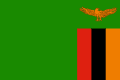
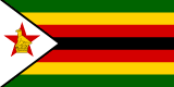
As the GeoFact of the Day Blog's Z Countries post reveals, there are two countries with names starting with the letter Z. ZAIRE was another Z country until 1997, the year it was renamed Democratic Republic of the Congo. A much smaller and short-lived country than Zaire, ZANZIBAR lasted less than one year (in 1964) before merging with Tanganyika to create Tanzania. Zambia and Zimbabwe flag images below come from Flagpedia.net; Zaire and Zanzibar flag images are derived from Wikipedia images.
ZAMBIA
 ZIMBABWE
 Flags of Former Z Countries
ZAIRE
ZANZIBAR
Flags of Former Z Countries
ZAIRE
ZANZIBAR
There are sixteen countries with Z in their names. Two countries start with the letter Z: Zambia and Zimbabwe. Other countries with the letter Z in their names are Azerbaijan, Belize, Bosnia and Herzegovina, Brazil, Czech Republic, Kazakhstan, Kyrgyzstan, Mozambique, New Zealand, Swaziland, Switzerland, Tanzania, Uzbekistan, and Venezuela. Zaire was a former Z country, but that became the Democratic Republic of the Congo.
 The A to Z categories are based on the English language and inadvertently might not include all native country names.
Neighbors in both the alphabet and geography, ZAMBIA and ZIMBABWE are located in Southern Africa. Both countries share the famous Victoria Falls, which lie on their borders along the Zambezi River. The magnificent waterfalls are located south of Livingstone, Zambia and east of Victoria Falls, Zimbabwe.
ZHŌNGGUÓ (China) could be considered as an additional Z country. This country is also featured in the C Countries post.
GeoFact of the Day Blog Post Links
Zambia — Zimbabwe — Zhōngguó
Out of all the countries in Southern Africa, the Kingdom of LESOTHO, MALAWI, and NAMIBIA have the highest percentage of Christians. Anywhere from 80 to 90% of the people in these countries are Christians, while many of the rest believe in indigenous beliefs. There is a small population of believers in other religions. Other Southern African countries with high percentages of Christians include ANGOLA, SOUTH AFRICA, SWAZILAND, and ZAMBIA. Christian missionaries from around the world played a pivotal role in introducing Christianity to Sub-Saharan Africa.
I bet you knew about Victoria Falls, a spectacular destination along the Zambezi River on the border of ZAMBIA and Zimbabwe. Did you also know that Zambia, situated in South-Central Africa, boasts quite a lot of waterfalls? The Chavuma Falls are located near Angola in northwest Zambia, and you would find the Ngonye Falls 200 miles south. Travel even more south (before reaching the Caprivi Strip of Namibia), and you find the Kasanga Falls. All three straddle the Zambezi River. Falls in northern Zambia include Chisimba Falls (near the city of Kasama, along the Lukulu River), Mambilima (Johnston) Falls, and Mumbotuta Falls. Both of the aforementioned 'M' falls are situated on the Luapula River, which borders the Democratic Republic of the Congo. The Lumangwe Falls is the northernmost waterfall that I have mentioned. It is found along the Kalungwishi River, east of Lusenga National Park, and southeast of Lake Mweru.

● ● ● ● ● People and Places ● ● ● ● ● Based on the GeoFact of the Day Blog’s 2016 estimate, Zambia’s total population is approximately 12,060,000 and growing. Located in south-central Zambia less than 100 kilometers away from Zimbabwe, the capital and most-populated city is Lusaka with about 982,000 residents. Other Zambian cities include Chingola (170,000), Choma, Kabwe (population: 168,000), Kasama, Kitwe (247,000), Livingstone, Lundazi, Mbala, Ndola (377,000), Serenje, and Zambezi.
Zambians culturally identify themselves in over 70 ethnic groups of people — including the Bemba, Kaonda, Lozi, Ngoni, and Tonga ethnicities. While English is used as an official language by some citizens and for government purposes, Zambians speak about 70 native ethnic languages, many of which correspond to the namesake ethnic tribe. Major native languages include Bemba, Kaonda, Lozi, Lunda, Luvale, Nyanja, and Tonga. At least one-half of religious citizens are Christian, while one-fourth of people are Hindu and Muslim adherents.
Protected and publically accessible national parks are scattered throughout the country. Parks in the northeastern “panhandle” include Isangano NP, Kasanka NP, Lavushi-Manda NP, Luangwa NP (split into north and south sections), Lukusuzi NP, Lusenga NP, Mweru-Wantipa NP, and Nsumbu NP. Other national parks include Blue Lagoon and Lochinvar national parks (south-central Zambia), the large Kafue NP (west-central Zambia), Liuwa Plain NP (west), Lower Zambezi NP (southeast), Sioma Ngwezi NP (southwest), and West Lunga NP (northwest).
● ● ● ● ● Land Features ● ● ● ● ● Aquatic and physical features in northern and eastern Zambia include the Bangweulu Swamp, Chisimba Falls, Johnston Falls, Lake Bangweulu with Mbabala island, Lake Mweru with Kilwa island, Muchinga Mountains, and Sunzu mountain (elevation: 2,067 meters). Zambians and tourists alike enjoy dramatic cliff views of the Wonder Gorge, located in east-central Zambia along the Lusemfwa River. About 150 kilometers west lies the Lukanga Swamp, home to various endangered species and undoubtedly many pesky mosquitoes! Kuyamba Hills are northwest of the swamp, while the Mufulwe Hills are northeast of Wonder Gorge.
What is the highest point in Zambia, you might (or might not) ask? Well, the answer is unfortunately not 100% clear. On the border between eastern Zambia and western Malawi, Mwanda Peak (elevation: about 2,150 meters, 7,050 feet) is known as the Zambia border's highest point. Near the town of Mkushi in north-central Zambia, Mount Mumpu (1,950 meters, 6,400 feet) is known as the country's highest free-standing mountain. Interestingly, one of the routes up Mt. Mumpu traverses through one of Southern Africa's largest bat caves. Ultimately, though, the highest point designation likely belongs to Mafinga Central (according to Peakbagger.com and other sources) — boasting an elevation of 2,339 meters and 7,674 feet. Could there be an even higher point in Zambia somewhere? That could be a mystery yearning to be solved!
The ridge-like Zambezi Escarpment protrudes from southern Zambia into northern Zimbabwe. Its location is north of Lake Kariba, which stretches along the southern border with Zimbabwe. West and east of Lake Kariba, the Zambezi River stretches completely along the Zambia-Zimbabwe border. Before reaching southern Zambia, Zambezi begins in eastern Angola (location of its headwaters), then flows southward past the town of Zambezi and eventually reaches the borders of Namibia and then Zimbabwe. Arguably the most popular tourist attraction in Zambia, the Victoria Falls are along the Zambezi river in southwestern Zambia, near Zimbabwe’s western tip (see map). Other waterfalls are highlighted in the GeoFact of the Day Blog’s Waterfalls of Zambia post (↗).
This post was comprehensively updated on August 25th, 2016.
The map of Zambia was added on June 18th, 2017.
Blog Content
● The author of this GeoFact of the Day Blog creates and curates original, authentic content and posts information based on established facts. Blog posts are not generated by artificial intelligence (AI) but published by the author.
● Content and image graphics from other sources are properly credited. Many geography facts are well-established and therefore do not belong to any one source, but occasionally a fact requires attribution/credit if it is unique and hard-to-find — for example, facts found from specific cultural, anthropological, geological, and scientific (etc.) research.
● I do not copy and paste from other websites. Therefore, all posts are original but may sometimes include information, links, and/or images from credited external sources. To use a GeoFact of the Day Blog image for your website or project, write a comment below a post — then I may approve your request.
● Feel free to offer comments, suggestions, and compliments on any post or page! You can be anonymous. Spam comments with non-relevant links will be deleted.
● Thanks for your loyal readership on the educational and reliable GeoFact of the Day Blog, in existence since 2008!


