Search for Posts, Maps, and Topics
In this Quick GeoFact post, some of MALAWI’s towns, cities, and villages are alphabetized in an A to Z list below! Would you want to see a future A to Z Cities post for a particular country? Let me know with a comment or email!
A — Alimenda, Alufasi, and Azyuda
B — Balaka, Balakasi, Biza, Blantyre, and Bwemba
C — Chikwawa, Chileka, Chimombo, Chipeka, Chipwaila, Chisenga, and Chitipa
D — Dedza, Domasi, and Dowa
E — Edingeni, Ekwendeni, and Euthini
F — Feremu, Fodya, and Fombe
G — Golomoti, Gotangota, and Gwalangwa
H — Hale, Hawilani, and Haniniya
I — Ifumbo and Imbwa
J — Jalasi, John Malindeni, Jonathan, and Jombo
K — Kacimphula, Kafukule (Kafukula), Karonga, Kasiya, Kasungu, Katumbi, and Khonjeni
L — Lilongwe (national capital), Liwonde, Luchenza, and Lunzu
M — Mangochi, Mchinji, Monkey Bay, Mponela, Mulanje, Muruma, Mwambo, and Mzuzu
N — Namwera, Nchalo, Ngabu, Nkhotakota, Nsanje, Ntcheu, and Ntchisi
O — Onga
P — Padzua, Pende, and Phalombe
Q — there are none (as far as I know)
R — Rodreck and Rumphi
S — Salabeni, Salima, and Sanjama
T — Tendo, Thekerani, Thyolo, Timbenao, and Topoloni
U — Umi, Utale, and Uzinga
V — Viphya
W — Wachaza, Walker’s Ferry, and Wimbe
X — there are none (as far as I know)
Y — Yonam and Yotham Nyondo
Z — Zalewa, Zamkutu, Zimponje, Zironzo, and Zomba
People all across MALAWI celebrated their country's Independence Day on Monday, July 6th — just like the citizens of Comoros. This holiday comes after Malawi conducted a relatively successful and democratic Presidential Election on June 23rd. This East and Southern African country achieved independence from the United Kingdom in 1964. Happy belated Independence Day!
● Lake Malawi
● Birdlife
● Malawian Chief's chair
● Snorkeling
● Colorful cichlid fish
● HIV/AIDS, unfortunately
Most items were listed in The Africa Book; the MLA citation is below. What are other "trademarks" of this African country? Feel free to share your thoughts with a comment!
Phillips et al. The Africa Book: A Journey through Every
Country in the Continent. Lonely Planet, 2007.
— #AfricaWeek —
According to MIT's Observatory of Economic Complexity (atlas.media.mit.edu), the following items are major exports of MALAWI: animal hides, aquarium fish (especially cichlids), bran, clothing, coal briquettes (blocks), coffee, construction vehicles, corn (maize), cotton, cranes, delivery trucks, dried legumes and other vegetable products, fertilizer, footwear, light fixtures, liquor, lumber and plywood, metal molds, nuts, oilseeds, plastic products, railroad freight cars, rubber, soldering and welding machinery, soybean meal, sugar, tea, and tobacco. According to the International Monetary Fund (data.imf.org), countries and territories buying and importing most of those exports (February 2017 statistics) include Zimbabwe (top importer), Mozambique, South Korea, South Africa, China, the United Kingdom, Belgium, Egypt, Germany, the United States, Denmark, Russia, Kenya, Poland, the United Arab Emirates, Ukraine, Tanzania, India, Czech Republic, the Netherlands, Singapore, Uganda, and Zambia.
The IUCN Red List of Threatened Species™ for MALAWI in Southeastern Africa lists 8 critically endangered species and 36 endangered species. There are fortunately no extinct species listed for Malawi. Critically endangered species are the Allocnemis maccleeryi damselfly, Chapman's Pygymy Chameleon, Hooded Vulture, Hook-lipped Rhinoceros, Mulanje Cypress Tree, Mulanje Damsel damselfly, White-backed Vulture, and White-headed Vulture. Malawi's endangered species include the Broadley's Ridged Frog, Cape Hunting Dog, Falcate (Henkel's) Yellowwood conifer tree, Lake Salmon (living in Lake Malawi and nearby rivers), Malagasy Pond Heron, Mulanje Chameleon, Natal Thrush bird, Steppe Eagle, and Tana Labeo fish.
Just like with Madagascar, species are named after MALAWI, another country in Southeastern Africa. There are many more species named after Madagascar than Malawi, but at least Malawi is notable for having over 1,000 species of cichlid fish in Lake Malawi alone! The following are species named after Malawi: Alinula malawica sedge plant, Malawi Eyebiter (Malawi Eye Biter) cichlid fish, Malawi Galago bushbaby, Malawi Gar fish, Malawi Spiny Eel, Malawi Squeaker (type of upside-down catfish), Malawi Stumptail Chameleon, and Malawi Thicklip cichlid. As obviously shown in Malawi's geographic shape to the left, Malawi Eyebiters are known for their vibrant blue and purplish metallic scales. Yes, these fish do bite the eyes of predators!
Various countries have suns on their flags. They are ANTIGUA and BARBUDA, ARGENTINA, KAZAKHSTAN, KIRIBATI, KYRGYZSTAN, MALAWI, NAMIBIA, NEPAL, NORTH MACEDONIA (known as Macedonia or FYROM in 2015), The PHILIPPINES, RWANDA, and URUGUAY. Comprised of a main island and smaller islands, TAIWAN (Republic of China) is not exactly a country but it also has a sun on its flag. The sun on Taiwan's flag is featured in the top-left corner on top of a blue rectangle. The flags of BANGLADESH and JAPAN both feature a central red circle representing the sun. PALAU's yellow circle actually represents the moon!
There are several islands in Lake Malawi (also called Lake Nyasa) of East Africa that belong to MALAWI, even though they are much closer to MOZAMBIQUE, the country that is visible to the east of the islands in the embedded Google Map below. As the map shows, the two small regions are part of Malawi, while Mozambique possesses the surrounding water. Likoma is the largest island of Malawi's exclaves; the largest town on the island is Mbamba, which is also known as Chipyela. The island to the left of Likoma is Chizumulu, and the smaller island to the left of Chizumulu is Machili. Other small islands to the east of Likoma that are not shown on the Google map include Ilala, Mbamba, and the Mbuzi Islands.
If you looked at a map of Africa, you may or may not have noticed that there are several small, very thin countries. While countries such as Lesotho and Sierra Leone are rather round, Africa is home to five extremely skinny countries. The West Africa region boasts the most with three: they are BENIN, GAMBIA*, and TOGO. East Africa has one country that is diagonally skinny: ERITREA, bordering the Red Sea and located north of Ethiopia. Located in Southern Africa, MALAWI is the remaining skinny country. It straddles the vertically oriented Lake Malawi and the Great Rift Valley.
* Gambia's north and south borders are on both sides of the horizontally flowing Gambia River
If you read Mountains Beyond Mountains, written by Tracy Kidder, you would become familiar with the charitable work of one of the world's most generous and caring doctors. He is Dr. Paul Farmer, who dedicated a lot of his time to work in HAITI, the poorest country in the Western Hemisphere. He started caring for people in Haiti many years before the country, on the western part of Hispaniola island, was severely devastated by earthquakes in 2010. While still improving medical care for some in Haiti, he has since spread medical generosity to other parts of the world. Partners In Health is a nonprofit medical organization that he co-founded. As seen under the Where We Work tab on the PIH website, Partners in Health and Dr. Farmer also operate in LESOTHO, MALAWI, MEXICO, PERU, RUSSIA, RWANDA, the UNITED STATES (including the Navajo Nation), and other countries. Keep up the good work, Dr. Farmer and Partners in Health! It is greatly appreciated for those wanting to strive for a healthy and happy Earth!
Out of all the countries in Southern Africa, the Kingdom of LESOTHO, MALAWI, and NAMIBIA have the highest percentage of Christians. Anywhere from 80 to 90% of the people in these countries are Christians, while many of the rest believe in indigenous beliefs. There is a small population of believers in other religions. Other Southern African countries with high percentages of Christians include ANGOLA, SOUTH AFRICA, SWAZILAND, and ZAMBIA. Christian missionaries from around the world played a pivotal role in introducing Christianity to Sub-Saharan Africa.
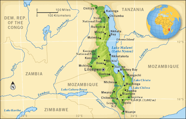
 MALAWI is a slender country formerly known as Nyasaland, situated in Southeastern Africa. There are 3 bordering countries: Mozambique, Tanzania, and Zambia. Malawi also borders Lake Nyasa, the 3rd largest lake in Africa. The capital and most-populated city is Lilongwe. The currency is the Malawian Kwacha, and its ISO 4217 currency code is MWK.
Blog Content
● The author of this GeoFact of the Day Blog creates and curates original, authentic content and posts information based on established facts. Blog posts are not generated by artificial intelligence (AI) but published by the author.
● Content and image graphics from other sources are properly credited. Many geography facts are well-established and therefore do not belong to any one source, but occasionally a fact requires attribution/credit if it is unique and hard-to-find — for example, facts found from specific cultural, anthropological, geological, and scientific (etc.) research.
● I do not copy and paste from other websites. Therefore, all posts are original but may sometimes include information, links, and/or images from credited external sources. To use a GeoFact of the Day Blog image for your website or project, write a comment below a post — then I may approve your request.
● Feel free to offer comments, suggestions, and compliments on any post or page! You can be anonymous. Spam comments with non-relevant links will be deleted.
● Thanks for your loyal readership on the educational and reliable GeoFact of the Day Blog, in existence since 2008!


