Search for Posts, Maps, and Topics

 GUATEMALA is located in Central America. Guatemala's bordering countries are Belize, El Salvador, Honduras, and Mexico. It also borders the Pacific Ocean as well as the Gulf of Honduras in the Caribbean Sea. The capital is Guatemala City (Ciudad de Guatemala), which has over 900,000 residents. The currency is the Guatemalan Quetzel; the ISO 4217 currency code is GTQ. Guatemala is famous for being the center of Mayan civilization and features a plethora of ancient temples, Mayan pyramids, and historic civilizations.
 With an area of about 8,124 square miles or 21,041 square kilometers, EL SALVADOR is a relatively small country located in Central America. El Salvador's bordering countries are Guatemala to the northwest and Honduras to the north and east. El Salvador also borders the Pacific Ocean along its southern coastline. The capital and largest city in terms of population is San Salvador, which has over 2,000,000 residents in the metro area. The currency was the Salvadorian Colón, and its ISO 4217 currency code was SVC. El Salvadorans currently use the United States Dollar.
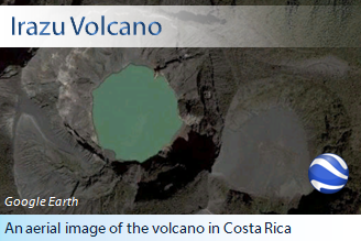
The Irazú Volcano, which is just down the road from the capital of COSTA RICA (San José), is surely a sight to see in aerial photography and in real life!
 COSTA RICA is a rainforested country and popular tourist spot located in Central America. Costa Rica's bordering countries are Nicaragua and Panama. It also borders the Caribbean Sea on the right coast and the Pacific Ocean on the left coast. The capital is San José, which has almost 900,000 residents. There is a volcano named Volcán Irazú just to the right of the capital. Also, Costa Rica is known as Rich Coast in Spanish - the country's official language. The currency is the Costa Rican Colón, and its ISO 4217 currency code is CRC.
")
Top Map Credit: © 2010 GeoFact of the Day
Bottom Map Credit: ™ & © 2017 Scholastic Inc. (go.grolier.com/atlas)
Click on the bottom map to enlarge it in a new tab or window.
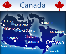
CANADA is the second largest country in the world and is located in northern North America. Canada's only other bordering country is the United States. The capital is Ottawa, which has over 800,000 people. The largest city population-wise in Canada is Toronto, followed by Montreal, Calgary, Edmonton, Winnipeg, Mississauga, and Vancouver. The currency is the Canadian Dollar, and its ISO 4217 currency code is CAD. Visit more Canada-labeled posts on the GeoFact of the Day Blog! This link opens in a new tab or window.
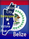 Located in Central America, BELIZE is one of the least-densely populated countries in the world. Belize's bordering countries are Guatemala and Mexico. Belize is known for attempting to protect its offshore coral reefs, boasting biodiverse rainforests, and featuring multiple ancient Maya archaeological sites of interest. The capital is Belmopan, which only has approximately 16,000 residents. The currency is the Belize Dollar, and its ISO 4217 currency code is BZD.
 AUSTRALIA is a continent and country located between the Indian Ocean to the west and the South Pacific Ocean to the east. Australia's nearby countries include East Timor (Timor-Leste), Indonesia, New Zealand, and Papua New Guinea. Between the cities of Darwin and Cairns is the Gulf of Carpentaria. The Great Australian Bight takes a bite out of southern Australia! Below mainland Australia is the island of Tasmania, whose capital is Hobart. The largest town in Australia, Sydney, has a population of 4,500,000. The national capital is Canberra. According to Encyclopædia Britannica, Australia’s population in the year 2020 is about 25,743,000 and is ranked 52nd among populations of the whole world’s countries, dependencies, and territories. The currency is the Australian Dollar, and its ISO 4217 currency code is AUD. For some basics about Lake Eyre in southern Australia, visit my Lake Eyre post.
")
Map Credit: © Maps of the World (mapsofworld.com)
Click on map to enlarge it in a lightbox window.
Officially named the Bolivarian Republic of Venezuela (República Bolivariana de Venezuela), VENEZUELA is a Spanish-speaking country situated in northern South America, south of the Caribbean Sea. Bordering countries are Brazil located south and southeast of Venezuela, Colombia to the west, and Guyana to the east. The island country Trinidad and Tobago, islands belonging to the Netherlands (Aruba, Bonaire, and Curaçao), and smaller islands are located north of Venezuela in the Caribbean Sea. Venezuelans annually celebrated Independence Day since July 5th in 1811, when the nation declared independence from Spain.
● ● ● ● ● People and Places ● ● ● ● ● The capital of Venezuela is Caracas, which has a population around 2,100,000. Other large cities in Venezuela include Ciudad Guayana, Maracaibo, Mérida, San Cristóbal, and Valencia. For their currency, Venezuelans use the Venezuelan Bolívar. The ISO 4217 currency code is VEF. Indigenous Indian groups in Venezuela, including but not certainly not limited to Baniwa, Barí, Warao, Wayuu, and Yaruro tribes, speak about 25 languages. They typically inhabit western and southern Venezuela, especially the provinces of Zulia (west) and Amazonas (south). Spanish is the national and official language, while English has become the second most spoken language. Religion-wise, most Venezuelans are Roman Catholics while indigenous people continue worshipping their own religions and beliefs.
● ● ● ● ● Land Features ● ● ● ● ● Venezuela has some neat land geography facts. Standing at almost 980 meters and over 3,000 feet in the Bolívar state of southeastern Venezuela, the world-renown Angels Falls is the tallest waterfall with no interruptions. Lake Maracaibo in northwestern Venezuela is generally considered a lake even though it is technically a bay. The northernmost land-connected extension of Venezuela, the Paraguaná Peninsula features the Paraguaná Refinery Complex. This refinery facility is one of the largest oil refineries in the world. Another major peninsula of Venezuela jutting out into the Caribbean Sea is Paria Peninsula, also known as Peninsula de Paria ↗ (blog post link). This peninsula is about 1,000 kilometers east of Paraguaná Peninsula and just west of Trinidad and Tobago. The Andes Mountains (Cordillera de los Andes in Spanish) stretch from southwest to northeast across western Venezuela. Pico Bolívar is Venezuela's highest peak, standing tall at over 5,000 meters and over 16,400 feet.
")
Map Credit: © Maps of the World (mapsofworld.com)
Click on map to enlarge it in a lightbox window.
Officially known as the Eastern Republic of Uruguay (República del Oriental del Uruguay), URUGUAY is a Spanish-speaking country situated in southern South America and west of the South Atlantic Ocean. This country on the eastern (specifically southeastern) coast of South America symbolizes the rising sun by featuring one on its national flag. Argentina is found to the west of Uruguay, while the state of Rio Grande do Sul in southern Brazil is north. Uruguay's currency is the Uruguayan Peso, and its ISO 4217 currency code is UYU. Uruguay declared independence from Brazil on Thursday, August 25th, 1825, and Uruguayans therefore celebrate an annual Independence Day on August 25th.
● ● ● ● ● People and Places ● ● ● ● ● From a 2014 estimate, the total population of the country is about 3.42 million and growing. Uruguay's official and primary language is Spanish, which is spoken by at least 3 million Uruguayans and therefore almost 90% of the total population. Other spoken languages include German, Yiddish, English, and less frequently Guaraní. The country's name is a possible Guaraní derivative meaning "river of the painted birds." Uruguay once boasted a diverse native Amerindian population; former native groups of people included Arachán, Bohán, Chaná, Charrúa, Güenoa, Minuane, and Yaro. Less than 3% of the population might have some Amerindian heritage and ancestry. Christianity is the majority religion, with about 65% of the population identifying as Christians (majority Roman Catholic).
The capital of Uruguay is Montevideo, which has a population of over 1,300,000. Other cities in the country include Achar, Artigas, Belle Unión, Carmelo, Castillos, Cebollatí, Colonia del Sacramento, Dolores, Durazno, Florida, La Paloma, Melo, Mercedes, Paso de los Toros, Paysandú, Punta del Este, Río Branco, Rivera, Rocha, San Carlos, San José de Mayo, Santa Lucía, Treinta-y-Tres, Tres Arboles, and Velázquez. Interesting places in Montevideo include the Ciudad Vieja (Old City) district, El Prado and other parks (parques), Grande Parque Central soccer stadium, Plaza Independencia (Independence Plaza), and Punta del Este and other beaches (playas). Other sites of interest in Uruguay include the Acuamania and Termas De Salto Grande water parks in Salto, Establecimiento Juanico (a winery) in Canelones, Fortaleza de Santa Teresa (a fortress) in Rocha, beach of José Ignacio, and Puente Giratorio (a bridge near favorable picnicking areas) in Carmelo.
● ● ● ● ● Land Features ● ● ● ● ● Shared with Argentina, the Río de la Plata (River of Silver) river and estuary serves as Uruguay's southern border and is the famous natural feature adjacent to Buenos Aires (Argentina's capital). Rivers such as Arroyo del Sauce, Paraná, Rosario, Santa Lucia (still heavily forested), and Uruguay flow from the Río de la Plata, which is about 50 kilometers wide. Also known as Cuchilla de Haedo and Haedo Hills, the Haedo Range is found in northern Uruguay. Meanwhile, the granite hills of the Grande Range (Cuchilla Grande) are found in southeastern Uruguay — about 100 kilometers away from Montevideo. Río Negro (Black River) flows a teeny bit in southern Brazil before reaching the land of northeastern Uruguay, where this river then flows diagonally to meet up with Río Uruguay (Uruguay's southwestern border). Located at the heart of Uruguay, Lago Rincón del Bonete (Rio Negro Reservoir) is the country's largest freshwater lake and was created by damming the Rio Negro. While neighboring Argentina's highest mountain (Anconagua) is over 6,900 meters and 22,800 feet tall in elevation, Uruguay's highest mountain is much shorter. Located in the aforementioned Grande Range of hills, Cerro Catedral (Cathedral Hill) stands about 514 meters and 1,685 feet tall in southeastern Uruguay's Maldonado Department.
This post was updated with more information on May 20th, 2016.
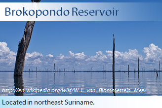
Dead trees are remnants of a former rainforest destroyed by the man-made creation of the Brokopondo Reservoir, located in northeast SURINAME (in South America) in 1965.
 SURINAME is a relatively small country located in northern South America. Suriname's bordering countries are Brazil, French Guiana, and Guyana. It also borders the North Atlantic Ocean. The capital is Paramaribo. The currency is the Surinamese Dollar, and its ISO 4217 currency code is SRD.
 PERU is an Andes-straddling country located in western South America. Peru's bordering countries are Bolivia, Brazil, Chile, Colombia, and Ecuador. It also borders the Pacific Ocean and is just south of the Equator. The capital is Lima, which has a population of at least 7 million. The currency is the Peruvian Nuevo Sol, and its ISO 4217 currency code is PEN.
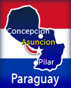 PARAGUAY is a landlocked nation located in south-central South America. Paraguay's bordering countries are Argentina, Bolivia, and Brazil. The capital is Asuncion. The currency is the Paraguayan Guarani (Guaraní), and its ISO 4217 currency code is PYG. The Guarani's currency sign ₲. Paraguay is one of the world's largest exporter of soybeans, being the third largest recently.
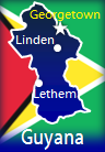 GUYANA is a relatively forested and sparsely-populated country located in Northern South America. Guyana's bordering countries are Brazil, Suriname, and Venezuela. It also borders the North Atlantic Ocean along its northern coast. With about 235,000 residents in 2012, the national capital is Georgetown. According to Encyclopædia Britannica, Guyana’s population in the year 2020 is about 744,300 and is ranked 166th among populations of the whole world’s countries, dependencies, and territories. The currency is the Guyanese Dollar, and its ISO 4217 currency code is GYD. Guyana has been fought over and claimed by the British, Dutch, French, and the Spanish during past centuries.
 FRENCH GUIANA is an overseas territory of France located in Northern South America. French Guiana's bordering countries are Brazil to the south and east and Suriname to the west. Its northern coast borders the North Atlantic Ocean. As this Suriname border dispute post (opens in new tab/window) reveals, Suriname claims a portion of French Guiana west of the Marouini River.
● ● ● ● ● People and Places ● ● ● ● ● The capital and largest city is Cayenne, which has less than 60,000 residents and is located along the Atlantic coast. Other communities scattered throughout French Guiana include Cacao, Camopi, Citron, Grand Santi, Iracoubo, Kaw, Kourou, Maripasoula, Montsinéry, Ouanary, Régina, Roura, Saint-Élie, Saint-Georges, Saint-Jean, Saint-Laurent du Maroni, Saül, Sinnamary, and Tonate. The French Guianese people use the Euro currency, the same currency used in France. French is the official language, and other European languages spoken in French Guiana include Dutch, English, Portuguese, and Spanish. Other languages include French Guianese Creole, Maroon dialects, and various indigenous languages. Residents living in French Guiana are mostly Creoles, people with African ancestry, and native American Indians. Others include folks from countries such as Brazil, China, and France.
● ● ● ● ● Land Features ● ● ● ● ● About 9/10 of French Guiana, especially the southern area, is covered by equatorial rainforests. Rivers flow throughout the rainforests. In addition to Marouini River mentioned above, rivers include Approuague, Camopi, Lawa, Litani, Mana, Maroni, Oyapock, Sinnamary, and Tampoc. Lawa, Litani, and Maroni rivers form the western border with Suriname, while Oyapock forms part of the eastern border with Brazil. French Guiana's highest point is Bellevue de l'Inini, which stands 851 meters tall (almost 2,800 feet) in south-central French Guiana east of the town Maripasoula. The small Îles du Salut (Islands of Salvation) are located near the coastline north of Kourou. Colloquially known as "Devil's Island," the Îles du Salut served various functions for the penal colony. There are also small islands near Cayenne.
● ● ● ● ● Guiana Space Centre ● ● ● ● ● Operated by the European Space Agency, the Guiana Space Centre (Centre Spatial Guyanais) in Kourou was chosen for its ideal location. Since Kourou is near the Equator, satellites launched into orbit do not need as many trajectory adjustments compared to satellites launched farther away from the Equator.
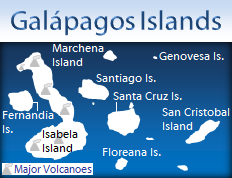
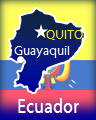 ECUADOR is a relatively small country situated in northwestern South America. Ecuador's bordering countries are Colombia and Peru. It also borders the Pacific Ocean at and near the Equator. The capital is Quito. According to Encyclopædia Britannica, Ecuador’s population in the year 2020 was about 17,537,000 and was ranked 68th among populations of the whole world’s countries, dependencies, and territories. The currency was the Ecuadorian Sucre, but since 2000 Ecuadorians are mostly using the United States Dollar. A great asset to Ecuador is the owning of the Galápagos Islands, which are home to many unique and rare species and offered Charles Darwin the chance to discover more about natural selection and species evolution. There are over 30,000 people living on the islands.

● ● ● ● ● People and Places ● ● ● ● ● From a 2015 estimate, the total population of Colombia is approximately 49 million and growing. Colombia's population growth from the 1970s to today is almost perfectly linear when plotted on a graph. With over 7.6 million residents, Colombia's capital and most-populated city is Bogotá. Cali and Medellín cities have over 2 million residents, while Barranquilla is home to about 1.15 million people. Other major cities include Armenia, Bucaramanga, Cartagena, Cúcuta, Florencia, Ibagué, Manizales, Montería, Neiva, Pereira, Popayán, Quibdó, Ríohacha, San Juan de Pasto (Pasto), Soacha, Soledad, Tunja, Turbo, Uribía, Valledupar, Villavicencio, and Zipaquirá.
Spanish is Colombia's official and most-spoken language. Almost 90 languages are spoken in Colombia, most of which correspond to particular native tribes. These languages include Achagua, Awa-Cuaiquer, Barí, Camsá, Emberá (several dialects), Guahibo, Malayo, Nhengatu, Páez, Sáliba, Totoro, Tucano, Tunebo (several dialects), Wayuu, and Yukpa. Catalan and Vlax Romani are a couple of minor immigrant languages found in Colombia. As of 2015, the literacy rate is 94%. Christianity — especially Roman Catholicism — is the religion that most Colombians believe in, followed by Spiritism, ethnic indigenous religions, and Bahá'í.
● ● ● ● ● Land and Water Features ● ● ● ● ● Jutting northward into the Caribbean Sea is Península de la Guajira (Guajira Peninsula), separated from Venezuela's Península de la Paraguaná by the Golfo de Venezuela (Gulf of Venezuela). Known for its orange-colored sand dunes, Macuira National Park is located on this peninsula. At the tip of Guajira Peninsula is mainland South America's northernmost point, Punta (Point) Gallinas. While the Amazon Rainforest is famously known for being in Brazil, this biodiverse world wonder also stretches into eastern Colombia and provides a home for over 3,000 species as well as native Amerindians.
Some of the country's longest rivers (ríos) — including Ajaju, Caquetá, and Putumayo — are located within Colombia's Amazon Rainforest and eventually flow to the Amazon River. Arauca, Guainía, Guaviare, Meta, and other rivers eventually flow to the Orinoco river — which travels along the eastern Colombia-Venezuela border before reaching into northern Venezuela. Meanwhile, northern Colombia's Magdalena river flows northward past large marshes (cienagas) before reaching the Caribbean Sea. With a geographic surface area greater than 55 square kilometers and about 21 sq. miles, Laguna de Tota (Lake Tota) is Colombia's largest lake and is located northeast of Bogotá and south of Bucaramanga.
Volcanoes (volcáns in Spanish) straddle the Andes mountain range, which is the case in other South American countries such as Ecuador, Peru, and Chile. Mostly located in southwestern and western Colombia, volcanoes include Azufral, Bravo, Cerro Negro de Mayasquer, Chiles, Galeras, Huila, Machín, Ruiz, and Tolima. According to the Volcano Discovery website, Ruiz volcano (Nevado del Ruiz) is erupting with mild to moderate ash emissions as of June 28th, 2016. Ruiz's last eruption in 1985 tragically resulted in the deaths of more than 20,000 people. Located near Pasto in southwestern Colombia, the frequently active Galeras volcano last erupted in 2006, 2008, and 2010 and is the first-known active volcano to deposit gold near its crater. Nine people (scientists and tourists) unfortunately perished in a 1993 eruption of Galeras.
Subdivided into the Cordillera Occidental, Cordillera Central, and Cordillera Oriental (east) mountain ranges, the Andes run across southwestern and western Colombia and northeastward toward Venezuela — stopping at the Sierra Nevada del Cocuy highlands near Bucaramanga. Colombia's highest point is Pico Cristóbal Colón, a mountain towering about 18,950 feet and 5,775 meters in total elevation. This peak is found in the Sierra Nevada de Santa Marta mountain range and national park, located between Santa Marta and Valledupar near the Caribbean Sea.
This post was completely updated — including a new map — on July 25th, 2016.

 CHILE is a vertically skinny nation straddling the Andes mountain range. Chile is east of the South Pacific Ocean in southwestern South America. Chile's bordering countries are Argentina to the east, Bolivia to the northeast, and Peru to the north and northwest. Chile's southern coastal area is comprised of hundreds of islands - including Archipiélago Reina Adelaida (Queen Adelaide Archipelago) and Isla Tierra del Fuego - separated by somewhat narrow straits. Among those islands are the Straits of Magellan, which Ferdinand Magellan sailed through in 1520. Also known as Isla Grande de Tierra del Fuego and simply Tierra del Fuego (land of fire in Spanish), Isla Tierra del Fuego sits along the vertical Chile-Argentina border. Occupying the island's western portion, Chile shares the island with Argentina. Cape Horn marks the southern land-based extent of South America. Almost 3500 kilometers (about 2200 miles) north of Cape Horn is the arid Atacama Desert, featuring the world's most driest locations. At the border with Argentina in northeastern Chile, Ojos del Salado (eyes of salt in Spanish) stratovolcano stands tall at over 8,700 meters (over 22,600 feet) in height and is designated as Chile's highest point. Chile's capital and largest city in terms of population is Santiago. Chile's currency is the Chilean Peso. The peso's ISO 4217 currency code is CLP.


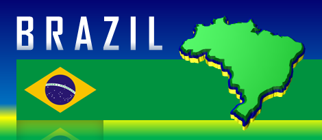
● ● ● ● ● People and Places ● ● ● ● ● Most of Brazil's major cities are found along the coast of the North Atlantic Ocean and South Atlantic Ocean, including Belém, Fortaleza, João Pessoa, Macapá, Maceió, Natal, Olinda, Porto Alegre, Recife, Rio de Janeiro, Salvador, São Luís, São Paulo, and Vitória. Sao Paulo is the most popular city with about 10.7 million residents as of 2016, followed by Rio de Janeiro (5.95 million) and Salvador (2.49 million). The capital with about 2.5 million residents (2016) is Brasília, located in southeast-central Brazil and in the Distrito Federal (Federal District) — surrounded by the states of Goías (north, south, and west) and Minas Gerais (east). Other major inland cities besides Brasília include Belo Horizonte, Campo Grande, Cuiabá, Goiânia, Ji-Paraná, Manaus, and Maraba.
Portuguese is Brazil's official language, and it is universally spoken in the country. Meanwhile, 2,000,000 total Brazilians speak Italian, German, and other European languages. Native indigenous groups and their respective languages include Canela, Guajajára, Guaraní (currently the largest tribe in Brazil), Hixkaryána, Jamamadí, Kaiwá, Maxakalí, Ticuna, Tucano, Xavánte, and Yąnomamö. Meaning "land of the palm trees," Pindorama is the Guaraní name for Brazil. The literacy rate of Brazil — as of the year 2015 — is 91.5%. Over 90% of Brazilians are Christians, followed by Spiritism (5%), Buddhism (0.25%), and Judaism (0.21%).
● ● ● ● ● Land and Water Features ● ● ● ● ● Brazil encompasses a large central and eastern portion of the Amazon Rainforest, subjected to deforestation and conversion to farmland but recovering in some areas. The Amazon River (Rio Amazonas, also Rio Solimões) flows about 2,845 kilometers and 1,768 miles through Brazil and for a total length of about 6,400 kilometers (4,000 miles). In Brazil, this mighty river begins its journey near the tri-state border at Brazil, Colombia, and Peru in the state of Amazonas. The Amazon River flows eastward along the border of Amapá and Pará states into the Atlantic Ocean. Near the coastal city of Macapá, the Amazon diverts itself into an estuary connected to the Atlantic Ocean. Amazon River tributaries include Juruá, Madeira, Tapajós, and Xingu.
Located in the Guiana Highlands and specifically in northwestern Brazil near Venezuela, Pico da Neblina is Brazil's highest point and stands about 2,995 meters and 9,825 feet in elevation. Essentially named Ducks Lagoon in English, Brazil's largest lake is Lagoa dos Patos (Patos Lagoon), which is situated northeast of Uruguay and in between the cities of Porto Alegre (northern shore), Pelotas (southern shore), and Rio Grande (southern shore). The name may come from the notion that 16th-century Jesuit missionaries wanted to conduct duck breeding operations in this lagoon. The 14,000-square-mile lagoon's southern outlet to the Atlantic Ocean is more than 1 kilometer in width and is typically cloudy with sediments and pollution.
This post was updated with more information and a new map on August 17th, 2016.

Occasionally, the GeoFact of the Day blog will show a highlight photo relating to the week.
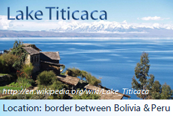
Lake Titicaca, the highest commercially-navigable lake in the world, is arguably a one of the most spectacular sights of clear-blue water in the whole world. This high-altitude lake straddles the border of BOLIVIA and PERU.
")
Map Credit: © Maps of the World (mapsofworld.com)
Click on map to enlarge it in a lightbox window.
Officially known as the Plurinational State of Bolivia, BOLIVIA is a landlocked country located in the central region of South America. Bolivia's bordering countries are Argentina to the south, Brazil to the northeast, Chile to the southwest, Paraguay to the southeast, and Peru to the west. Paraguay is the only other South American landlocked state. Even though it is completely surrounded by land, Bolivia is close to coastal access with the Pacific Ocean. Only a small area of northern Chile and southern Peru block Bolivia from the coast. In addition, Bolivia was not always landlocked. In the late nineteenth century, the country lost its coastal area to Chile in the War of the Pacific (Guerra del Pacífico). Bolivia's currency is the Bolivian Boliviano, and its ISO 4217 currency code is BOB.
● ● ● ● ● People and Places ● ● ● ● ● Bolivia's total population is about 10,725,000, based on 2015 data. Unlike most countries, some Bolivians live in two capital cities: La Paz (administrative capital) and Sucre (constitutional capital). La Paz (the word Peace in English) is the highest capital city in the world since it stands over 12,000 feet above sea level. Other Bolivian cities include Cochabamba, El Alto (immediately west of La Paz), Oruro, Potosí, and Santa Cruz. About 43 languages are spoken in Bolivia. Due to the country's linguistic and ethnic group diversity, languages such as Aymara, Ayoreo (a Zamucoan language), Chácobo, Chiquitano (Bésiro), Guaraní, Machinere, Quechua, Sirionó, Tapieté, and Uru are native official languages, which are less widely spoken than Spanish (another official language). Even extinct languages with no native speakers — Canichana, Cayubaba (Cayuvava), Pauserna-Guarasugwé, and Puquina — are designated as official languages. Bolivia's literacy rate is about 95%, a rate similar to the percentages of Paraguay and Peru but higher than Brazil (91.5%) and Guyana (85%) and lower than Argentina (98%), Chile (96.7%), and Uruguay (98.4%).
Most religious people are Christians, who are predominantly Roman Catholic and comprise about 90% of Bolivia's total population. About 350,000 or more Bolivians adhere to tenets and beliefs in ethnic religions, and over 200,000 citizens are Bahá'í believers. Bolivia boasts multiple landmarks and sites of interests, particularly statues, churches, and sites of ancient civilizations. Did you know that the Cristo de la Concordia (Christ of Peace) is the world's second-largest Jesus Christ statue, standing over 40 meters (about 133 feet) above the ground and taller than Brazil's Christ the Redeemer monument? Located on San Pedro Hill east of Cochabamba city, Bolivia's concrete behemoth is slightly shorter than Świebodzin, Poland's circa-2010 Christ the King statue. Other sites of interest include Biocentro Güembé (Santa Cruz), House of Liberty Museum (Sucre), Iglesia de San Francisco (La Paz), Mariscal Antonio Jose de Sucre suspension bridge, Metropolitan Cathedral of La Paz, Metropolitan Cathedral of Sucre, Palacio Portales (Cochabamba), Plaza 25 de Mayo (Sucre), Presidential Palace (La Paz), and the Tiwanaku ancient civilization site.
● ● ● ● ● Land Features ● ● ● ● ● Bolivia is particularly known for its location along South America's major mountain range, two large salt flats, and a well-known lake. Lake Titicaca (Lago Titicaca) is the largest lake within Bolivia's border, specifically located on the western border with southern Peru. It is often known as the world's highest navigable lake at 12,500 feet in elevation, and this lake's surface area is about 8,366 square kilometers (3,230 sq. miles). Meanwhile, this lake boasts the largest volume in South America. The second largest lake and largest one completely within the country, Lake Poopó is south of Oruro and boasts a surface area of 1,339 sq. kilometers (517 sq. miles).
Stretching across southwestern Bolivia and mostly into northern Chile, the Atacama Desert serves as the home for Bolivia's two largest salt flats: Salar de Uyuni (largest in the world) and Salar de Coipasa . Sometimes known as Uyuni Salt Flat in English, Salar de Uyuni steals the spotlight in many National Geographic photos. It is located in Potosí Department and surrounded by communities such as Ayque, Calo, Carpas, Chuvica, Coqueza, and of course Uyuni. Salar de Coipasa is sometimes filled with water and therefore also called Lago de Coipasa; it is located north of Salar de Uyuni in Oruro Department. The Abuná River (Río Abuná) forms the northern border with Brazil, while Río Iténez straddles the northeastern Bolivia-Brazil border.
Bolivia is one of seven South American countries straddling the Andes Mountains. Some of the country's major Andes sub-ranges include the Cordillera Central, Cordillera Occidental (west), Cordillera Oriental (east), Cordillera de los Frailes, and Cordillera de Lípez. Located near the northern Chilean border in Oruro Department, Nevado Sajama is Bolivia's highest peak and is currently a non-active (extinct) stratovolcano. The peak features an elevation of 6,542 meters and 21,463 feet and is the obvious highlight of Parque Nacional Sajama (Sajama National Park). Other volcanoes include Acotango (potentially active), Cerro Guacha, Cerro Lípez, Iru Phutunqu (potentially active), Paruma (potentially active), Umurata, and Zapaleri.
This post was updated with more information on April 5th, 2016.

 One of the southernmost countries in the world, ARGENTINA is located in the southern region of South America. Argentina's bordering countries are Bolivia to the north and northwest, Brazil to the northeast, Chile to the west, Paraguay to the north, and Uruguay to the east. Argentina also borders the South Atlantic Ocean. Argentina's currency is the Argentinean Peso, and its ISO 4217 currency code is ARS.
● ● ● ● ● People and Places ● ● ● ● ● According to Encyclopædia Britannica, Argentina's population in the year 2020 is about 43,377,000 and is ranked 30th among populations of the whole world’s countries, dependencies, and territories. Argentina's capital is Buenos Aires ("good air"), which is located west of the Río de la Plata ("river of silver") and the Atlantic Ocean. Buenos Aires is also located southwest of Uruguay. As of 2015, 3 million residents live in Buenos Aires. Other major cities throughout Argentina include Córdoba, La Plata, Mendoza, Rosario, Salta, Tucumán, and Ushuaia. A majority of Argentinians — anywhere from 60% to 97%, depending on the information source and definition — have ancestral heritage of European and non-European Caucasian people. At least 10% of residents are of partial or whole indigenous ancestral descent. Native indigenous groups in Argentina include the Aymara, Guaraní, Mapuche (Mapudungu), Quechua, Qulla, and Wichí people. Over 95% of Argentinians speak Spanish (official language), about 1% can speak German, and other residents speak indigenous languages. 92% of religious Argentinians are Roman Catholic, followed by Islam at about 2% and Judaism at 1.3%.
Post Link: UNESCO World Heritage Sites in Argentina
● ● ● ● ● Land and Water Features ● ● ● ● ● Ushuaia, the southernmost city in the world, is located on Isla Grande de Tierra del Fuego, the triangular Tierra del Fuego archipelago's largest island. Tierra del Fuego translates to "land of fire," named by Ferdinand Magellan when he discovered smoke rising from campfires built by native islanders. The island's western section belongs to Chile. East of this island is Isla de los Estados, which forms the archipelago's eastern extent. Other islands in this archipelago — including Isla Clarence, Isla Dawson, Isla Gordon, Isla Hoste, and Isla Navarino — belong to Chile. With a total length of about 4,880 kilometers and 3,032 miles, Paraná River is South America's second-longest river and the longest river flowing through Argentina. Other rivers include Chico, Colorado, and Uruguay.
Standing near the Argentina-Chile border in Mendoza Province, Argentina's highest point is Mount Aconcagua (Cerro Aconcagua). Aconcagua stands about 6,960 meters and over 22,830 feet in elevation within the Southern Andes mountains. Other mountains — some of which are also volcanoes — which straddle the country's western border include Cerro Bonete, Llullaillaco (also a historically active volcano), Cerro Mercedario, Monte Pissis (also an extinct volcano), Ojos del Salado (also a stratovolcano), and Volcán Tupungato (also a stratovolcano).


 Officially known as the Republic of Zimbabwe, ZIMBABWE is a landlocked country located in Southern Africa. Zimbabwe borders five countries: Botswana located to the southwest, Mozambique to the east, South Africa to the south, and Zambia to the north. Zimbabwe almost borders Namibia to the west. Along the Zimbabwe-Zambia border, the country possesses part of Lake Kariba, the Zambezi River, and the magnificent Victoria Falls. Zimbabwe’s former currency was the Zimbabwean Dollar, which had an ISO currency code of ZWL. Due to hyperinflation, Zimbabweans were and still are using other currencies to complete transactions. In June 2015, the Central Bank officially withdrew the currency from circulation. Zimbabwe is the world’s last country in alphabetical order!
● ● ● ● ● People and Places ● ● ● ● ● Over 11.652 million residents live in Zimbabwe, while 1,190,000 urbanites live in the national capital: Harare. Other major cities include Bulawayo (population: 622,000), Chitungwiza (275,000), Gweru (125,000), Hwange, Masvingo, Mutare (132,000), and Shurugwi. While Zambia is known for its diverse variety of ethnic groups, Zimbabwe is predominantly shared between Shona (over 80%) people, Ndebele (14%) people, and several other minority groups. About twenty-one major languages are used for communication — including two (Barwe and Tsoa) that are facing a threatened existence in the future. Languages include Chichewa, Dombe, Kalanga, Kunda, Lozi, Manyika, Nambya, Ndau, Ndebele, Shona, Tonga, Tswana, and Venda. Zimbabwe's literacy rate is relatively high (84%) in Africa. About 70% of religious Zimbabweans are Christians and 0.75% are Muslims. About 30% of Zimbabweans adhere to native beliefs and customs.
Great Zimbabwe (southeast Zimbabwe) and Dhlo-Dhlo (south-central Zimbabwe) are two ancient Shona civilization sites with still-standing stone walls and towers. Standing about 10.05 meters and 33 feet tall in Great Zimbabwe, the prominent conical tower is attached to walls of the Great Enclosure — known as the largest pre-colonial structure in Sub-Saharan Africa. Another ancient site and tourist attraction is located at Khami, a current UNESCO World Heritage Site and ancient capital of the Kingdom of Butua — organized by the ancestors of Kalanga (Shona-related) people. Zimbabwe’s national parks include Chewore Game Preserve (north), Chizarira NP (northwest), Gonarezhou NP (southeast), Hwange NP (west), Kazuma Pan (west), Mana Pools NP (north), Matabo NP (southwest), Matusadona NP (NW), Mtarazi Falls NP (east), and Zambezi NP (Zimbabwe’s western tip).
● ● ● ● ● Land Features ● ● ● ● ● Zimbabwe’s major waterfalls are on opposite sides of the country. People can find the Mtarazi Falls and Pungwe Falls in eastern Zimbabwe, while tourists would want to visit western Zimbabwe to witness the world-famous Victoria Falls. There’s more than waterfalls in Zimbabwe! Non-water land features include the northern Chinhoyi Caves, northwestern Chizarira Hills, central Mafungabusi Plateau, southern Mateke Hills, eastern Mavuradonha Mountains (near NW Mozambique), and northern Zambezi Escarpment. The Chinhoyi Caves are located about 150 kilometers northwest of Harare, while the Zambezi Escarpment is further north and runs westward into Zambia. Located in eastern Zimbabwe near Mozambique, Mount Nyangani is Zimbabwe's highest peak and stands 2,592 meters and 8,504 feet in elevation. Nyangani is comprised of harder dolerite and softer sandstone.
This post was updated with more information in September 2016. GeoFact of the Day’s map of Zimbabwe was designed in December 2022.

● ● ● ● ● People and Places ● ● ● ● ● Based on the GeoFact of the Day Blog’s 2016 estimate, Zambia’s total population is approximately 12,060,000 and growing. Located in south-central Zambia less than 100 kilometers away from Zimbabwe, the capital and most-populated city is Lusaka with about 982,000 residents. Other Zambian cities include Chingola (170,000), Choma, Kabwe (population: 168,000), Kasama, Kitwe (247,000), Livingstone, Lundazi, Mbala, Ndola (377,000), Serenje, and Zambezi.
Zambians culturally identify themselves in over 70 ethnic groups of people — including the Bemba, Kaonda, Lozi, Ngoni, and Tonga ethnicities. While English is used as an official language by some citizens and for government purposes, Zambians speak about 70 native ethnic languages, many of which correspond to the namesake ethnic tribe. Major native languages include Bemba, Kaonda, Lozi, Lunda, Luvale, Nyanja, and Tonga. At least one-half of religious citizens are Christian, while one-fourth of people are Hindu and Muslim adherents.
Protected and publically accessible national parks are scattered throughout the country. Parks in the northeastern “panhandle” include Isangano NP, Kasanka NP, Lavushi-Manda NP, Luangwa NP (split into north and south sections), Lukusuzi NP, Lusenga NP, Mweru-Wantipa NP, and Nsumbu NP. Other national parks include Blue Lagoon and Lochinvar national parks (south-central Zambia), the large Kafue NP (west-central Zambia), Liuwa Plain NP (west), Lower Zambezi NP (southeast), Sioma Ngwezi NP (southwest), and West Lunga NP (northwest).
● ● ● ● ● Land Features ● ● ● ● ● Aquatic and physical features in northern and eastern Zambia include the Bangweulu Swamp, Chisimba Falls, Johnston Falls, Lake Bangweulu with Mbabala island, Lake Mweru with Kilwa island, Muchinga Mountains, and Sunzu mountain (elevation: 2,067 meters). Zambians and tourists alike enjoy dramatic cliff views of the Wonder Gorge, located in east-central Zambia along the Lusemfwa River. About 150 kilometers west lies the Lukanga Swamp, home to various endangered species and undoubtedly many pesky mosquitoes! Kuyamba Hills are northwest of the swamp, while the Mufulwe Hills are northeast of Wonder Gorge.
What is the highest point in Zambia, you might (or might not) ask? Well, the answer is unfortunately not 100% clear. On the border between eastern Zambia and western Malawi, Mwanda Peak (elevation: about 2,150 meters, 7,050 feet) is known as the Zambia border's highest point. Near the town of Mkushi in north-central Zambia, Mount Mumpu (1,950 meters, 6,400 feet) is known as the country's highest free-standing mountain. Interestingly, one of the routes up Mt. Mumpu traverses through one of Southern Africa's largest bat caves. Ultimately, though, the highest point designation likely belongs to Mafinga Central (according to Peakbagger.com and other sources) — boasting an elevation of 2,339 meters and 7,674 feet. Could there be an even higher point in Zambia somewhere? That could be a mystery yearning to be solved!
The ridge-like Zambezi Escarpment protrudes from southern Zambia into northern Zimbabwe. Its location is north of Lake Kariba, which stretches along the southern border with Zimbabwe. West and east of Lake Kariba, the Zambezi River stretches completely along the Zambia-Zimbabwe border. Before reaching southern Zambia, Zambezi begins in eastern Angola (location of its headwaters), then flows southward past the town of Zambezi and eventually reaches the borders of Namibia and then Zimbabwe. Arguably the most popular tourist attraction in Zambia, the Victoria Falls are along the Zambezi river in southwestern Zambia, near Zimbabwe’s western tip (see map). Other waterfalls are highlighted in the GeoFact of the Day Blog’s Waterfalls of Zambia post (↗).
This post was comprehensively updated on August 25th, 2016.
The map of Zambia was added on June 18th, 2017.
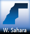 WESTERN SAHARA is a territory and non-country predominantly controlled by Morocco in Northwestern Africa. Three countries border Western Sahara: Algeria to the east (a small border), Mauritania to the south and east, and Morocco to the north. Western Sahara also borders the North Atlantic Ocean and is southeast of the Canary Islands. There is not a formal capital, but the largest city is Laâyoune. There are two currencies that W. Sahara uses: the Moroccan Dirham and Sahrawi Peseta, a locally issued currency.

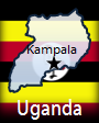 UGANDA is a landlocked country located in Eastern Africa. Democratic Republic of the Congo, Kenya, Rwanda, and South Sudan are bordering countries. Uganda also borders Lake Victoria, Africa's largest lake. There are other large lakes in Uganda, including Lake Albert and Lake Edward. The capital and most-populated city is Kampala. Other cities include Arua, Gulu, Kabale, Kisoro, Lira, Mbarara, Soroti, and Tororo. The currency is the Ugandan Shilling, and its ISO 4217 currency code is UGX.
 Officially called the Republic of Tunisia, TUNISIA (تونس, ⵜⵓⵏⴻⵙ, Tunisie*) is an Arabic- and French-speaking country located in Northern Africa. Algeria and Libya are the bordering countries. Tunisia also borders the Mediterranean Sea along its northern coastline. Two main islands with French influence belong to Tunisia: Ile de Djerba and Iles de Kerkennah. With well over 2 million residents in the metropolitan area, Tunisia's capital and most-populated city is Tunis. Other cities include Bizerte, Douz, Makthar, Meknassy, Monastir, Sfax, Tozeur, and Zarzis. Tozeur is north of Chott el Djerid, a salt lake that is Tunisia's largest lake. The currency is the Tunisian Dinar, and its ISO 4217 currency code is TND.
* Translations of the country's name in Arabic, Berber, and French


Above Left: Bordj el Kabir Fort, Djerba Island
Center: The Kerkennah Islands as seen in space
Right: A Coffeehouse on Djerba Island

 TOGO is a thin, French-speaking country located in West Africa. There are 3 bordering countries: Benin to the east, Burkina Faso to the north, and Ghana to the west. Togo also borders the Gulf of Guinea and the Atlantic Ocean along its southern coastline. The capital and most-populated city is Lomé. Other cities include Bassar, Guérin-Kouka, Kpèssi, Mango, Sokodé, Tabligbo, Tchamba, and Yégué. The currency is the West African Franc, and its ISO 4217 currency code is XOF.
")
Map Credit: © Maps of the World (mapsofworld.com)
Click on map to enlarge it in a lightbox window.
A prominent destination for adventures including safaris, the United Republic of TANZANIA (Swahili: Jamhuri ya Muungano wa Tanzania) is a country situated in Eastern Africa and west of the Indian Ocean. There are 7 bordering countries: Burundi, Kenya, Malawi, Mozambique, Rwanda, Uganda, and Zambia. It also borders Lake Victoria, Lake Tanganyika, and Lake Nyasa. The Democratic Republic of the Congo is located across from Lake Tanganyika. Worthwhile environmental destinations in Tanzania include the aforementioned lakes, Zanzibar and Pemba islands in the east, Ngorongoro Crater, the Serengeti plain, and Olduvai Gorge. The current capital is Dodoma, and the former capital was located at Dar es Salaam. The currency is the Tanzanian Shilling, and its ISO 4217 currency code is TZS.
Blog Content
● Content and graphics are created by me (pseudonym: Wonderful World), except when I credit other sources.
● I do not copy and paste from other websites. Therefore, all posts are original but may sometimes include information, links, and/or images from credited external sources. To use a GeoFact of the Day Blog image for your website or project, write a comment below a post — then I may approve your request.
● Feel free to offer comments, suggestions, and compliments on any post or page! You can be anonymous. Spam comments with non-relevant links will be deleted.
● Thanks for your loyal readership on the educational and reliable GeoFact of the Day Blog, in existence since 2008!


 With an area of about 8,124 square miles or 21,041 square kilometers,