

This particular alert has been cancelled. However, note that this area is still under a Tornado Watch and may have tornadic activity later on.
Tornado Warning
IAC095-103-183-300200-
/O.NEW.KDVN.TO.W.0025.190530T0108Z-190530T0200Z/
BULLETIN - EAS ACTIVATION REQUESTED
Tornado Warning
National Weather Service Quad Cities IA/IL
808 PM CDT Wed May 29 2019
The National Weather Service in the Quad Cities has issued a
* Tornado Warning for...
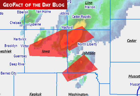
Southwestern Johnson County in east central Iowa...
North central Washington County in southeastern Iowa...
Southeastern Iowa County in east central Iowa...
* Until 900 PM CDT.
* At 808 PM CDT, a severe thunderstorm capable of producing a tornado
was located over Wellman, or 15 miles northwest of Washington,
moving northeast at 20 mph.
HAZARD...Tornado.
SOURCE...Radar indicated rotation.
IMPACT...Flying debris will be dangerous to those caught without
shelter. Mobile homes will be damaged or destroyed.
Damage to roofs, windows, and vehicles will occur. Tree
damage is likely.
* This dangerous storm will be near...
Kalona around 820 PM CDT.
Hills around 900 PM CDT.
Other locations impacted by this tornadic thunderstorm include
Frytown, Hills Access, Amish and Sharon Center.
PRECAUTIONARY/PREPAREDNESS ACTIONS...
TAKE COVER NOW! Move to a basement or an interior room on the lowest
floor of a sturdy building. Avoid windows. If you are outdoors, in a
mobile home, or in a vehicle, move to the closest substantial shelter
and protect yourself from flying debris.
&&
LAT...LON 4144 9183 4151 9189 4166 9165 4154 9150
TIME...MOT...LOC 0108Z 235DEG 17KT 4150 9182
TORNADO...RADAR INDICATED
HAIL...less than 0.75 IN
$$
Uttech
No comments:
Post a Comment