Search for Posts, Maps, and Topics

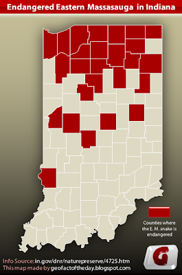
The Eastern Massasauga rattlesnake struggles to survive in certain areas where its vital habitat is being destroyed or harmed. The snakes typically live in wetlands but are also found in grassland and even dry pastures. They are mainly found in Midwestern states - particularly Illinois, Indiana, Michigan, Ohio, and Wisconsin - but the range of their presence extends eastward to New York, Pennsylvania, and southern Ontario (Canada) and westward to Iowa, Minnesota, and Missouri. In Indiana, most Eastern Massasauga populations live in Northern Indiana, which has more wetlands than the rest of the state. It may seem strange, then, that most of Northern Indiana's counties are in the region where the Eastern Massasauga is endangered. That is because ecologists, environmentalists, scientists, and geographers know there are E. M. populations in the dark red counties but have been seeing less and less of them - hence why they are considered endangered. In light-shaded counties, the snake species is extremely rare to find or extinct, although there are likely some counties with enough snakes to stay off the endangered list. It is difficult to approximate the populations in each county, partly because the snakes are not very noticeable when they are out and about.
These are the 26 dark red-colored counties where the Eastern Massasauga is considered endangered: Allen, Carroll, Cass, Delaware, Elkhart, Fountain, Fulton, Hamilton, Hendricks, Jasper, Kosciusko, LaGrange, Lake, LaPorte, Marshall, Montgomery, Noble, Porter, Pulaski, Saint Joseph, Starke, Steuben, Sullivan, Wabash, Wells, and Whitley.
Blog Content
● The author of this GeoFact of the Day Blog creates and curates original, authentic content and posts information based on established facts. Blog posts are not generated by artificial intelligence (AI) but published by the author.
● Content and image graphics from other sources are properly credited. Many geography facts are well-established and therefore do not belong to any one source, but occasionally a fact requires attribution/credit if it is unique and hard-to-find — for example, facts found from specific cultural, anthropological, geological, and scientific (etc.) research.
● I do not copy and paste from other websites. Therefore, all posts are original but may sometimes include information, links, and/or images from credited external sources. To use a GeoFact of the Day Blog image for your website or project, write a comment below a post — then I may approve your request.
● Feel free to offer comments, suggestions, and compliments on any post or page! You can be anonymous. Spam comments with non-relevant links will be deleted.
● Thanks for your loyal readership on the educational and reliable GeoFact of the Day Blog, in existence since 2008!


No comments:
Post a Comment