Search for Posts, Maps, and Topics
In this Quick GeoFact post, some of ARMENIA’s towns, cities, and villages are alphabetized in an A to Z list below! Would you want to see a future A to Z Cities post for a particular country? Let me know with a comment or an email!
A — Alaverdi, Amasia, Armavir, Art’ik, Artashat, Artsvashen, Ashtarak, and Ayrum
B — Bazmaghbyur and Berd
C — Ch’arents’avan
D — Dastakert and Dilijan
E — Ejmiatsin
F — Fantan
G — Gavar, Gorayk’, Goris, and Gyumri
H — Haykadzor and Hrazdan
I — Ijevan and Isahakyan
J — Jermuk, Jraber, Jrarat, and Jrvezh
K — K’ajaran and Kapan
L — Leninaken (Soviet-era name for Gyumri), Lermontovo, and Lernanist
M — Maralik, Martuni, Masis, and Meghri
N — Nor Achin, Nor Amanos, Nor Artik, and Nor Yedesia
O — Odzun, Oshakan, and Otevan
P — Partizak, Proshyan, Ptghavan, and Ptghni
Q — there are none (as far as I know)
R — Ranchpar
S — Sevan, Shorzha, Sisian, Sotk, and Stepanavan
T — T’alin and T’umanyan
U — Ujan, Urtsadzor, Urtsalanj, Urut, and Ushi
V — Vanadzor, Vardenis, and Vyak’
W — there are none (as far as I know)
X — there are none (as far as I know)
Y — Yeghegnadzor, Yejmiadzin, and Yerevan
Z — Zangakatun, Zarr (Zar), Zartonk, Zorak, Zoravan, Zovashen, and Zovk
People all across ARMENIA are celebrating their country's Independence Day today. Armenia achieved independence from The Soviet Union in 1991. Happy Independence Day!
The following produce and materials are major exports of ARMENIA: bauxite, diamonds, hydroelectric electricity to neighboring countries, foodstuffs and processed food, fruit (especially grapes), molybdenum, nonferrous metal, pig iron, small deposits of gold, some vegetables, and unwrought copper. According to the International Monetary Fund (data.imf.org), countries and territories buying and importing most of those exports in 2016 include Russia (top importer), Bulgaria, Iraq, Georgia, Canada, Germany, China, Iran, Switzerland, the United Arab Emirates, Hong Kong, the Netherlands, Belgium, the United States, Italy, Syria, Romania, Poland, Belarus, and Ukraine.
One of my blog-related missions is to update country posts and other posts from several years ago. The following posts have been updated recently. All links open in a new tab or window.
Angola
Armenia
Athens
Chile
French Guiana
Of course, you are always free to submit a comment on any post for suggestions, complaints, or compliments about the GeoFact of the Day Blog!
ARMENIA has seen a tumultuous history regarding its borders and its neighbor, Azerbaijan. Therefore, there are still small areas of land inside Armenia belonging to Azerbaijan; these are Azerbaijan's exclaves and Armenia's enclaves. Meanwhile, Armenia owns an exclave that sits inside Azerbaijan. Similar to Angola in Southern Africa, Azerbaijan has an exclave that is not attached to the rest of the country. This exclave is Naxçivan, which is located south and west of Armenia, north of Iran, and east of a tiny sliver of Turkey.
Back to talking about Armenia, the former-Soviet republic has a few enclaves and one exclave, which are much smaller than Naxçivan. Armenia has a small circular exclave located in western Azerbaijan with the town of Artsvashen inside it. This is located northeast of Ozero (Lake) Sevan. Meanwhile, there are two small enclaves in northeast Armenia belonging to Azerbaijan. South-central Armenia is the location for another one of Azerbaijan's exclaves, with the town of Tigranashen inside. These four territories - the three enclaves in Armenia and Armenia's exclave in Azerbaijan - are so small that the longest length of them is only about 9.16 kilometers or 5.69 kilometers! The longest length of those territories is found in Armenia's exclave in Azerbaijan.
A landlocked country located in the area between the Black Sea and Caspian Sea, ARMENIA adopted the current flag in 1990 when the Soviet Union split apart into fifteen independent states. As the Flagpedia.net image shows below, Armenia's flag has three horizontal stripes of red, blue, and orange. The flag's size ratio is 1:2 according to Vexilla Mundi. Blue represents the sky, red symbolizes the blood shed by Armenians to defend and protect their country, and orange represents fertile soil. When Armenia was part of the Soviet Union (USSR), it had multiple flags from 1922-1990 with red backgrounds. Some flags feature the Soviet Union's hammer-and-sickle motif that represents Communism. The flag from 1952 to 1990 features the blue stripe that is on the current flag with a hammer-and-sickle and star to the top left of the blue stripe; the background of that flag was red.
IUCN Red List of Threatened Species™ lists more than 70 endangered and critically endangered species in ARMENIA (learn more about Armenia with my post). The Red List declares five species as critically endangered. They are the Armenian Whiskered Bat (Armenian Myotis), Darevsky's Viper, Phrynocephalus horvathi lizard, Sociable Plover (Sociable Lapwing), and Transcaucasian Racerunner (Pleske's Racerunner). The habitat areas of these species, except of the Sociable Plover, are very small and mainly limited to Armenia and surrounding countries. The Armenian Whiskered Bat's habitat is interesting because it completely surrounds Ozero Sevan (Lake Sevan), by far Armenia's largest lake.
* Species Distribution Maps (links are now defunct):
Armenian Whiskered Bat, Darevsky's Viper, Phrynocephalus horvathi, Sociable Plover, & Transcaucasian Racerunner
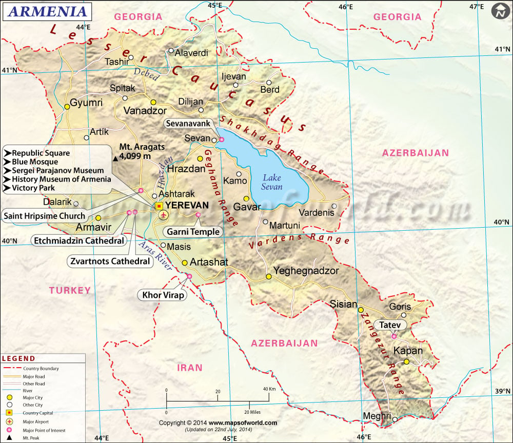
Map Credit: © Maps of the World (mapsofworld.com)
Click on map to enlarge it in a lightbox window.
ARMENIA (Հայաստան) is a landlocked country located in southwestern Asia, in an strategic area to the east of the Black Sea and west of the Caspian Sea. Armenia is east of Turkey, west of Azerbaijan, south of Georgia, and north of Iran and Naxçivan, which is a landlocked exclave of Azerbaijan. Naxçivan is not the only peculiar piece of land in the region; the other enclaves and exclaves are smaller than Naxçivan. Armenia has a small circular exclave located in western Azerbaijan with the town of Artsvashen inside it. Meanwhile, Azerbaijan has several small exclaves located within Armenia. South-central Armenia is the location for one of Azerbaijan's exclaves, with the town of Tigranashen inside. Two exclaves are located in northeast Armenia. These four territories, excluding Naxçivan, are so small that the longest length of them is only about 9.16 kilometers or 5.69 kilometers! The longest length of those territories belongs to the territory Artsvashen is in.
● ● ● ● ● People and Places ● ● ● ● ● According to Encyclopædia Britannica, Armenia’s population in the year 2020 was about 2,954,000 and was ranked 139th among populations of the whole world’s countries, dependencies, and territories. Armenia's population is fairly homogeneous given that most residents are of Armenian ethnicity and ancestry. With over 1 million residents, Yerevan is the capital and city with the highest population in Armenia. Other cities throughout Armenia include Ararat, Armavir, Gyumri, Kapan, Sisian, Step'anavan, and Vanadzor. Southwest of Yerevan, Karmir Blur (Կարմիր Բլուր) is an ancient settlement dating back to over 3,000 years ago. The currency is the Armenian Dram, and the ISO 4217 currency code is AMD. Armenian is the official language, with over 3 million speakers in the country. The Armenian language is also widely present in nearby Georgia and Russia. Minority languages spoken in Armenia include Assyrian, Georgian, Greek, Kurdish, and Russian.
● ● ● ● ● Land Features ● ● ● ● ● The Lesser Caucasus (Փոքր Կովկաս) mountain range stretches across northern and eastern Armenia. It is south of the mightier Greater Caucasus mountain range, which is located in northern Azerbaijan and northern Georgia. The highest point in Armenia and the Lesser Caucasus' is Mount Aragats (լեռ Արագած), a composite volcano standing over 4,000 meters and 13,400 feet. In eastern Armenia, Ozero Sevan (Սեւանա լիճ, or Sevana Lich) is by far the largest lake in the country. In comparison to Azerbaijan, a higher proportion of Armenian land is protected by national parks and reserves. Most of this area is in northern and southern Armenia. This post was updated on April 10th, 2015.

Blog Content
● The author of this GeoFact of the Day Blog creates and curates original, authentic content and posts information based on established facts. Blog posts are not generated by artificial intelligence (AI) but published by the author.
● Content and image graphics from other sources are properly credited. Many geography facts are well-established and therefore do not belong to any one source, but occasionally a fact requires attribution/credit if it is unique and hard-to-find — for example, facts found from specific cultural, anthropological, geological, and scientific (etc.) research.
● I do not copy and paste from other websites. Therefore, all posts are original but may sometimes include information, links, and/or images from credited external sources. To use a GeoFact of the Day Blog image for your website or project, write a comment below a post — then I may approve your request.
● Feel free to offer comments, suggestions, and compliments on any post or page! You can be anonymous. Spam comments with non-relevant links will be deleted.
● Thanks for your loyal readership on the educational and reliable GeoFact of the Day Blog, in existence since 2008!


