— Featured Post —
Welcome to GeoFact of the Day, where you can find fantastic facts about places, countries, cultures, languages, and other wonders of our world. I hope you enjoy!
New Map(s): Rwanda (January 2026)
New Update(s): Cambodia ● Let me know (comment on a post below) what country post(s) you want updated!
Facebook page: facebook.com/geographyfact
Search for Posts, Maps, and Topics
Tuesday, December 29, 2009
Armenia
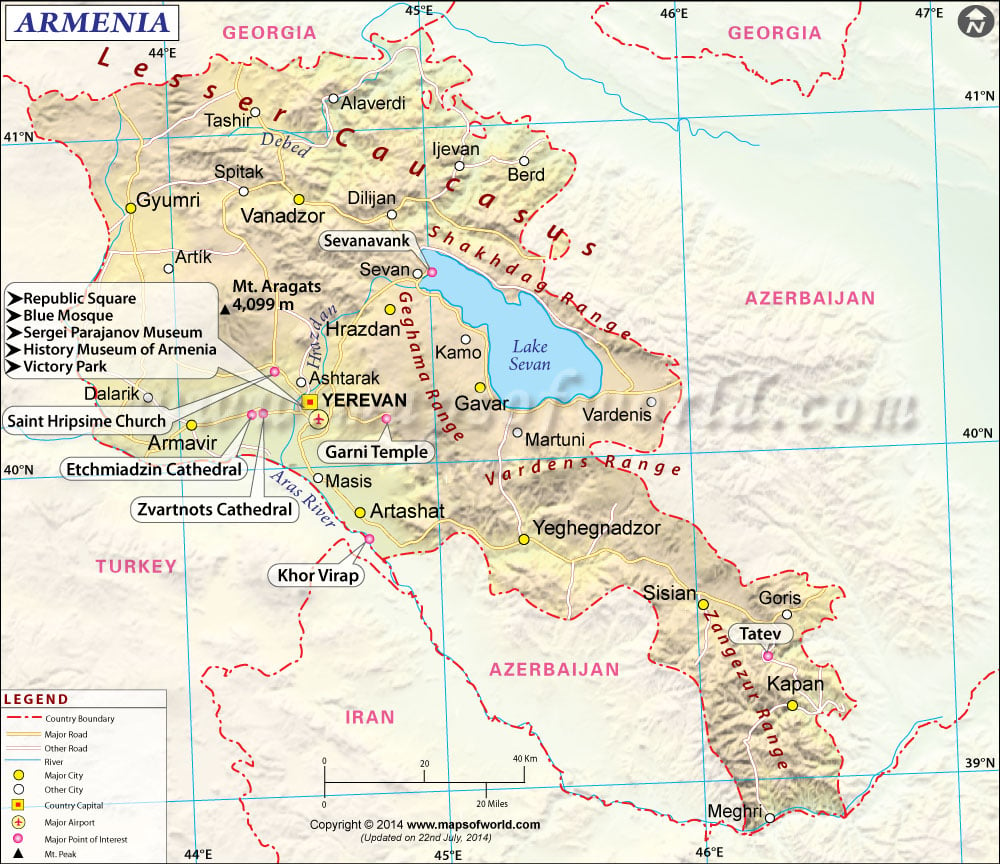
ARMENIA (Հայաստան) is a landlocked country located in southwestern Asia, in an strategic area to the east of the Black Sea and west of the Caspian Sea. Armenia is east of Turkey, west of Azerbaijan, south of Georgia, and north of Iran and Naxçivan, which is a landlocked exclave of Azerbaijan. Naxçivan is not the only peculiar piece of land in the region; the other enclaves and exclaves are smaller than Naxçivan. Armenia has a small circular exclave located in western Azerbaijan with the town of Artsvashen inside it. Meanwhile, Azerbaijan has several small exclaves located within Armenia. South-central Armenia is the location for one of Azerbaijan's exclaves, with the town of Tigranashen inside. Two exclaves are located in northeast Armenia. These four territories, excluding Naxçivan, are so small that the longest length of them is only about 9.16 kilometers or 5.69 kilometers! The longest length of those territories belongs to the territory Artsvashen is in.
● ● ● ● ● People and Places ● ● ● ● ● According to Encyclopædia Britannica, Armenia’s population in the year 2020 was about 2,954,000 and was ranked 139th among populations of the whole world’s countries, dependencies, and territories. Armenia's population is fairly homogeneous given that most residents are of Armenian ethnicity and ancestry. With over 1 million residents, Yerevan is the capital and city with the highest population in Armenia. Other cities throughout Armenia include Ararat, Armavir, Gyumri, Kapan, Sisian, Step'anavan, and Vanadzor. Southwest of Yerevan, Karmir Blur (Կարմիր Բլուր) is an ancient settlement dating back to over 3,000 years ago. The currency is the Armenian Dram, and the ISO 4217 currency code is AMD. Armenian is the official language, with over 3 million speakers in the country. The Armenian language is also widely present in nearby Georgia and Russia. Minority languages spoken in Armenia include Assyrian, Georgian, Greek, Kurdish, and Russian.
● ● ● ● ● Land Features ● ● ● ● ● The Lesser Caucasus (Փոքր Կովկաս) mountain range stretches across northern and eastern Armenia. It is south of the mightier Greater Caucasus mountain range, which is located in northern Azerbaijan and northern Georgia. The highest point in Armenia and the Lesser Caucasus' is Mount Aragats (լեռ Արագած), a composite volcano standing over 4,000 meters and 13,400 feet. In eastern Armenia, Ozero Sevan (Սեւանա լիճ, or Sevana Lich) is by far the largest lake in the country. In comparison to Azerbaijan, a higher proportion of Armenian land is protected by national parks and reserves. Most of this area is in northern and southern Armenia. This post was updated on April 10th, 2015.
Subscribe to:
Post Comments (Atom)
Blog Content
● The author of this GeoFact of the Day Blog creates and curates original, authentic content and posts information based on established facts. Blog posts are not generated by artificial intelligence (AI) but published by the author.
● Content and image graphics from other sources are properly credited. Many geography facts are well-established and therefore do not belong to any one source, but occasionally a fact requires attribution/credit if it is unique and hard-to-find — for example, facts found from specific cultural, anthropological, geological, and scientific (etc.) research.
● I do not copy and paste from other websites. Therefore, all posts are original but may sometimes include information, links, and/or images from credited external sources. To use a GeoFact of the Day Blog image for your website or project, write a comment below a post — then I may approve your request.
● Feel free to offer comments, suggestions, and compliments on any post or page! You can be anonymous. Spam comments with non-relevant links will be deleted.
● Thanks for your loyal readership on the educational and reliable GeoFact of the Day Blog, in existence since 2008!


No comments:
Post a Comment