

Update: the National Weather Service canceled this particular alert.
Update: the National Weather Service canceled this particular alert.
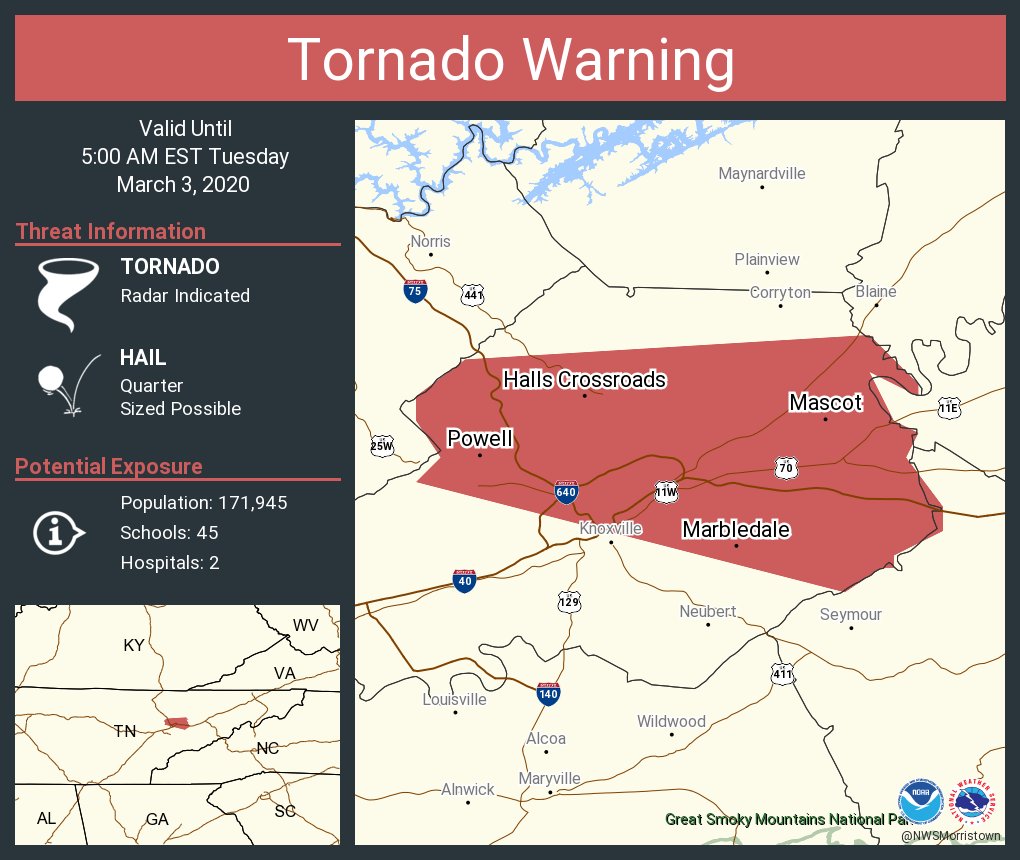
Tornado Warning
TNC093-031000-
/O.NEW.KMRX.TO.W.0006.200303T0935Z-200303T1000Z/
BULLETIN - EAS ACTIVATION REQUESTED
Tornado Warning
National Weather Service Morristown TN
435 AM EST Tue Mar 3 2020
The National Weather Service in Morristown has issued a
* Tornado Warning for...
Northeastern Knox County in east Tennessee...
* Until 500 AM EST.
* At 435 AM EST, a severe thunderstorm capable of producing a tornado
was located near Knoxville, moving east at 60 mph.
HAZARD...Tornado and quarter size hail.
SOURCE...Radar indicated rotation.
IMPACT...Flying debris will be dangerous to those caught without
shelter. Mobile homes will be damaged or destroyed.
Damage to roofs, windows, and vehicles will occur. Tree
damage is likely.
* This tornadic thunderstorm will remain over mainly rural areas of
northeastern Knox County, including the following locations...
Maloneyville, House Mountain State Park, Mascot, Powell, Halls and
Kimberlin Heights.
This includes the following highways...
Interstate 40 in Tennessee between mile markers 388 and 405.
Interstate 75 in Tennessee between mile markers 108 and 117.
PRECAUTIONARY/PREPAREDNESS ACTIONS...
TAKE COVER NOW! Move to a basement or an interior room on the lowest
floor of a sturdy building. Avoid windows. If you are outdoors, in a
mobile home, or in a vehicle, move to the closest substantial shelter
and protect yourself from flying debris.
Tornadoes are extremely difficult to see and confirm at night. Do not
wait to see or hear the tornado. TAKE COVER NOW!
&&
LAT...LON 3601 8408 3603 8406 3606 8408 3608 8408
3611 8404 3613 8371 3609 8367 3608 8367
3610 8371 3606 8369 3605 8367 3603 8368
3599 8365 3597 8365 3595 8369 3594 8369
3594 8370 3592 8373
TIME...MOT...LOC 0935Z 274DEG 53KT 3606 8399
TORNADO...RADAR INDICATED
HAIL...1.00IN
$$
Moulton
No comments:
Post a Comment