— Featured Post —
Welcome to GeoFact of the Day, where you can find fantastic facts about places, countries, cultures, languages, and other wonders of our world. I hope you enjoy!
New Map(s): Rwanda (January 2026)
New Update(s): Cambodia ● Let me know (comment on a post below) what country post(s) you want updated!
Facebook page: facebook.com/geographyfact
Search for Posts, Maps, and Topics
Thursday, May 21, 2015
Gambaga Scarp, West Africa
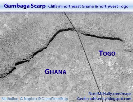
Gambaga Scarp is a physical landform feature located at the border of two regions in GHANA, a multilingual and English-speaking country in West Africa. A forested region of multiple cliffs along the Volta River basin, Gambaga Scarp horizontally stretches about 75 miles and 120 kilometers along the southern border of Upper East province and northeast border of Northern province. It also extends eastward to Tandjouaré prefecture (Savanes region) in northwestern TOGO.
The satellite image above — from randmcnally.com/maps and attributed to MapBox and OpenStreetMap — shows just a section of Gambaga Scarp near the border between Ghana and Togo. Crops such as yams and grain are grown and livestock are raised in the area with the help of a relatively cool microclimate. The region of cliffs is generally located over 1,000 feet and 300 meters in elevation. Various cities and small towns dot the area surrounding Gambaga Scarp. They include Bolgatanga, Gambaga, Nakpanduri, Nalerigu, Namasu, and Zarantinga in Ghana and Doré and Nano in Togo.
Subscribe to:
Post Comments (Atom)
Blog Content
● The author of this GeoFact of the Day Blog creates and curates original, authentic content and posts information based on established facts. Blog posts are not generated by artificial intelligence (AI) but published by the author.
● Content and image graphics from other sources are properly credited. Many geography facts are well-established and therefore do not belong to any one source, but occasionally a fact requires attribution/credit if it is unique and hard-to-find — for example, facts found from specific cultural, anthropological, geological, and scientific (etc.) research.
● I do not copy and paste from other websites. Therefore, all posts are original but may sometimes include information, links, and/or images from credited external sources. To use a GeoFact of the Day Blog image for your website or project, write a comment below a post — then I may approve your request.
● Feel free to offer comments, suggestions, and compliments on any post or page! You can be anonymous. Spam comments with non-relevant links will be deleted.
● Thanks for your loyal readership on the educational and reliable GeoFact of the Day Blog, in existence since 2008!


No comments:
Post a Comment