Informative geography facts about our wonderful planet, detailed and easy-to-read maps, and various topics about each country! I am pleased to update my blog as a passion project and do not generate content with AI.
Welcome to GeoFact of the Day, where you can find fantastic facts about places, countries, cultures, languages, and other wonders of our world. I hope you enjoy!
Officially known as the Kyrgyz Republic, KYRGYZSTAN (Кыргызстан) is a mountainous, central Asian country and was a former socialist republic of the Soviet Union until its 1991 independence. The country is located west of China, south of Kazakhstan, northeast of Tajikistan, and east of Uzbekistan. Kyrgyzstan's currency is the Kyrgyzstani Som, and its ISO 4217 currency code is KGS. Kyrgyzstan achieved independence from the Soviet Union on August 31st, 1991.
●●●●●People and Places●●●●● Home to about 1 million residents in 2017, the capital and largest city of Kyrgyzstan is Bishkek. Based on GeoFact of the Day's 2017 population estimates, the five cities with at least 50,000 inhabitants are Dzhalal-Abad (Jalal-Abad), Kara-Balta, Karakol, Osh (population: 250,000), and Tokmak (Tokmok). For basic geographic info about these cities, view my Kyrgyzstan's largest cities post — this link opens in a new tab or window. Other communities in Kyrgyzstan include Balykchy (Ysyk-Köl), Daroot-Korgon, Kyzyl-Kyya, Naryn, Ozgon, Sülüktü, Talas, and Terek-Say. Major languages used for communicating throughout the country include Dungan, Kyrgyz (national), Northern Uzbek, Russian (official), and Tajik or Tajiki. According to Ethnologue (↗), languages used by immigrants include but are not limited to Chechen, Crimean Tatar, Dargwa, Erzya, Karakalpak, Kazakh, Korean, Lezgi, North Azerbaijani, Northern Kurdish, Tatar, Turkish, Turkmen, Ukrainian, and Uyghur. About 65% of Kyrgyz citizens are Muslims, followed by Russian Orthodox Christians (20%), Buddhists (0.5%), adherents to ethnic religions (0.5%), and Zoroastrians (0.05%).
Several UNESCO World Heritage Sites (↗) pay homage to Kyrgyzstan's Silk Road-era history and the land's varied landscape. They are the Western Tien-Shen mountain range system (this large site is shared with Kazakhstan and Uzbekistan), Silk Roads and Chang'an-Tianshan Corridor (shared with China and Kazakhstan), and Sulaiman-Too Sacred Mountain. Other interesting places to see and visit throughout the country — with the city, village, or region location in parentheses — include Ak-Sai Glacier (Bishkek), Ala-Too Square (Bishkek), Altyn Arashan (Karakol) glacial valley with hot springs, Arslanbob Waterfalls (Arslanbob), Arslanbob Walnut Forest (Arslanbob), Burana Tower (Tokmok), Dungan Mosque (Karakol), Holy Trinity Russian Orthodox Cathedral (Karakol), Irkeshtam Pass (Osh), Konorchek Canyons (Bishkek), Museum of Fine Arts (Bishkek), Museum of Petroglyphs (Cholpon Ata), Nikolai Przhevalsky Museum (Karakol), Panfilov Park (Bishkek), Saimaluu-Tash Reserve Museum (Karakol), State History Museum (Bishkek), Uzgen Archaeological-Architectural Museum Complex (Uzgen), and various gorges/valleys. Read the Land Features section below for a succinct list of major mountain ranges, lakes, and rivers to explore.
Land-Feature Translations to English darıya or darya (Kyrgyz) = river khrebet (Russian) = mountain range ozero (Russian) = lake vodokhranilishche (Russian) = reservoir
●●●●●Land Features●●●●● Kyrgyzstan is quite mountainous; almost 70% of the country features mountain ranges belonging to the Pamir and dominant Tien Shan mountain-range groupings. The country's highest mountain — Jengish Chokusu, once commonly known as Pik Pobedy or Victory Peak — stands 7,439 meters and 24,406 feet in elevation. It is part of the Tien Shan range near the eastern tip of Kyrgyzstan. Mountain ranges include Alayskiy Khrebet (Alay or Alai) in southwestern Kyrgyzstan, Chatkal’skiy Khrebet (Chatkal) in the northwest, Ferganskiy Khrebet (Fergana) in the south, Khrebet Talasskiy Alatau (Talas Ala-Too) in the northwest, Khrebet Terskey Alatau (Terskey Ala-Too) in the northeast, Kirgizskiy Khrebet (Kirghiz) in the north, Kokshaal-Too in the southeast, and Zaalayskiy Khrebet (Trans-Alay) in the south.
Major rivers include Chu in the north, Kara Darya in the south, Naryn in the center, Talas in the northwest, and Vakhsh (Kyzyl-Suu) in the south. Known as Kyrgyzstan's longest river, Naryn flows for about 535 miles and 860 kilometers from the eastern highlands to the west toward Uzbekistan. Western Kyrgyzstan is home to one of the world's most-fertile regions: the Fergana Valley. Predominantly in Uzbekistan, the valley forms an arch along Kyrgyzstan's west border. Communities in this valley — see the detailed map below — include Dzhalal-Abad, Osh, and Uzgen. Kyrgyzstan's largest lakes and reservoirs include Ozero Chatyr-Kul' in the south, Ozero Issyk-Kul' in the northeast, Ozero Song-Köl in the north, and Toktogul'skoye Vodokhranilishche (Toktogul Reservoir). Containing about 1,738 cubic kilometers and 417 cubic miles of water, Issyk-Kul' is one of the world's largest lakes by volume.
KUWAIT is a relatively small, Middle-Eastern country located to the southeast of Iraq and northeast of Saudi Arabia. The population is over 3 million and growing steadily. The Persian Gulf borders eastern Kuwait. On the Persian Gulf coast, the capital of Kuwait is Kuwait City, spelled Al Kuwayt or al-Kuwayt in Arabic. The currency is the Kuwaiti Dinar, and its ISO 4217 currency code is KWD.
SOUTH KOREA is a democratic country on the southern part of the Korean Peninsula. The only bordering country is North Korea. Unlike North Korea, South Korea has a vital and prosperous economy thanks in part by the aftermath of the Korean War and American influence. Between North and South Korea is the infamous heavily-guarded Demilitarized Zone (DMZ). The capital of South Korea is Seoul, also spelled Sŏul. The currency is the South Korean Won (₩), and its ISO 4217 currency code is KRW.
NORTH KOREA is a Communist country on the northern part of the Korean Peninsula. China and a tiny border with Russia are north, while South Korea is aptly south. The Korea Bay (part of the largest Yellow Sea) is west of North Korea, and the Sea of Japan is on the east coast. Beyond the Sea of Japan to the east is Japan. Separating North and South Korea is the infamous Demilitarized Zone (DMZ), a heavily guarded border indicative of the two countries' polarized relationship. According to Encyclopædia Britannica, North Korea’s population in the year 2020 is about 25,779,000 and is ranked 54th among populations of the whole world’s countries, dependencies, and territories. The capital is Pyongyang, also spelled P'yŏngyang. North Korea's currency is the North Korean Won, and its ISO 4217 currency code is KPW.
Also known as QAZAQSTAN, the Republic of KAZAKHSTAN is a large, former Soviet Republic located in Central Asia, bordering 5 countries: China, Kyrgyzstan, Russia, Turkmenistan, and Uzbekistan. The western part of the country is in Europe. There are a couple of well-known bodies of water that border this country: the Caspian Sea, which is actually a large lake; and the Aral Sea, a lake that is shrinking at a rapid rate. The capital of Kazakhstan is Astana. Almaty, Kazakhstan's most populated city as of 2024, served as the country's first capital after independence in the 1990s. Kazakhstan's currency is the Kazakhstani Tenge; the ISO 4217 currency code is KZT.
Officially known as the Hashemite Kingdom of Jordan, JORDAN (الأردن) is a Middle Eastern country with a population near 6.7 million. Jordan's total area is 89,340 square kilometers and 34,495 square miles. Israel is located to the west of Jordan, and beyond Israel is the Mediterranean Sea. Saudi Arabia is southeast of Jordan and Syria is north, while the eastern panhandle of Jordan is west of Iraq. The capital of Jordan, located in the northern part of the country, is Amman ('Ammān). The currency is the Jordanian Dinar, and its ISO 4217 currency code is JOD.
JAPAN (Nippon) is located in Eastern Asia and is comprised of four major islands and many smaller islands. Honshu, Hokkaido, Kyushu, and Shikoku are Japan's main islands. Surrounding water bodies include the Sea of Japan (west), Philippine Sea (south), and the North Pacific Ocean (east/southeast). The capital of Japan is Tokyo (Tōkyō), and the metropolitan area has a population over 35,600,000! The currency is the Japanese Yen (¥), and its ISO 4217 currency code is JPY.
ISRAEL, the birthplace of global religions like Christianity and Judaism while being a hotspot for civil conflicts, is located in the Middle East. It border four countries; Egypt and its Sinai Peninsula is to the southwest, Jordan is to the east, Lebanon is north of Israel, and Syria borders Israel to the northeast. Israel's complete western coast borders the Mediterranean Sea. Seen as a light blue color to the east of northern Israel on my map, the GOLAN HEIGHTS is a region currently belonging to Israel but claimed by Syria. Palestinians have a small level of self-governance and autonomy in the GAZA STRIP and WEST BANK, but these areas are stricken by frequent conflicts between Israelis and Palestinians. Israel's currency is the Israeli New Shekel, and its ISO 4217 currency code is ILS. Previous currencies included the Israeli Lira (1952-1980) and (Old) Shekel (1980-1985). On May 14th, 1948, Jewish Agency chairman David Ben-Gurion declared independence of Israel once the British mandate of Palestine was terminated.
●●●●●People and Places●●●●●
The capital, located partially within and to the west of the West Bank, is Jerusalem. Jerusalem is mainly split into separate residential quarters for worshippers of different religions. Marked with a red open circle in my map, Subeita is an ancient city in southwest Israel. Other ancient cities and villages scattered throughout Israel include Korazim, Lakhish, and Samaria (Shomron).
SECTION WILL BE EXPANDED SHORTLY!
●●●●●Land Features●●●●●
The Dead Sea is located on the Israel-Jordan border. The Gulf of Aqaba — which connects with the larger Red Sea located to the south — is south of Israel and the city of Elat. The Negev Desert stretches across southern Israel, setting a contrast to a Mediterranean climate in which fruits, vegetables, and grains can grow elsewhere in the country.
The Republic of IRAQ is a Middle Eastern country, touching the Persian Gulf along a 66-kilometer (41-mile) coastline. There are six bordering countries: Iran, Jordan, Kuwait, Saudi Arabia, Syria, and Turkey. Located along the diagonal Tigris river, the capital of Iraq is Baghdad (Baghdād). West of the Tigris river is another historically important river: Euphrates. Mesopotamia is the world's earliest known area of human civilization where widespread agriculture took root. Iraq's currency is the Iraqi Dinar, and its ISO 4217 currency code is IQD.
With a population greater than 77 million, the Islamic Republic of IRAN (ایران) is located in the Middle East with the Gulf of Oman, Persian Gulf, and Caspian Sea bordering the theocratic country. The Strait of Hormuz connects the Gulf of Oman and Persian Gulf and bypasses the United Arab Emirates and Oman's Musandam Governorate to the south. Both gulfs are located south of Iran, while the Caspian Sea is north. There are seven countries bordering Iran via land: Afghanistan and Pakistan to the east, Armenia, Azerbaijan, and Turkey to the northwest, Iraq to the west, and Turkmenistan to the northeast. The capital of Iran is Tehran (Tehrān, تهران), which has a population of approximately 8.16 million (2016 estimate). Located near Turkmenistan in northeastern Iran, Mashhad (مشهد) is the second-largest city by population. Over 2.77 million residents call the 9th-century ancient city home. Other cities throughout Iran include Chābahār (southeastern Iran, along Gulf of Oman), Esfahan (Isfahan, أصفهان), Kermānshāh, Shīrāz, Tabrīz, and Zāhedān. The currency is the Iranian Rial, and its ISO 4217 currency code is IRR.
INDONESIA is a predominantly Muslim country possessing around 17,000 islands and is located in Southeastern Asia. There are three bordering countries: East Timor, Malaysia, and Papua New Guinea. The capital of Indonesia is Jakarta; it is located on the western part of Java island. The currency is the Indonesian Rupiah; the ISO 4217 code is IDR.
Islands
People live on about 6,000 out of the 17,000 islands of Indonesia. Indonesia occupies the western half of New Guinea, the second largest island in the world. Borneo is the third largest island in the world, while Sumatra is the sixth largest. Other major islands include Celebes, Java, and Timor.
People
The population of Indonesia, as of October 2012, is 240,000,000. The four largest ethnic groups are Javanese (45%), Sundanese (14%), Madurese (8%), and Malay (8%). Almost 90% of Indonesians are Muslims; others are Protestants, Roman Catholics, Hindu, Buddhist, etc. The official language is Bahasa Indonesia, which is modified from Malay.
Discover more about Borneo, New Guinea, and Sumatra by visiting The Largest Islands feature on my Islands page.
Especially known as one of the world's most-populated countries, INDIA is located in South Asia on the Indian subcontinent. India borders a total of six countries. Bangladesh is east of a vast majority of India and south of the Indian panhandle area. East of India is Myanmar (Burma), west of India is Pakistan, and Bhutan, China, and Nepal are situated northeast of India. The aptly-named Indian Ocean is south of India. Part of the Indian Ocean, the Arabian Sea is west of India, while the Bay of Bengal is east. A teardrop-shaped island country, Sri Lanka, is south of India. The capital of India is New Delhi, which has about 318,000 residents. Despite being the capital, New Delhi is definitely not one of India's most-populated cities; the city is ranked about 128th in terms of population. Cities with well over 1 million residents include Ahmedabad (over 3.7 million), Bengaluru (over 4.9 million), Chennai (over 4.6 million), Delhi (over 10.9 million), Hyderabad (3.6 million), Kolkata (Calcutta; over 4.6 million), Mumbai (over 12.7 million), and Pune (almost 3 million). Population statistics were updated on January 22nd, 2016. Hindi (हिन्दी) is India's official language, while English is also spoken especially among government officials — a leftover legacy from British colonization. Other major languages spoken in India include Bengali, Telugu, Marathi, Tamil, Urdu, Gujarati, Malayalam, Kannada, and Oriya. Regarding the country's currency, Indians use the Indian Rupee. The Rupee's ISO 4217 currency code is INR.
Translated from the Cantonese language to English as "fragrant harbor" due to aromatic Heung trees ("incense trees"), HONG KONG (香港) juts out into the South China Sea and is one of two special administrative regions — along with Macau — belonging to China. Hong Kong borders China along the territory's northern border, and the city of Shenzhen is across the border. the United Kingdom transferred sovereignty of Hong Kong to China in 1997. The former capital before 1997 was Victoria. Communities and areas in Hong Kong include Happy Valley, Miu Tsai, Shek Wan, the Tai Po District, and Wo Hop Shek. Hong Kong's currency is the Hong Kong Dollar, and its currency code abbreviation is HKD. Hong Kong's currency is widely used and traded for global commerce, and its economy is dominated by finance and trading activities.
GEORGIA, a Eurasian country in Asia, is located above Azerbaijan and Armenia. Georgia's northern portion is sometimes considered to be in Europe. This country borders the eastern side of the Black Sea and is north of Turkey and south of Russia. The capital of Georgia is Tbilisi (T'bilisi), which is located in eastern Georgia. Other major cities include Sokhumi, Bat'umi, K'ut'aisi, and Rust'avi. Like T'bilisi, these cities are sometimes spelled without apostrophes. Almost three-fourths (75%) of the population is of the Georgian ethnicity. Other people living in Georgia include Azeris (from Azerbaijan), Armenians, and Russians. The Georgian Orthodox tradition has the most worshippers in Georgia. The currency is the Georgian Lari, and its ISO 4217 currency code is GEL.
EAST TIMOR, also called TIMOR-LESTE, is a small and economically impoverished island country located in Southeastern Asia. Hence the name, the country is located on the eastern part of the island of Timor, which is east of the string of islands that include Java and Bali; the western portion of Timor belongs to Indonesia. The Timor Sea is south of East Timor, while the Selat Wetar (Wetar Strait) is north and is south of Wetar island. The capital, located on the northern shore, is Dili. The currency that citizens use is the United States Dollar (USD). East Timor Centavos coins circulate with the US Dollar, but there are no banknotes.
Right-click to open image in a new tab to view the map in its full size.
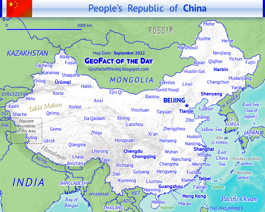
Officially named the People’s Republic of China (PR China, 中华人民共和国) and also known as ZHŌNGGUÓ, CHINA is a Communist country in Eastern Asia and has the largest population of any country in the world: approximately 1.4 billion (2017). The Chinese nation boasts a comprehensive, longstanding history involving the tenets of education, intense leadership, and innovation/inventions. Partially confirmed by historic records, Xia (Hsia) is the first dynasty ruling over ancient China — in existence from the years 2,100 to 1,600 BCE/BC. View the Timeline of Chinese History and Dynasty (↗) by Columbia University for a concise overview of China’s past. A total of 14 countries border China: Afghanistan (small border), Bhutan, India, Kazakhstan, Kyrgyzstan, Laos, Mongolia, Myanmar (Burma), Nepal, North Korea, Pakistan, Russia, Tajikistan, and Vietnam. From north to south, the Yellow Sea, East China Sea, and South China Sea (a.k.a. South Sea or Nan Hai) are water bodies situated east and south of China. China’s currency is the Chinese Renminbi, and the ISO 4217 currency code is CNY. In the Renminbi currency, one yuan equals 10 jiao and 100 fen. PRC China’s founding officially began on September 21st, 1949, and citizens annually celebrate National Day on October 1st.
Chinese Calendar year: 4721
4721 is the Huángdì year for most of 2024 to early 2025
●●●●●People and Places●●●●● Boasting a metropolitan population greater than 21 million, Beijing is China’s capital but surprisingly not the country’s largest city. That designation belongs to Shanghai, which has about 3 million more residents than Beijing in its metropolitan area. Other major cities throughout China include Changsha, Chengdu, Chongqing, Foshan, Fuzhou, Guangzhou, Guilin, Hangzhou, Harbin, Jinan, Kunming, Nanjing, Nanning, Ningbo, Qingdao, Shenyang, Shenzhen, Shijiazhuang, Suzhou, Ürümqi, Wuhan, Xi’an, Xiamen, Yantai, Zhengzhou, and Zhongshan. Attractions, landmarks, and sites of interest in China — with city location(s) listed in parentheses — include but are certainly not limited to the Bund International Architecture Exhibition (Shanghai), City of Dreams (Macau), Great Wall of China (Datong, Huairou, Lanzhou, Yinchuan, etc.), Historic Center of Macau, Jingshan Park (Beijing), Jiuzhaigou Nature Reserve (Jiuzhaigou), Jokhang Temple (Lhasa), Longmen Grottoes (Luoyang), Mogao Caves (Dunhuang), Potala Palace (Lhasa in Tibet), Shanghai Circus World (Shanghai), skyscrapers of Beijing and Hong Kong (among other modern cities), Summer Palace (Beijing), Temple of Heaven (Beijing), Ten Thousand Buddhas Monastery (Hong Kong), terracotta warriors of the First Qin Emperor Mausoleum (Xi’an), Tiananmen Square (Beijing), Wuzhen Water Town (Tongxiang), and Xinjiang Regional Museum (Ürümqi).
Coastal provinces and other administrative regions from north to south are Liaoning, Hebei, Tianjin (municipality), Shandong, Jiangsu, Shanghai (municipality), Zhejiang, Fujian, Guangdong, Guangxi Zhuang Autonomous Region, and Hainan. China possesses two special administrative provinces (SARs): HONG KONG (↗) and MACAU (↗), both located in the South China Sea’s Pearl River Delta (Zhu Jiang Sanjiaozhou). Five autonomous regions with local governments sit within PR China. From smallest to largest, they are Ningxia, Guangxi, Nei Mongol (Inner Mongolia), Tibet (Xizang), and Xinjiang. Also known as the Republic of China (ROC), TAIWAN (↗) is a self-governing entity but has not achieved full independence from the mainland. About twenty countries recognize Taiwan as an independent state and maintain diplomatic relations with its government. Some countries are opposed to Taiwan’s sovereignty in fear of consequences brought on by PR China. For example, the One-China Policy states that the PR China’s diplomatic relations with countries recognizing Taiwan’s sovereignty could be halted.
The official language of national identity for China, Mandarin (Standard) Chinese is the world’s most used language for communication. As of 2017, over 1.1 billion people — that number could very well be higher — speak and write with Mandarin Chinese. Cantonese (Yue) is either considered a Mandarin dialect or an official language in Hong Kong and Macau. Another official language of Hong Kong is English; Portuguese is official in Macau. Other majorly communicated languages — and namesake ethnic groups pertaining to some languages — include Akha, Bai, Bouyei, Bunu (Bu-Nao), Gan Chinese, Hakka Chinese, Huizhou Chinese, Jinyu Chinese, Min Bei Chinese, Min Dong Chinese, Min Nan Chinese, Min Zhong Chinese, Pu-Xian Chinese, Wu Chinese, Xiang Chinese, Dong (Northern and Southern), Dongxiang, Hani, Hmong, Iu Mien, Kaduo, Kazakh, Kim Mun, Korean, Kyrgyz, Lahu, Central Lalo, Lingao, Lisu, Lolopo, Lü, Miao, Mongolian, Nasu (Wumeng and Wusa), Naxi, Nisu (especially Northern and Southern), Nuosu, Parauk Wa, Russian, Sinicized Miao, Sui, Tai Nüa, Tibetan (Amdo, Central, and Khams), Uyghur (Uighur), Waxianghua, Wuding-Luquan Yi, and various forms of Zhuang. About half of the Chinese population adheres to the tenets of religions. The relatively high rates of atheism is a vestige of religious bans during Mao Zedong’s dictatorial rule. Prominent religions worshiped today in China include Chinese Universism (almost 30% of China’s population), Buddhism (8.5%), Christianity (8.5%), ethnic religions (4.4%), and Islam (1.5%) — followed by Bahá’í Faith, Confucianism, Daoism (Taoism), Hinduism, Judaism, Sikhism, Spiritism, and Zoroastrianism.
●●●●●Land and Water Features●●●●● The Tien Shan mountains, Taklimakan Desert, Kunlun mountains, Tibetan Plateau, and the Himalaya mountains dominate Western China, from north to south. The Gobi Desert stretches vertically across northern China and southern Mongolia. Northeast China features the Greater Khingan volcanic mountain range and the Manchurian Plain. Hainan is the People’s Republic of China (PRC)’s largest island. If the Republic of China was included in island-related statistics, then Taiwan would be the largest island of China. Taiwan encompasses an area of 35,980 km² and 13,892 mi² versus Hainan’s 33,210 km² and 12,822 mi².
Major lakes are mostly located in mountainous and glacial regions in southern China (especially in Tibet) but also interspersed among rivers in eastern China, near cities such as Nanjing, Suzhou, and Wuhan. The largest lake in China, Qinghai is situated south of the Gobi Desert in north-central China (Qinghai Province). Other large lakes include Aqqikkol, Ayakkum, Chao, Dagzê, Fuxian, Har, Hulun, Nam, Poyang, Shaobo, Siling, Tai, and Ulansu. China’s longest river, the Yangtze (Cháng Jiāng), originates from a glacier on the Tibetan Plateau and flows eastward past cities such as Lijiang, Chongqing, Yichiang, Yueyang, Wuhan, Huangshi, Wuhu, Ma’anshan, Nanjing, Zhenjiang, Nantong, and Shanghai. Other rivers include Amur (Heilong Jiang), Huang He (Yellow), Mekong, Pearl River system (Bei, Dong, and Xi rivers), Salween, and Yarlung Zangbo (connected to Brahmaputra).
The China post was updated with more information on May 25th, 2017.
CAMBODIA is an Indochinese country in Southeast Asia that borders the countries of Laos, Thailand, and Vietnam. This country was formerly known as Kampuchea. The capital of Cambodia is Phnom Penh! The currency is the Cambodian Riel, and its ISO 4217 currency code is KHR. A significant, well-known, and historical structure is Angkor Wat, a Khmer temple built in the early 1100s (12th century) and located north of Siem Reap (Siemreab) city as well as Tônlé Sap, Cambodia’s largest lake.
●●●●●People and Places●●●●● According to Encyclopædia Britannica, Cambodia’s population in the year 2020 was about 15,535,000 and was ranked 71st among populations of the whole world’s countries, dependencies, and territories. Phnom Penh is Cambodia’s economic capital and largest city with a population of over 1,500,000. Other Cambodian cities include Batdambang (Battambang), Kampong Cham, Kracheh, Phumi Samraong, Siemreab (Siem Reap), Sihanoukville, and Sisophon. Designated due to cultural and natural importance, UNESCO World Heritage Sites located throughout Cambodia include the iconic Angkor Wat — added to the World Heritage List in 1992 — as well as Angkor Thom (Bayon Temple), Ker archaeological site, Preah Vihear Temple, and Sambor Prei Kuk Temple Zone. Other notable places and sites of interest all across the country include the Royal Palace and its Silver Pagoda; tenth-century Banteay Srei Temple; twelfth-century Ta Prohm Temple and its Terrace of the Elephants; PH Euro Park, built to imitate quintessentially European sights such as the Eiffel Tower and Dutch windmills (but there’s also a mini Sydney Opera House as a non-European bonus); the bustling Central Market; the vibrantly lit nightlife hub of Pub Street; and the Tuol Sleng Memorial Museum.
As of 2025, approximately 27 languages are used for communication in Cambodia, including the following languages: Khmer (official), Central Mnong, Chinese (Mandarin, Min Nan, and Yue), English, French, Jarai, Kaco’, Kraol, Kravet, Kru’ng, Kuy, Lao, Lave, Somray, Stieng Bulo, Tampuan, Thai, Vietnamese, and Western Cham. A majority of Cambodians have Khmer heritage, while some residents have Chinese or Vietnamese ethnicity. Theravada Buddhist is the official and majority (~86%) religion of Cambodia. Ethnic religions, Chinese Universalism, Islam, Christianity, Hinduism, Bahá’í, etc. are minority beliefs and religions.
●●●●●Land and Water Features●●●●●Tônlé Sap is by far the largest lake in Cambodia and sits across the country’s central and northwest areas. The Mekong is the longest river and is revered and well-traveled. This mighty river starts in the northeast, goes straight south, veers southwest towards Phnom Penh, flows eastward and southward into southern Vietnam, then empties into the Mekong Delta — and subsequently the East Sea (South China Sea). Cambodia’s curvy southwest coastline abuts the Gulf of Thailand. Other Cambodian rivers and tributaries include the Bassak, Chas, Chinit, Kong, Peam, Sab, San, Sen, Sreng, and Srêpôk. There are several waterfalls throughout the countryside, one of which is Kbal Chhay located northeast of Sihanoukville in southern Cambodia. On the other side of Cambodia are the Khone Falls where the Mekong enters Cambodia from Laos. Bokor and Phnom Kulen national parks have waterfalls. Several islands of Cambodia have waterfalls, most notably the three or so waterfalls on the island of Kaoh Rung (Koh Rong). Immediately north of Sihanoukville is a bay named Chhak Kampong Saom (Kompong Som Bay).
Sprinkled in the rivers and bays of Cambodia are dozens of islands with all sorts of shapes and sizes. In addition to Koh Rong mentioned above, some island examples include Chanloh, Dach (Silk), Damlaung, Daong, Dek Koul, Koh Ki, Koh Kapi, Kong, Oknha Tei, Preab, Pring, Puos, Rong Sanloem, Russey (Bamboo), Seh, Ta Kiev, Tang, Thas, and Thmei. Mount Sâmkôs (1743 meters) and Mount Aôral (1813 meters) both stand almost like goalposts for the “football” known as the Krâvanh Mountains. The Dâmrei Mountains are further south near the aforementioned Chhak Kampong Saom. Conversely, the Dangrek Mountains straddle the northern border with eastern Thailand. Including Bokor and Phnom Kulen national parks mentioned above, here are some preserves and wildlife sanctuaries throughout Cambodia: Kulen Prum Tep, Lumphat, Phnom Sâmkôs, Ream, Roneam Daun Sam, and Virachey.
Map Note: The island of Ãao Phu Quôc belongs to Vietnam. On my newest versions of maps, islands that are green or white (with transparency) belong to other countries.
This post was updated with more information in July 2025.
Officially known as the Nation of Brunei, the Abode of Peace in English and Negara Brunei Darussalam in Malay, BRUNEI is a relatively tiny country located on the island of Borneo. Brunei borders one country, Malaysia, on its western, southern, and eastern borders. The predominantly Muslim country also borders the South China Sea along its northern coast. Over 426,000 residents live in Brunei. Bruneians speak Malay (Brunei dialect) as the official language in addition to Belait, Bisaya, Chinese, English, Iban, Tutong, and others. The capital of Brunei is Bandar Seri Begawan, which has a population greater than 64,000. Other communities in Brunei include Badas, Bangar, Kuala Belait, Labi, Muara, Seria, and Tutong. The currency is the Brunei Dollar, and its ISO 4217 currency code is BND. Sultan, leader, and billionaire Hassanal Bolkiah is known to be one of the world's richest individuals and even has shiny gold-plated Mercedes-Benz and Rolls-Royce vehicles. Brunei's sparsely-populated southern tier is dominated by rainforests and natural preserves, such as Ulu Temburong National Park. To access a detailed post about Brunei, visit this post about Brunei's rivers.
This post was updated with a new map on August 17th, 2016.
BHUTAN is a relatively small, landlocked country located in the Himalayan Mountains of Southern Asia. The mountain kingdom's total surface area is 47,700 square kilometers and 18,417 square miles. Bhutan is south of China and northeast of India. The capital and most-populated city of Bhutan is Thimphu, with a GeoFact of the Day Blog-estimated population of 92,000 (2016). Other communities include Chhukha, Damphu, Dzongsa, Gasa, Geylegphug, Ha, Jakar, Lingshi, Louri, Lhuntsi Dzong, Mongar, Paro, Pemagatsel, Phuntsholing, Punakha, Sakteng, Samchi, Samdrup Jongkhar, Sarbhang, Thunkar, Trashigang, Trongja, Wangdiphodrang (Wangdue Phodrang), and Zhemgang. The official language is Dzongkha, the main religion is Buddhism, the life expectancy is around 53 years, and the literacy rate is 42% (source: The Children's World Atlas. New York: Barnes & Noble Books, 2004.). Bhutan's currency is the Ngultrum, and its ISO 4217 currency code is BTN.
BANGLADESH is located in Southern Asia. The country is about 50% surrounded by India on the west, north, and east; the Bay of Bengal is south and the country Myanmar is to the southeast. The capital of Bangladesh is Dhaka. The currency is the Bangladeshi Taka, and the ISO 4217 currency code is BDT.
BAHRAIN, made up of 33 islands, is the smallest Middle Eastern country with an area of 293.4 square miles and 759.9 square kilometers. Regardless of its relatively small size, it is home to over 1.35 million residents. Bahrain is east of Saudi Arabia and northwest of Qatar. The country is located near the Persian Gulf's western side, while the Gulf of Bahrain vertically separates the western coasts of Bahrain and Qatar from Saudi Arabia's eastern coast. The capital of Bahrain is Manama, also spelled Al Manāmah. The currency is the Bahraini Dinar, and its ISO 4217 currency code is BHD.
● The author of this GeoFact of the Day Blog creates and curates original, authentic content and posts information based on established facts. Blog posts are not generated by artificial intelligence (AI) but published by the author.
● Content and image graphics from other sources are properly credited. Many geography facts are well-established and therefore do not belong to any one source, but occasionally a fact requires attribution/credit if it is unique and hard-to-find — for example, facts found from specific cultural, anthropological, geological, and scientific (etc.) research.
● I do not copy and paste from other websites. Therefore, all posts are original but may sometimes include information, links, and/or images from credited external sources. To use a GeoFact of the Day Blog image for your website or project, write a comment below a post — then I may approve your request.
● Feel free to offer comments, suggestions, and compliments on any post or page! You can be anonymous. Spam comments with non-relevant links will be deleted.
● Thanks for your loyal readership on the educational and reliable GeoFact of the Day Blog, in existence since 2008!
Thanks for Visiting from Anywhere in the World!
Over 470,000 views as of October 2023 — thank you!


 CAMBODIA is an Indochinese country in Southeast Asia that borders the countries of Laos, Thailand, and Vietnam. This country was formerly known as Kampuchea. The capital of Cambodia is Phnom Penh! The currency is the Cambodian Riel, and its ISO 4217 currency code is KHR. A significant, well-known, and historical structure is Angkor Wat, a Khmer temple built in the early 1100s (12th century) and located north of Siem Reap (Siemreab) city as well as Tônlé Sap, Cambodia’s largest lake.


